Category:Roman villa, L'Etrey
| Object location | | View all coordinates using: OpenStreetMap |
|---|
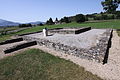
archaeological site in Riaz in the canton of Fribourg, Switzerland  | |||||
| Upload media | |||||
| Instance of |
| ||||
|---|---|---|---|---|---|
| Part of | |||||
| Location |
| ||||
| Street address |
| ||||
| Heritage designation | |||||
 | |||||
Media in category "Roman villa, L'Etrey"
The following 3 files are in this category, out of 3 total.
-
 Gallo Roman Temple Riaz Aug 2011.jpg 4,752 × 3,168; 7.52 MB
-
 L'Etrey, villa gallo-romaine 2.jpg 2,736 × 3,648; 4.25 MB
-
 L'Etrey, villa gallo-romaine.jpg 9,920 × 2,240; 5.87 MB
