Category:Ropers Bridge
| Object location | | View all coordinates using: OpenStreetMap |
|---|
bridge in Whiston, Knowsley, Merseyside, UK  | |||||
| Upload media | |||||
| Instance of | |||||
|---|---|---|---|---|---|
| Location | Whiston, Knowsley, Merseyside, North West England, England | ||||
| Heritage designation |
| ||||
 | |||||
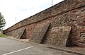
This is overline bridge DSE/65 on the Deal Street and Edge Hill Branch of the Merseyrail City Line; built 1829 by George Stephenson for the Liverpool and Manchester Railway, it is Grade II listed. It is 7.51 miles from Lime Street.
Media in category "Ropers Bridge"
The following 11 files are in this category, out of 11 total.
-
 Benchmark on Ropers Bridge, Whiston.jpg 3,456 × 4,608; 15.36 MB
-
 Roper's Bridge 1.jpg 5,134 × 3,099; 12.65 MB
-
 Roper's Bridge 2.jpg 5,115 × 3,306; 13.82 MB
-
 Roper's Bridge 3.jpg 5,151 × 3,360; 15.88 MB
-
 Roper's Bridge, Whiston.jpg 640 × 480; 450 KB
-
 Ropers Bridge 4.jpg 5,095 × 3,270; 14.3 MB
-
 Ropers Bridge 5.jpg 5,128 × 3,029; 11.14 MB
-
 Ropers Bridge 6.jpg 5,319 × 3,147; 14.13 MB
-
 Ropers Bridge 7.jpg 5,019 × 3,258; 12.41 MB
-
 View east from Ropers Bridge.jpg 4,608 × 3,456; 16.42 MB
-
 View west from Ropers Bridge.jpg 4,152 × 3,315; 13.17 MB


