Category:Ross Island (Andaman)
island in South Andaman Islands, India  | |||||
| Upload media | |||||
| Instance of | |||||
|---|---|---|---|---|---|
| Part of | |||||
| Named after |
| ||||
| Location | Port Blair tehsil, South Andaman district, Andaman and Nicobar Islands, India | ||||
| Located in or next to body of water | |||||
| Width |
| ||||
| Length |
| ||||
| Population |
| ||||
| Area |
| ||||
| Elevation above sea level |
| ||||
 | |||||
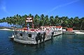
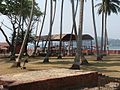
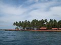
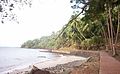
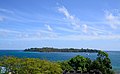
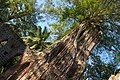
Ross Island was the Administrative Headquarters for the today's Union Territory Andaman and Nicobar Islands (India), before an earthquake rocked it in 1941. The headquarters were then shifted to Port Blair on Andaman Island.
wikipedia:en:Ross Island (Andaman) wikipedia:hi:रॉस द्वीप wikipedia:id:Pulau Ross (Andaman)
Subcategories
This category has the following 2 subcategories, out of 2 total.
N
R
Media in category "Ross Island (Andaman)"
The following 48 files are in this category, out of 48 total.
-
 Andaman ross is.jpg 1,000 × 662; 706 KB
-
 Bakery, Ross Island.JPG 2,048 × 1,463; 781 KB
-
 British era ruins on Ross Island of Port Blair.jpg 1,968 × 4,160; 3.65 MB
-
 Captain Ross View 01.jpg 3,264 × 2,448; 1.87 MB
-
 Captain Ross View 02.jpg 2,448 × 3,264; 1.99 MB
-
 Captain Ross View 03.jpg 2,448 × 3,264; 1.91 MB
-
 IMG rossisland bakery.jpg 640 × 480; 125 KB
-
 IMG rossisland openairtheatre.jpg 640 × 480; 109 KB
-
 Ross island - Andaman.jpg 1,570 × 445; 181 KB
-
 Ross Island 4130151.JPG 3,648 × 2,736; 3.83 MB
-
 Ross Island Andaman 4140009.JPG 3,648 × 2,736; 4.01 MB
-
 Ross Island Andaman 4140010.JPG 3,648 × 2,736; 3.5 MB
-
 Ross Island Andaman 4140034.JPG 3,648 × 2,736; 3.89 MB
-
 Ross Island Andaman 4140037.JPG 3,648 × 2,736; 3.36 MB
-
 Ross Island Andaman 4140043.JPG 3,648 × 2,736; 4.27 MB
-
 Ross Island Andaman 4140048.JPG 3,648 × 2,736; 4.1 MB
-
 Ross Island Andaman 4140057.JPG 3,648 × 2,736; 3.97 MB
-
 Ross Island Andaman 4140058.JPG 2,736 × 3,648; 4.04 MB
-
 Ross Island Andaman 4140059.JPG 3,648 × 2,736; 4.35 MB
-
 Ross Island Andaman 4140060.JPG 3,648 × 2,736; 3.73 MB
-
 Ross Island Andaman 4140061.JPG 3,648 × 2,736; 3.76 MB
-
 Ross Island Andaman 4140064.JPG 3,648 × 2,736; 4.34 MB
-
 Ross Island Andaman 4180345.JPG 3,648 × 2,736; 3.71 MB
-
 Ross Island Andaman Islands.jpg 6,767 × 1,922; 6.3 MB
-
 Ross Island Andaman.jpg 3,056 × 2,292; 1.06 MB
-
 Ross Island banner Ruins.jpg 3,712 × 534; 399 KB
-
 Ross island beach.JPG 3,955 × 2,441; 1.82 MB
-
 Ross Island Beach.jpg 4,096 × 2,304; 2.58 MB
-
 Ross island church.JPG 3,000 × 4,000; 2.14 MB
-
 Ross Island from Cellular Jail.jpg 5,986 × 3,689; 3.57 MB
-
 Ross Island India.jpg 3,056 × 2,292; 1.2 MB
-
 Ross island japanese bunkers.JPG 640 × 480; 81 KB
-
 Ross Island jetty in Port Blair, Andaman Island.jpg 2,736 × 1,824; 2.69 MB
-
 Ross Island jetty, Port Blair in Andaman Island.jpg 2,736 × 1,824; 2.5 MB
-
 Ross Island Jetty.jpg 4,096 × 2,304; 4.44 MB
-
 Ross Island, Andamans, Banyan tree.jpg 4,032 × 2,688; 11.65 MB
-
 Ross Island, Andamans, Penal Colony harbor.jpg 4,032 × 2,688; 7.91 MB
-
 Ross Island, India.JPG 3,648 × 2,736; 4.08 MB
-
 Ross Island, Port Blair in Andaman Island.jpg 2,736 × 1,824; 3.09 MB
-
 Ross Island, Port Blair.jpg 3,264 × 2,448; 2.87 MB
-
 Ross Island, View from Cellular Jail, Andaman.jpg 2,592 × 1,944; 2.29 MB
-
 Ross island.JPG 1,600 × 1,064; 269 KB
-
 Ross Island.jpg 2,560 × 1,920; 1.68 MB
-
 Ross Island0320.jpg 3,264 × 2,448; 2 MB
-
 Ross Island; view with the sea line.jpg 4,096 × 2,304; 1.9 MB
-
 Sobordinates' Club, Ross Island.jpg 4,096 × 2,304; 3.75 MB
-

-


