Category:Rotunda and grotto, Portmeirion
| Object location | | View all coordinates using: OpenStreetMap |
|---|
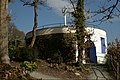
English: Rotunda lookout platform and Shell Grotto at Portmeirion, Gwynedd, Wales. Built 1954.
|
This is a category about listed building number 4896. |
Grade II listed building in Gwynedd. Set into the hillslope below Cliff House with panoramic views across the bay; accessed via steps and an arch from the main village road.  | |||||
| Upload media | |||||
| Instance of | |||||
|---|---|---|---|---|---|
| Location | Penrhyndeudraeth, Gwynedd, Wales | ||||
| Heritage designation | |||||
| Elevation above sea level |
| ||||
 | |||||
Media in category "Rotunda and grotto, Portmeirion"
The following 8 files are in this category, out of 8 total.
-
 Astrolabe on the Rotunda and Grotto - geograph.org.uk - 3085245.jpg 480 × 640; 135 KB
-
 Belvedere Outlook and Shell Grotto - geograph.org.uk - 1593164.jpg 640 × 480; 145 KB
-
 Cliff House from the Belvedere Outlook - geograph.org.uk - 1593116.jpg 480 × 640; 158 KB
-
 Cliff Top Rotunda (Grotto) - geograph.org.uk - 2573164.jpg 3,648 × 2,048; 1.96 MB
-
 Portmeirion 02319.jpg 502 × 670; 142 KB
-
 Portmeirion, Gwynedd - geograph.org.uk - 3364776.jpg 4,000 × 2,666; 6.6 MB
-
 Rotunda at Portmeirion.jpg 900 × 600; 115 KB
-
 Viewing Area, Portmeirion - geograph.org.uk - 2371436.jpg 1,024 × 683; 301 KB


_-_geograph.org.uk_-_2573164.jpg)


