Category:Ruins of Pauline monastery in Klastrompuszta
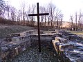
English: Ruins of Pauline monastery, A fenced ruin complex located about 4 km from the centre of the settlement, in the direction of southeast. From the buildings of the former monastery you can see a stretched, polygonally closed sanctuary with buttresses, a sacristy with a rectangular floor plan attached to the N wall of the sanctuary, and another part of the building connected to it, closed by five sides of the octagon. The remains of the wall are partially under a protective roof. The church and monastery built above the walls of the Árpád period at the end of the 14th or beginning of the 15th century. Probably around 1541-1543, were destroyed by fire. Listed. Part of the section 12 of National Blue Trail and a hiking chechpoint too. Part of the yellow Way of Mary (M21 (Pilisszentlélek – Pilisszentkereszt)), a montenbike route (green mtb (Pilisszántó – Klastrompuszta)) and a horse riding route (black horse (Pilisszántó – Klastrompuszta))- Klastrompuszta, Kesztölc, Komárom-Esztergom Co.
Magyar: Klastrompuszta, a pálos kolostor romjai. Korábbi épületek alpjaira a 14. sz. végén v. 15. sz elején épült. 'Kolostorrom' néven műemléki védelem alatt azonosító: 6282, törzsszám: 2494 Turistautak itt: kék OKT; sárga sáv S (Esztergom, vá. – Pilisvörösvár – Csíki csárda am.); fekete lovasút (Pilisszántó – Klastrompuszta), zöld mtb terepkerékpárút (Pilisszántó – Klastrompuszta), PB12 Pilisi bortúra; sárga Mária-út, M21 (Pilisszentlélek – Pilisszentkereszt), kék KΩ (Klastrompuszta – Legény-barlang) turistautak.openstreetmap.hu- Komárom-Esztergom m., Kesztölc, Klastrompuszta, helyrajzi szám: 0139/14, 0139/13
Media in category "Ruins of Pauline monastery in Klastrompuszta"
The following 4 files are in this category, out of 4 total.
-
 Klastrompuszta.jpg 5,152 × 3,864; 5.39 MB
-
 Pálos templomrom Klastrompusztán, légi fotó.jpg 600 × 400; 170 KB
-
 Ruins of Pauline monastery, Klastrompuszta 01.JPG 2,560 × 1,920; 3.36 MB
-
 Ruins of Pauline monastery, Klastrompuszta 02.JPG 2,560 × 1,920; 3.35 MB


