Category:SIR-C/X-SAR
NASA radar _-_DPLA_-_14a7fbe26f59c25baab525cb1d56f3ed.jpg) | |||||
| Upload media | |||||
| Instance of | |||||
|---|---|---|---|---|---|
| Operator | |||||
| |||||
Spaceborne Imaging Radar-C and X-Synthetic Aperture Radar (SIR-C/X-SAR) mission is part of the National Aeronautics and Space Administration (NASA) mission to planet earth, which began in 1991 to enhance our knowledge of the global environment. SIR-C/X-SAR data are improving our understanding of Earth's environment, including the global carbon cycle, the water cycle, climatic and geological processes, ocean circulation, and air-sea interactions. The multi-frequency SIR-C/X-SAR data, complemented by information from aircraft and ground studies, will give scientists clearer insights into environmental changes - those caused by nature as well as those induced by human activity.
SIR-C/X-SAR's radar waves penetrate clouds, and, under certain circumstances, can also penetrate vegetation., ice and dry sand. Acquiring data at night as well as during the day, the system allows scientists to make detailed studies of Earth's surface on a global scale, including new measurements such as biomass (surface plant material) and soil moisture.
A precursor to free-flyer satellite missions planned for later in the decade, SIR-C/X-SAR is the first spaceborne radar to simultaneously acquire data at multiple wavelengths and polarizations. The system is an evolution in technology for large-scale radar observations that began with Seasat in 1978 and continued with SIR-A in 1981 and SIR-B in 1984.
SIR-C was developed by NASA's Jet Propulsion Laboratory. X- SAR was developed by the Dornier and Alenia Spazio companies for the German space agency, Deutsche Agentur fuer Raumfahrtangelegenheiten (DARA), and the Italian space agency, Agenzia Spaziale Italiana (ASI).
Media in category "SIR-C/X-SAR"
The following 65 files are in this category, out of 65 total.
-
 Space radar image of Dublin.jpg 2,300 × 1,617; 1.32 MB
-
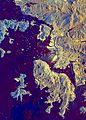
 Alcedo and Sierra Negra (Galapagos).jpg 768 × 525; 138 KB
-
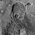
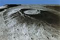
 Aorounga crater.png 500 × 398; 191 KB
-
 EndeavourPayloadBaySTS59.jpg 4,174 × 4,128; 1.96 MB
-
 Hong Kong from Space.jpg 1,792 × 2,496; 979 KB
-
 Kliuchevskoi Volcano eruption from space.jpg 2,254 × 2,248; 397 KB
-
 Klyuchevskaya sopka rad.jpg 816 × 576; 203 KB
-
 Kufra-space-radar.jpg 464 × 719; 94 KB
-
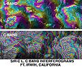 L C band topo interferograms.jpg 638 × 522; 90 KB
-
 Lake Palanskoye Landslide, Kamchatka Peninsula, Russia (cropped).jpg 446 × 200; 202 KB
-
 NASA RabaulVolcano PIA01767.jpg 853 × 993; 855 KB
-
 NASA Spaceborne radar image of Munich, Germany - 1994 hi res.jpg 2,466 × 2,881; 8.68 MB
-
 Oetztal-space-radar NASA PIA01760 md.jpg 600 × 452; 75 KB
-
 PIA01844 modest rotated.jpg 418 × 797; 121 KB
-
 Roter Kamm, PIA00503 md.jpg 2,896 × 2,032; 3.87 MB
-
 Roter kamm.gif 822 × 576; 434 KB
-
 Ruiz volcano.jpg 3,997 × 3,408; 3.33 MB
-
 SafsafOasis SAR comparison.jpg 540 × 588; 154 KB
-
 Sakura-jima from space.jpg 3,000 × 3,716; 3.15 MB
-
 SAR Kilauea topo interferogram.jpg 577 × 577; 152 KB
-
 SAR Kilauea.jpg 1,000 × 1,000; 333 KB
-
 Sarwaterp.jpg 548 × 748; 374 KB
-
 Sc-muar.gif 342 × 480; 188 KB
-
 Sc-wshdc.gif 504 × 487; 196 KB
-
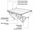 SIR-C X-SAR antenna.png 1,782 × 1,581; 51 KB
-
 SIR-C X-SAR Central Africa gorilla habitat in spring.jpg 990 × 2,655; 1.02 MB
-
 SIR-C X-SAR Central Africa gorilla habitat.jpg 916 × 807; 366 KB
-
 SIR-C X-SAR Electromagnetic spectrum.svg 816 × 1,239; 5 KB
-
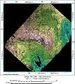
 SIR-C X-SAR image of Manaus, Brazil.jpg 1,049 × 2,815; 759 KB
-
 SIR-C X-SAR in the payload bay.jpg 3,022 × 3,018; 1.11 MB
-
 SIR-C X-SAR Kliuchevskoi Volcano.jpg 1,202 × 835; 392 KB
-
 SIR-C X-SAR Long Valley, California.jpg 1,383 × 1,540; 553 KB
-
 SIR-C X-SAR of Mount Pinatubo.jpg 2,395 × 2,435; 1.53 MB
-
 SIR-C X-SAR Raco, Michigan biomass map.jpg 741 × 1,353; 249 KB
-
 SIR-C X-SAR Raco, Michigan collage.jpg 2,428 × 2,806; 1.73 MB
-
 SIR-C X-SAR Raco, Michigan false color radar image.jpg 1,593 × 2,763; 1.22 MB
-
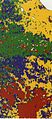 SIR-C X-SAR Raco, Michigan vegitation map.jpg 592 × 1,357; 192 KB
-
 SIR-C X-SAR Safsaf Oasis 2.jpg 1,038 × 1,232; 1.35 MB
-
 SIR-C X-SAR Safsaf Oasis comparison.jpg 2,100 × 1,232; 1.44 MB
-
 SIR-C X-SAR Safsaf Oasis.jpg 1,409 × 1,881; 871 KB
-
 SIR-C X-SAR Ubar, Oman.gif 537 × 1,000; 519 KB
-
 SIR-C X-SAR Weddell.gif 378 × 1,344; 582 KB
-
 SIR-C-X-SAR Death Valley Collage.jpg 2,125 × 1,423; 479 KB
-
 SIR-C-X-SAR Death Valley Elevations.jpg 1,042 × 425; 89 KB
-
 SIR-C-X-SAR Death Valley perspective.jpg 2,088 × 929; 275 KB
-
 SIR-C-X-SAR Death Valley Radar.jpg 1,014 × 424; 103 KB
-
 SIR-C-X-SAR Galapagos Alcedo NW.jpg 510 × 339; 60 KB
-
 SIR-C-X-SAR Galapagos collage.jpg 1,055 × 702; 184 KB
-
 SIR-C-X-SAR Galapagos Wolf Darwin.jpg 512 × 333; 39 KB
-
 SIR-C-X-SAR-Oberpfaffenhofen.jpg 1,410 × 1,886; 723 KB
-
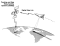 SIR-C-X-SAR-operations.png 1,873 × 1,439; 279 KB
-
 Space Radar Image of Lisbon, Portugal.jpg 4,000 × 2,392; 13.42 MB
-
 Space Radar Image of Taiwan.jpg 600 × 395; 50 KB
-
 Space radar image of Washington, D.C. DVIDS744627.jpg 1,536 × 1,376; 951 KB
-
 SRTM SIR-C vs X-SAR.png 1,616 × 942; 522 KB
-
 Stereo Pair, Lake Palanskoye Landslide, Kamchatka Peninsula, Russia.jpg 519 × 800; 583 KB
-
 Strasbourg SIR-C-X-SAR PIA01859.png 1,269 × 1,473; 1.57 MB
-
 STS-68 payload bay view.jpg 4,040 × 4,095; 2.91 MB
-
 STS068-267-079 Sunrise over Endeavour and SIR-C.jpg 4,018 × 4,096; 2.29 MB
-
 TEIDE.JPG 3,600 × 2,180; 1.89 MB
-
 TNF-NASAmap-Labels.png 720 × 436; 431 KB
-
 Topography of Bali.jpg 1,669 × 1,217; 498 KB
-
 Volcan Alcedo (Galapagos).jpg 768 × 518; 76 KB
-
 Volcanoes of Western Isabela.jpg 631 × 480; 99 KB
-
 Weddelleddy.jpg 435 × 325; 72 KB

.jpg)


.jpg)


.jpg)

