Category:SVG location maps of France
 |
This category should only contain blank "Location maps" created for geo-location purposes which follow a same uniform standard, and have been created with a Geographic information system (GIS) software program using a compatible equirectangular or conical projection and for which the geographic coordinate system is known. For more information or questions see the wikiproject: German Wikipedia:Kartenwerkstatt/Positionskarten and this discussion page. |

Subcategories
This category has the following 3 subcategories, out of 3 total.
*
Media in category "SVG location maps of France"
The following 35 files are in this category, out of 35 total.
-
 France blank 1.svg 1,796 × 1,797; 265 KB
-
 France blank 2.svg 1,796 × 1,797; 261 KB
-
 France blank.svg 1,796 × 1,797; 240 KB
-
 France blank1.svg 1,796 × 1,796; 1.09 MB
-
 France blank3.svg 1,796 × 1,796; 973 KB
-
 France location map-Regions and departements 1975-2014.svg 2,000 × 1,922; 753 KB
-
 France location map-Regions-2015 (numbered).svg 512 × 492; 457 KB
-
 France location map-Regions-2015.svg 2,000 × 1,922; 519 KB
-
 France location map.svg 1,041 × 997; 643 KB
-
 France South West location map.svg 859 × 838; 268 KB
-
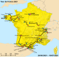 2021 Tour de France map.svg 2,385 × 2,292; 5.9 MB
-
 Carte Agence francaise pour la biodiversite.svg 2,000 × 1,922; 2.9 MB
-
 Carte topographique Tubuai.svg 1,510 × 860; 836 KB
-
 Comté de Champagne location map.svg 529 × 491; 957 KB
-
 Côte d’Azur location map.svg 3,689 × 2,281; 1.35 MB
-
 Départements et régions de France 2016.svg 588 × 550; 226 KB
-
 Départements et régions de France vide.svg 530 × 550; 215 KB
-
 Départements et régions de France2.svg 588 × 550; 262 KB
-
 France adm location map.svg 2,000 × 1,922; 524 KB
-
 France adm-2 location map.svg 2,000 × 1,922; 759 KB
-
 France location map – regions and departments (including overseas).svg 2,000 × 1,922; 1,005 KB
-
 France location map-1477-blank.svg 2,000 × 1,922; 820 KB
-
 France location map-Departements-2015+ROM.svg 2,000 × 1,922; 840 KB
-
 France location map-Departements-2015.svg 2,000 × 1,922; 783 KB
-
 France location map-Regions and departements-2015.svg 2,000 × 1,922; 699 KB
-
 France location map-Regions and departements-2016.svg 2,000 × 1,922; 551 KB
-
 France location map-Regions-2016.svg 2,000 × 1,922; 230 KB
-
 France map Lambert-93 topographic with regions and departements-blank.svg 2,000 × 1,898; 1.67 MB
-
 France map Lambert-93 topographic-demarcation line.svg 2,000 × 1,898; 1.57 MB
-

-
 Marquesas location map.svg 4,357 × 4,301; 2.67 MB
-
 Tour de France base map empty.svg 2,385 × 2,292; 5.87 MB
-
 Tour de France base map.svg 2,385 × 2,292; 5.85 MB
-
 Tuamotu relief location map.svg 1,797 × 1,319; 550 KB
-
 Îles Australes relief location map.svg 1,438 × 840; 150 KB

.svg)


.svg)


