Category:SVG locator maps of former countries of Asia (location map scheme)
Media in category "SVG locator maps of former countries of Asia (location map scheme)"
The following 23 files are in this category, out of 23 total.
-
 Emirate of Jabal Shammar 1873 Map.svg 356 × 212; 882 KB
-
 Emirate of Nejd and Hasa 1913.svg 355 × 212; 881 KB
-
 Emirate of Riyadh 1902.svg 356 × 212; 880 KB
-
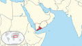 Federation of South Arabia in its region.svg 574 × 317; 6.96 MB
-
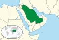
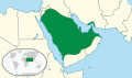 First Saudi State.svg 356 × 212; 880 KB
-
 Idrisid Emirate (1918 - 1924) Map.svg 448 × 267; 889 KB
-
 Idrisid Emirate of Asir 1932 Map.svg 448 × 267; 891 KB
-
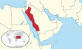 Kingdom of Hejaz 1920 Map.svg 512 × 306; 879 KB
-
 Kingdom of Hejaz and Nejd 1926.svg 361 × 227; 905 KB
-
 North and South Yemen in their region.svg 574 × 317; 7.21 MB
-
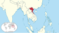 North Vietnam in its region.svg 617 × 342; 447 KB
-
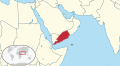
 North Yemen in its region.svg 574 × 317; 6.96 MB
-
 Second Saudi State.svg 356 × 212; 880 KB
-
 South Vietnam in its region.svg 617 × 342; 447 KB
-
 South Yemen in its region.svg 574 × 317; 6.96 MB
-
 Soviet Union in its region.svg 881 × 585; 4.6 MB
-
 Soviet Union on the globe (Soviet Union centered).svg 805 × 805; 412 KB
-
 State of Mahra in its region (1923).svg 1,162 × 1,225; 1.57 MB
-
 Sultanate of Nejd 1921.svg 335 × 227; 905 KB
-
 Tibet state in its region (claims).svg 450 × 253; 2.21 MB
-
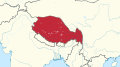 Tibet state in its region.svg 450 × 253; 2.18 MB
-
 USSR in EurAsia.svg 1,181 × 1,050; 5.72 MB
-
 Yemen in its region 1990-2000.svg 574 × 317; 6.96 MB


_Map.svg)


.svg)
.svg)

.svg)


