Category:SVG maps of regions of Colombia
Media in category "SVG maps of regions of Colombia"
The following 18 files are in this category, out of 18 total.
-
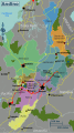 Andino regions map.svg 493 × 882; 7.04 MB
-
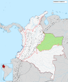
 Colombia regions map.svg 460 × 559; 1.59 MB
-
 Colombian Amazonia regions map.svg 970 × 793; 4.41 MB
-
 Colombian Islands regions map.svg 650 × 1,293; 1.15 MB
-
 Costa Norte regions map.svg 587 × 530; 5.84 MB
-
 División Subdepartamental de Colombia.svg 512 × 607; 3.02 MB
-
 Mapa de Colombia (corporaciones autónomas regionales).svg 1,420 × 1,896; 1.08 MB
-
 Mapa de Colombia (provincias).svg 1,420 × 1,896; 2.79 MB
-
 Mapa de Colombia (regiones naturales)-nn.svg 1,763 × 2,126; 1.48 MB
-
 Mapa de Colombia (regiones naturales).svg 1,763 × 2,126; 2.59 MB
-
 Mapa de Colombia (región Amazónica).svg 1,763 × 2,126; 1.45 MB
-
 Mapa de Colombia (región Andina).svg 1,763 × 2,126; 1.45 MB
-
 Mapa de Colombia (región de la Orinoquía).svg 1,763 × 2,126; 1.45 MB
-
 Mapa de Colombia (región del Caribe).svg 1,763 × 2,126; 1.45 MB
-
 Mapa de Colombia (región del Pacífico).svg 1,763 × 2,126; 1.46 MB
-
 Mapa de Colombia (región Insular).svg 1,763 × 2,126; 1.5 MB
-
 Orinoquía regions map.svg 701 × 526; 3.17 MB
-
 Pacifica regions map.svg 340 × 788; 4.31 MB


.svg)
.svg)
-nn.svg)
.svg)
.svg)
.svg)
.svg)
.svg)
.svg)
.svg)

