Category:SVG topographic maps of Indonesia
Media in category "SVG topographic maps of Indonesia"
The following 23 files are in this category, out of 23 total.
-
 Bali topographic map-id.svg 2,432 × 1,336; 11.95 MB
-
 Indonesia - Sumatra rotated - id.svg 445 × 326; 1.32 MB
-
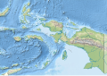 Indonesia Maluku-Western New Guinea rel location map.svg 1,472 × 1,033; 1.03 MB
-
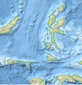 Indonesia North Maluku rel location map.svg 523 × 543; 1.32 MB
-
 Indonezija.svg 831 × 362; 1.99 MB
-
 Madura Island topographic map - ru.svg 2,401 × 806; 1.09 MB
-
 Minahassa Peninsula topographic map - id.svg 2,731 × 1,440; 3.97 MB
-
 Minahassa Peninsula topographic map - ru.svg 2,731 × 1,440; 4.51 MB
-
 Mursala dan Tapanuli Teluk peta topografi id.svg 1,720 × 1,191; 620 KB
-
 Nias peta topografi-id.svg 1,336 × 1,326; 2.04 MB
-
 North Kalimantan (Indonesia) topographic map - id.svg 1,557 × 1,473; 2.27 MB
-
 North Kalimantan (Indonesia) topographic map - ru.svg 1,557 × 1,473; 2.28 MB
-
 Peta Topografi Kabupaten Tanah Laut-Text.svg 1,054 × 745; 3.62 MB
-
 Peta Topografi Kabupaten Tanah Laut.svg 1,054 × 745; 3.54 MB
-
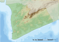
 Puncak Jaya topographic map-fr.svg 1,280 × 915; 1.22 MB
-
 Puncak Jaya topographic map-hu.svg 1,280 × 915; 868 KB
-
 Puncak Jaya topographic map-id.svg 1,280 × 915; 1.17 MB
-
 Puncak Jaya topographic map-mk.svg 1,280 × 915; 1.49 MB
-
 Sapudi Island topographic map - ru.svg 1,500 × 1,400; 473 KB
-
 Sumatra.svg 164 × 120; 1.31 MB
-
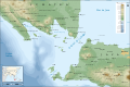
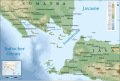 Sunda Strait map-de.svg 3,579 × 2,395; 2.05 MB
-
 Sunda Strait map-fr.svg 3,579 × 2,395; 2.08 MB
-
 Topographic map of Buru-en.svg 1,972 × 1,475; 1.14 MB


_topographic_map_-_id.svg)
_topographic_map_-_ru.svg)


