Category:Sahara Lommel
| Camera location | | View all coordinates using: OpenStreetMap |
|---|
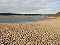
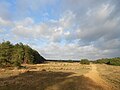
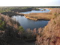
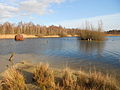
Nederlands: Afbeeldingen van het natuurgebied de Lommelse Sahara, Sportveldenstraat 10, Lommel. Gelegen in de gemeente Lommel in de provincie Limburg (Belgische provincie) in het noordoosten van België (bron [1];[2];[3];[4])
 | |||||
| Upload media | |||||
| Instance of | |||||
|---|---|---|---|---|---|
| Named after | |||||
| Location |
| ||||
| Area |
| ||||
 | |||||
Media in category "Sahara Lommel"
The following 45 files are in this category, out of 45 total.
-
 Lommel Sahara.jpg 299 × 156; 7 KB
-
 Lommelse Sahara (1).JPG 4,320 × 3,240; 3.05 MB
-
 Lommelse Sahara (10).JPG 4,320 × 3,240; 3.09 MB
-
 Lommelse Sahara (11).JPG 4,320 × 3,240; 3.07 MB
-
 Lommelse Sahara (12).JPG 4,320 × 3,240; 3.08 MB
-
 Lommelse Sahara (13).JPG 4,320 × 3,240; 3.04 MB
-
 Lommelse Sahara (14).JPG 4,320 × 3,240; 3.05 MB
-
 Lommelse Sahara (15).JPG 4,320 × 3,240; 3.11 MB
-
 Lommelse Sahara (16).JPG 4,320 × 3,240; 3.05 MB
-
 Lommelse Sahara (17).JPG 4,320 × 3,240; 3.05 MB
-
 Lommelse Sahara (18).JPG 4,320 × 3,240; 3.04 MB
-
 Lommelse Sahara (19).JPG 4,320 × 3,240; 3.03 MB
-
 Lommelse Sahara (2).JPG 4,320 × 3,240; 3.05 MB
-
 Lommelse Sahara (20).JPG 4,320 × 3,240; 3.08 MB
-
 Lommelse Sahara (21).JPG 4,320 × 3,240; 3.03 MB
-
 Lommelse Sahara (22).JPG 4,320 × 3,240; 3.11 MB
-
 Lommelse Sahara (23).JPG 4,320 × 3,240; 2.99 MB
-
 Lommelse Sahara (24).JPG 4,320 × 3,240; 3.14 MB
-
 Lommelse Sahara (25).JPG 4,320 × 3,240; 3.07 MB
-
 Lommelse Sahara (26).JPG 4,320 × 3,240; 3.07 MB
-
 Lommelse Sahara (27).JPG 4,320 × 3,240; 3.11 MB
-
 Lommelse Sahara (28).JPG 4,320 × 3,240; 3.14 MB
-
 Lommelse Sahara (29).JPG 4,320 × 3,240; 3.11 MB
-
 Lommelse Sahara (3) (cropped).JPG 4,320 × 2,862; 2.88 MB
-
 Lommelse Sahara (3).JPG 4,320 × 3,240; 3.06 MB
-
 Lommelse Sahara (30).JPG 4,320 × 3,240; 3.06 MB
-
 Lommelse Sahara (4).JPG 4,320 × 3,240; 3.08 MB
-
 Lommelse Sahara (5).JPG 4,320 × 3,240; 3.06 MB
-
 Lommelse Sahara (6).JPG 4,320 × 3,240; 3.08 MB
-
 Lommelse Sahara (7).JPG 4,320 × 3,240; 3.03 MB
-
 Lommelse Sahara (8).JPG 4,320 × 3,240; 3.11 MB
-
 Lommelse Sahara (9).JPG 4,320 × 3,240; 3.12 MB
-
 Lommelse Sahara Bosland.jpg 2,048 × 1,536; 1.08 MB
-
 Lommelse Sahara.jpg 110 × 195; 7 KB
-
 Lommese Sahara 01.JPG 3,648 × 2,736; 3.24 MB
-
 Lommese Sahara 02.JPG 3,648 × 2,736; 3.22 MB
-
 Lommese Sahara 03.JPG 3,648 × 2,736; 2.85 MB
-
 Lommese Sahara 04.JPG 3,648 × 2,736; 2.76 MB
-
 Lommese Sahara 05.jpg 3,648 × 2,543; 2.42 MB
-
 Natuurgebied de Sahara - panoramio - Jan Uyttebroeck.jpg 1,600 × 1,200; 442 KB
-
 Natuurgebied de Sahara - panoramio.jpg 1,600 × 1,200; 450 KB
-
 Sahara Lommel 1.JPG 2,272 × 1,704; 883 KB
-
 Sahara Lommel 2.JPG 2,272 × 1,704; 901 KB
-
 Sahara Lommel 3.JPG 2,272 × 1,704; 889 KB
-
 Sahara Lommel Bosland.jpg 1,153 × 2,048; 534 KB
.JPG)
.JPG)
.JPG)
.JPG)
.JPG)
.JPG)
.JPG)
.JPG)
.JPG)
.JPG)
.JPG)
.JPG)
.JPG)
.JPG)
.JPG)
.JPG)
.JPG)
.JPG)
.JPG)
.JPG)
.JPG)
.JPG)
_(cropped).JPG)
.JPG)
.JPG)
.JPG)
.JPG)
.JPG)
.JPG)
.JPG)
.JPG)


