Category:Saint Oswald of Northumbria Church (Kapfenberg)
| Object location | | View all coordinates using: OpenStreetMap |
|---|
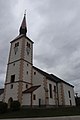
church building in Kapfenberg, Austria  | |||||
| Upload media | |||||
| Instance of | |||||
|---|---|---|---|---|---|
| Named after | |||||
| Location | Kapfenberg, Bruck-Mürzzuschlag District, Styria, Austria | ||||
| Street address |
| ||||
| Heritage designation | |||||
 | |||||
Subcategories
This category has only the following subcategory.
Media in category "Saint Oswald of Northumbria Church (Kapfenberg)"
The following 11 files are in this category, out of 11 total.
-

-
 Kapfenberg kosciol sw Oswalda 1.jpg 4,000 × 6,000; 4.63 MB
-
 Kapfenberg kosciol sw Oswalda 4.jpg 4,000 × 6,000; 7.28 MB
-
 Kapfenberg kosciol sw Oswalda 5.jpg 6,000 × 4,000; 7.16 MB
-
 Kapfenberg kosciol sw Oswalda 6.jpg 4,000 × 6,000; 4.7 MB
-
 Kapfenberg kosciol sw Oswalda 7.jpg 4,000 × 6,000; 5.33 MB
-
 Kirche Kapfenberg.jpg 960 × 1,280; 234 KB
-
 Kirche Sankt. Oswald in Kapfenberg.jpg 1,953 × 2,363; 971 KB
-
 Saint Oswald of Northumbria Church Kapfenberg 01.jpg 4,000 × 6,000; 9.85 MB
-
 Saint Oswald of Northumbria Church Kapfenberg 02.jpg 4,000 × 6,000; 12.13 MB
-
 St. Oswald in Kapfenberg.png 492 × 566; 425 KB
_der_Heilige,_Glasfenster_in_der_Kirche_St._Oswald_in_Kapfenberg.jpg)


