Category:Saint Stephen Church (Obermeisling)
| Object location | | View all coordinates using: OpenStreetMap |
|---|
| This category shows the protected monument with the number 69750 in Austria. (Commons, de, Wikidata) |
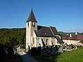
parish church  Parish church in Obermeisling, Lower Austria. | |||||
| Upload media | |||||
| Instance of | |||||
|---|---|---|---|---|---|
| Location | Gföhl, Krems District, Lower Austria, Austria | ||||
| Heritage designation | |||||
 | |||||
Media in category "Saint Stephen Church (Obermeisling)"
The following 7 files are in this category, out of 7 total.
-
 Obermeisling - Kirche.JPG 4,125 × 2,750; 9.75 MB
-
 Obermeisling Pfarrkirche Nordportal.jpg 2,736 × 3,648; 4.51 MB
-
 Obermeisling Pfarrkirche Schallfenster.jpg 3,648 × 2,736; 5.43 MB
-
 Obermeisling Pfarrkirche.jpg 3,648 × 2,736; 4.83 MB
-
 Pfarrkirche Obermeisling 01 2016-07.jpg 4,800 × 3,200; 5.49 MB
-
 Pfarrkirche Obermeisling 02 2016-07.jpg 4,800 × 3,200; 5.29 MB
-
 Pfarrkirche Obermeisling 03 2016-07.jpg 4,800 × 3,200; 5.17 MB


