Category:Sanborn Fire Insurance Map from Paw Paw, Lee County, Illinois
Media in category "Sanborn Fire Insurance Map from Paw Paw, Lee County, Illinois"
The following 12 files are in this category, out of 12 total.
-
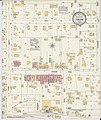
 Sanborn Fire Insurance Map from Paw Paw, Lee County, Illinois. LOC sanborn02083 001-1.jpg 6,450 × 7,650; 3.93 MB
-
 Sanborn Fire Insurance Map from Paw Paw, Lee County, Illinois. LOC sanborn02083 001-1.tif 6,450 × 7,650; 141.17 MB
-
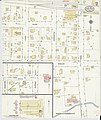
 Sanborn Fire Insurance Map from Paw Paw, Lee County, Illinois. LOC sanborn02083 001-2.jpg 6,450 × 7,650; 3.27 MB
-
 Sanborn Fire Insurance Map from Paw Paw, Lee County, Illinois. LOC sanborn02083 001-2.tif 6,450 × 7,650; 141.17 MB
-
-
 Sanborn Fire Insurance Map from Paw Paw, Lee County, Illinois. LOC sanborn02083 002-1.tif 6,450 × 7,650; 141.17 MB
-
 Sanborn Fire Insurance Map from Paw Paw, Lee County, Illinois. LOC sanborn02083 002-2.jpg 6,450 × 7,650; 3.52 MB
-
 Sanborn Fire Insurance Map from Paw Paw, Lee County, Illinois. LOC sanborn02083 002-2.tif 6,450 × 7,650; 141.17 MB
-
 Sanborn Fire Insurance Map from Paw Paw, Lee County, Illinois. LOC sanborn02083 003-1.jpg 6,450 × 7,650; 3.89 MB
-
 Sanborn Fire Insurance Map from Paw Paw, Lee County, Illinois. LOC sanborn02083 003-1.tif 6,450 × 7,650; 141.17 MB
-
 Sanborn Fire Insurance Map from Paw Paw, Lee County, Illinois. LOC sanborn02083 003-2.jpg 6,450 × 7,650; 3.66 MB
-
 Sanborn Fire Insurance Map from Paw Paw, Lee County, Illinois. LOC sanborn02083 003-2.tif 6,450 × 7,650; 141.17 MB


