Category:Sandfield Park, Liverpool
| Object location | | View all coordinates using: OpenStreetMap |
|---|
Sandfield Park was laid out about 1850 as a private residential park, intended for the more prosperous businessmen of Liverpool who found West Derby to be an ideal dormitory area.
Subcategories
This category has the following 4 subcategories, out of 4 total.
Media in category "Sandfield Park, Liverpool"
The following 10 files are in this category, out of 10 total.
-
 Benchmark at entrance to South Drive.jpg 4,418 × 3,324; 7.51 MB
-
 Churn stand north of Central Drive.jpg 4,991 × 3,167; 8.18 MB
-
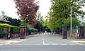 Entrance to Sandfield Park.jpg 5,024 × 2,994; 8.93 MB
-
 Queens Drive lodge at Sandfield Park.jpg 3,593 × 3,271; 6.14 MB
-
 Sandfield Park, Liverpool (1).JPG 3,240 × 4,320; 3.97 MB
-
 Sandfield Park, Liverpool (2).JPG 4,320 × 3,240; 4.94 MB
-
 Sandfield Park, Liverpool (3).JPG 4,320 × 3,240; 4.96 MB
-
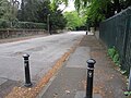
 View from North Drive bridge.jpg 3,864 × 5,152; 10.61 MB
-
 View N from Central Drive bridge.jpg 3,864 × 5,152; 10.64 MB
-
 View S from Central Drive bridge.jpg 3,864 × 5,152; 10.27 MB


.JPG)
.JPG)
.JPG)


