Category:Satellite pictures of Tatar Strait
Media in category "Satellite pictures of Tatar Strait"
The following 17 files are in this category, out of 17 total.
-
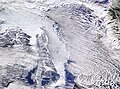 Cloud Streets and Sea Ice in Sea of Okhotsk (MODIS 2024-01-02).jpg 6,310 × 4,665; 4.38 MB
-
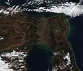
 Dust from the Gobi Desert over Russia (afternoon overpass) (MODIS 2016-03-13).jpg 4,600 × 6,000; 3.84 MB
-
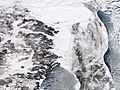
 Eastern Russia (MODIS 2021-01-05).jpg 4,688 × 3,957; 3.25 MB
-
 Ice breaking up in the Strait of Tartary (MODIS 2019-03-27).jpg 2,209 × 1,616; 704 KB
-
 Ice in Strait of Tartary, Russia (MODIS 2019-01-17).jpg 2,423 × 1,770; 886 KB
-
 Ice in the Strait of Tartary (MODIS 2024-03-09).jpg 2,111 × 1,583; 516 KB
-
 Ice in the Strait of Tartary (MODIS).jpg 1,695 × 1,344; 1.28 MB
-
 ISS-59 Russia, Strait of Tartary.jpg 5,568 × 3,712; 2.59 MB
-
 Sea Ice in the Gulf of Sakhalin and the Tartar Strait (MODIS 2020-02-19).jpg 2,898 × 2,367; 951 KB
-
 Sea Ice off Russia (MODIS 2020-01-01).jpg 4,399 × 3,755; 2.95 MB
-
 Sea Ice off Russia (MODIS 2022-04-07).jpg 6,020 × 4,814; 3.6 MB
-
 Sea Ice off Sakhalin Island, Russia (MODIS 2020-01-13).jpg 2,830 × 2,116; 924 KB
-
 Sediment in the Strait of Tartary (MODIS 2020-09-16).jpg 3,162 × 2,292; 478 KB
-
 Sediment in the Strait of Tartary (MODIS).jpg 1,738 × 1,332; 218 KB
-
 Smoke and Sediment in Russia's Far East (MODIS).jpg 2,861 × 2,154; 1.53 MB
-
 Strait of Tartary (MODIS 2018-11-04).jpg 2,499 × 2,146; 702 KB
-
 Пролив Невельского.jpg 349 × 256; 21 KB
.jpg)
_(MODIS_2016-03-13).jpg)
.jpg)
.jpg)
.jpg)
.jpg)
.jpg)

.jpg)
.jpg)
.jpg)
.jpg)
.jpg)
.jpg)
.jpg)
.jpg)
