Category:Satellite pictures of water vapor content
Media in category "Satellite pictures of water vapor content"
The following 19 files are in this category, out of 19 total.
-
 Atmospheric River GOES WV 20101220.1200.goes11.vapor.x.pacus.x.jpg 768 × 512; 217 KB
-
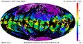 Atmospheric Water Vapor Mean.2005.030.jpg 2,431 × 1,280; 1.24 MB
-
 DesmondAtmosphericRiver.png 1,023 × 526; 596 KB
-
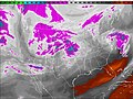 Feb 25 2008 water vapor usa.jpg 1,200 × 896; 346 KB
-
 German tornado May 2015 vapour.gif 640 × 420; 1.1 MB
-

-
GOES Water Vapor- 1995 Hurricane Season (SVS172).webm 1 min 36 s, 640 × 480; 19.59 MB
-
 GOES West Water Vapor.jpg 720 × 480; 88 KB
-
MYDAL2 M SKY WV.ogv 35 s, 472 × 316; 1.33 MB
-
 NHWV.JPG 640 × 480; 39 KB
-
 Noreasterwv.gif 720 × 480; 4.75 MB
-
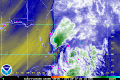
 North America water vapor May 5, 2010.jpg 515 × 455; 63 KB
-
 North American storm complex 2021 December 15 2150 UTC.jpg 1,920 × 1,080; 2.27 MB
-
 Powerful Winter Storm Takes Aim at Plains and Upper Midwest (32638477587).jpg 1,920 × 1,080; 499 KB
-
 Remnants of TS Philippe water vapor loop 29 Oct 2017.gif 720 × 480; 1.85 MB
-
 Satellite image of water vapor over Northern rockies March 19, 2020.jpg 1,200 × 1,200; 254 KB
-
 Total Precipitable Water Vapor on Cyclone Batsirai 2022-02-04.jpg 1,500 × 1,500; 299 KB
-
 TPWEastCoastLow.gif 640 × 480; 1.66 MB
-
 WaterVapor.jpg 553 × 600; 40 KB


.jpg)


.jpg)


