Category:Saucelle Dam
dam in the river Douro, province of Salamanca, Castile and León, Spain  | |||||
| Upload media | |||||
| Instance of | |||||
|---|---|---|---|---|---|
| Part of | |||||
| Location | Saucelle, Province of Salamanca, Castile and León, Spain | ||||
| Owned by | |||||
| Operator | |||||
| Inception |
| ||||
| Nominal power capacity |
| ||||
| Length |
| ||||
| Height |
| ||||
| Elevation above sea level |
| ||||
| Drainage basin | |||||
| Reservoir created | |||||
 | |||||
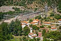
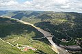
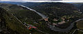
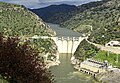
| The Saucelle Dam is a hydroelectric gravity dam on the Douro River, on the border between Spain and Portugal. |
Media in category "Saucelle Dam"
The following 13 files are in this category, out of 13 total.
-
 A barragem de Saucelle do miradouro de Penedo Durão edited.jpg 1,746 × 2,442; 5.48 MB
-
 A barragem de Saucelle do miradouro de Penedo Durão.jpg 3,696 × 2,448; 6.76 MB
-

-
 Central de Saucelle I.jpg 5,184 × 3,456; 12.66 MB
-
 Central de Saucelle II.jpg 5,184 × 3,456; 2.73 MB
-
 Detalle de la presa de Saucelle.jpg 5,184 × 2,724; 1.59 MB
-
 Embalse de Saucelle (27930035271).jpg 3,696 × 2,448; 4.97 MB
-
 Mirador de Penedo Durao.jpg 1,024 × 768; 224 KB
-
 Penedo Durão Douro Internacional PTCON0022.jpg 7,612 × 3,099; 14.24 MB
-
 Presa de Saucelle, 2017-08-31, CC0, 8002638.jpg 7,360 × 4,912; 14.81 MB
-
 Presa saucelle.jpg 640 × 960; 71 KB
-
 Salto saucelle.jpg 720 × 480; 83 KB
-
 Saucelle.jpg 3,968 × 2,736; 8.91 MB


_(123167519).jpg)


.jpg)


