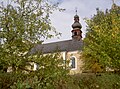
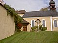
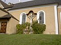
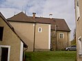
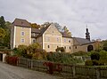
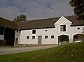
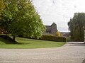
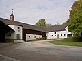
Category:Schloss Waffenbrunn
This is the category of the Bavarian Baudenkmal (cultural heritage monument) with the ID D-3-72-168-3 (Wikidata)
|
| Object location | | View all coordinates using: OpenStreetMap |
|---|
building in Waffenbrunn, Upper Palatinate, Germany  | |||||
| Upload media | |||||
| Instance of | |||||
|---|---|---|---|---|---|
| Location | Waffenbrunn, Cham, Upper Palatinate, Bavaria, Germany | ||||
| Street address |
| ||||
| Has part(s) |
| ||||
| Heritage designation | |||||
 | |||||
Media in category "Schloss Waffenbrunn"
The following 42 files are in this category, out of 42 total.
-
 Schloss Waffenbrunn.PNG 822 × 450; 1,002 KB
-
 Waffenbrunn Schloss-neu.jpg 1,884 × 1,339; 842 KB
-
 Waffenbrunn, CHA - Schlosskapelle v S 02.jpg 4,608 × 2,592; 1.34 MB
-
 Waffenbrunn-Schlosskapelle-02.JPG 4,592 × 2,576; 4.59 MB
-
 WaffenbrunnSchloss 01.jpg 2,304 × 1,704; 862 KB
-
 WaffenbrunnSchloss 02.jpg 2,304 × 1,704; 893 KB
-
 WaffenbrunnSchloss 03.jpg 2,304 × 1,704; 935 KB
-
 WaffenbrunnSchloss 04.jpg 2,304 × 1,704; 690 KB
-
 WaffenbrunnSchloss 05.jpg 2,304 × 1,704; 865 KB
-
 WaffenbrunnSchloss 06.jpg 2,304 × 1,704; 874 KB
-
 WaffenbrunnSchloss 07.jpg 2,304 × 1,704; 884 KB
-
 WaffenbrunnSchloss 08.jpg 2,304 × 1,704; 762 KB
-
 WaffenbrunnSchloss 09.jpg 2,304 × 1,704; 863 KB
-
 WaffenbrunnSchloss 10.jpg 2,304 × 1,704; 817 KB
-
 WaffenbrunnSchloss 11.jpg 2,304 × 1,704; 873 KB
-
 WaffenbrunnSchloss 12.jpg 2,304 × 1,704; 936 KB
-
 WaffenbrunnSchloss 13.jpg 2,304 × 1,704; 939 KB
-
 WaffenbrunnSchloss 14.jpg 2,304 × 1,704; 755 KB
-
 WaffenbrunnSchloss 15.jpg 2,304 × 1,704; 790 KB
-
 WaffenbrunnSchloss 16.jpg 2,304 × 1,704; 862 KB
-
 WaffenbrunnSchloss 17.jpg 2,304 × 1,704; 858 KB
-
 WaffenbrunnSchloss 18.jpg 2,304 × 1,704; 881 KB
-
 WaffenbrunnSchloss 19.jpg 2,304 × 1,704; 924 KB
-
 WaffenbrunnSchloss 20.jpg 2,304 × 1,704; 879 KB
-
 WaffenbrunnSchloss 21.jpg 2,304 × 1,704; 822 KB
-
 WaffenbrunnSchloss 22.jpg 2,304 × 1,704; 906 KB
-
 WaffenbrunnSchloss 23.jpg 2,304 × 1,704; 890 KB
-
 WaffenbrunnSchloss 24.jpg 2,304 × 1,704; 755 KB
-
 WaffenbrunnSchloss 25.jpg 2,304 × 1,704; 898 KB
-
 WaffenbrunnSchloss 26.jpg 2,304 × 1,704; 734 KB
-
 WaffenbrunnSchloss 27.jpg 2,304 × 1,704; 653 KB
-
 WaffenbrunnSchloss 28.jpg 2,304 × 1,704; 818 KB
-
 WaffenbrunnSchloss 29.jpg 2,304 × 1,704; 945 KB
-
 WaffenbrunnSchloss 30.jpg 2,304 × 1,704; 896 KB
-
 WaffenbrunnSchloss 31.jpg 2,304 × 1,704; 625 KB
-
 WaffenbrunnSchloss 32.jpg 2,304 × 1,704; 818 KB
-
 WaffenbrunnSchloss 33.jpg 2,304 × 1,704; 885 KB
-
 WaffenbrunnSchloss 34.jpg 2,304 × 1,704; 763 KB
-
 WaffenbrunnSchloss 35.jpg 2,304 × 1,704; 853 KB
-
 WaffenbrunnSchloss 36.jpg 2,304 × 1,704; 716 KB
-
 WaffenbrunnSchloss 37.jpg 2,304 × 1,704; 732 KB
-
 WaffenbrunnSchloss 38.jpg 2,304 × 1,704; 891 KB


