Category:Seil, Scotland
island on the east side of the Firth of Lorn, Argyll and Bute, Scotland, UK   | |||||
| Upload media | |||||
| Instance of | |||||
|---|---|---|---|---|---|
| Part of | |||||
| Location |
| ||||
| Located in or next to body of water | |||||
| Population |
| ||||
| Area |
| ||||
 | |||||
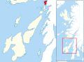
Seil (Scottish Gaelic: Saoil) is small island on the east side of the Firth of Lorn, 11 km southwest of Oban, in Scotland. It is one of the Slate Islands.
Subcategories
This category has the following 6 subcategories, out of 6 total.
C
- Clachan Bridge (84 F)
K
- Kilbrandon Church (38 F)
S
T
- Tigh an Truish Inn (23 F)
- Tin Church, Seil (2 F)
Media in category "Seil, Scotland"
The following 137 files are in this category, out of 137 total.
-
 'Innish' B^B at Clachan Bridge - geograph.org.uk - 4511990.jpg 3,264 × 2,448; 4.62 MB
-
 Admiralty Chart No 2063 Scotland - west coast - Easdale Sound, Published 1851.jpg 3,766 × 4,611; 3.73 MB
-
 Admiralty Chart No 2326 Loch Crinan to the Firth of Lorne (5413X8102), Published 1959.jpg 5,413 × 8,102; 14.28 MB
-
 Admiralty Chart No 2326 Loch Crinan to the Firth of Lorne, Published 1959.jpg 6,774 × 9,906; 25.95 MB
-
 Admiralty Chart No 2476 Frith of Lorn, Published 1856.jpg 8,269 × 14,016; 16.45 MB
-
 Admiralty Chart No 2476 Frith of Lorn, Published 1910.jpg 8,132 × 14,033; 12.28 MB
-
 An Cala, Seil (21762515544).jpg 5,472 × 3,648; 3.38 MB
-
 An Cala, Seil (21762529624).jpg 5,397 × 3,598; 6.46 MB
-
 An Cala, Seil (22197285920).jpg 5,472 × 3,648; 7.98 MB
-
 An Cala, Seil (22197291860).jpg 3,648 × 5,472; 8.46 MB
-
 An Cala, Seil (22372143952).jpg 3,647 × 3,647; 2.37 MB
-
 An Cala, Seil (22372149812).jpg 3,648 × 5,472; 6.94 MB
-
 An Cala, Seil (22396037071).jpg 5,472 × 3,648; 6.89 MB
-
 Ardea cinerea in Seil 01.JPG 3,264 × 2,448; 1.22 MB
-
 Ardea cinerea in Seil 02.JPG 3,264 × 2,448; 1.11 MB
-
 Ardencaple House, Isle of Seil - geograph.org.uk - 385544.jpg 640 × 479; 131 KB
-
 Ardencaple, Seil Island - 1971 - geograph.org.uk - 2950137.jpg 2,272 × 1,514; 485 KB
-
 Ardencaple, Seil Island - 1971 - geograph.org.uk - 2950701.jpg 2,272 × 1,515; 304 KB
-
 B844 at Oban Seil, Isle of Seil - geograph.org.uk - 5214533.jpg 1,600 × 1,065; 660 KB
-
 Ballachuan 060.JPG 2,816 × 1,584; 2.08 MB
-
 Ballachuan Loch - geograph.org.uk - 385903.jpg 640 × 477; 94 KB
-
 Ballachuan survey 011.JPG 2,272 × 1,704; 2.12 MB
-
 Ballachuan Wood - geograph.org.uk - 385836.jpg 640 × 479; 136 KB
-
 Balvicar Bay - geograph.org.uk - 110586.jpg 640 × 454; 42 KB
-
 Balvicar Bay - geograph.org.uk - 19584.jpg 640 × 425; 89 KB
-
 Barnafeochaig.jpg 3,264 × 2,448; 1.43 MB
-
 Bench in Seil.JPG 3,264 × 2,448; 1.33 MB
-
 Clachan Sound 01.JPG 3,143 × 2,357; 4.55 MB
-
 Clachan Sound 02.JPG 3,009 × 2,256; 4.96 MB
-
 Clachan Sound 03.JPG 3,264 × 2,448; 1.39 MB
-
 Clachan Sound 04.JPG 3,264 × 2,448; 1.34 MB
-
 Clachan Sound 05.JPG 3,264 × 2,448; 1.24 MB
-
 Cuan Ferry - geograph.org.uk - 1034905.jpg 640 × 427; 67 KB
-
 Cuan Ferry - geograph.org.uk - 1036126.jpg 640 × 427; 62 KB
-
 Cuan Ferry, Seil (geograph 5468155).jpg 1,024 × 768; 226 KB
-
 Easdale from the road.JPG 3,157 × 2,368; 3.67 MB
-
 Ellenabeich - geograph.org.uk - 95384.jpg 640 × 426; 115 KB
-
 Ferry slipway, Cuan Sound - geograph.org.uk - 733226.jpg 640 × 406; 75 KB
-
 Henderson's Rock - geograph.org.uk - 4167842.jpg 640 × 480; 421 KB
-
 Henderson's Rock - geograph.org.uk - 4167847.jpg 640 × 480; 467 KB
-
 Henderson's Rocks, Seil - geograph.org.uk - 290860.jpg 640 × 480; 69 KB
-
 In Nish, Clachan - geograph.org.uk - 5214122.jpg 1,600 × 1,065; 610 KB
-
 Innish from the 'Bridge over the Atlantic' - geograph.org.uk - 5403331.jpg 3,912 × 2,220; 1.02 MB
-
 Island of Seil, 1955 (1).jpg 3,123 × 1,395; 557 KB
-
 Island of Seil, 1955 (2).jpg 3,052 × 2,036; 1.05 MB
-
 Island of Seil, 1955 (3).jpg 2,984 × 2,048; 702 KB
-
 Island of Seil, 1955 (4).jpg 2,988 × 1,200; 484 KB
-
 Island of Seil, 1955 (5).jpg 3,136 × 2,113; 1.35 MB
-
 Island of Seil, 1955 (6).jpg 2,600 × 1,372; 521 KB
-
 Island of Seil, 1955 (7).jpg 3,084 × 2,016; 685 KB
-
 Island of Seil, 1955 (8).jpg 3,016 × 2,094; 1.23 MB
-
 Island of Seil, 1955 (9).jpg 3,095 × 1,615; 759 KB
-
 Isle of Seil - Slates with pyrite 01.JPG 3,264 × 2,448; 1.25 MB
-
 Isle of Seil - Slates with pyrite 02.JPG 3,264 × 2,448; 1.24 MB
-
 Isle of Seil - Slates with pyrite 03.JPG 3,264 × 2,448; 1.21 MB
-
 Isle of Seil - Slates with pyrite 04.JPG 3,264 × 2,448; 1.37 MB
-
 Isle of Seil 01.JPG 3,264 × 2,448; 1.42 MB
-
 Isle of Seil 02.JPG 3,264 × 2,448; 1.45 MB
-
 Isle of Seil 03.JPG 3,264 × 2,448; 1.16 MB
-
 Isle of Seil 04.JPG 3,264 × 2,448; 1.44 MB
-
 Isle of Seil 05.JPG 3,264 × 2,448; 1.16 MB
-
 Isle of Seil 06.JPG 3,264 × 2,448; 1.34 MB
-
 Isle of Seil 07.JPG 3,264 × 2,448; 1.41 MB
-
 Isle of Seil 08.JPG 3,264 × 2,448; 1.17 MB
-
 Luing - rocks and Seil.JPG 3,121 × 2,341; 4.37 MB
-
 Luing - sound between Luing and Seil.JPG 3,264 × 2,448; 1.27 MB
-
 Luing Ferry - geograph.org.uk - 168769.jpg 640 × 480; 194 KB
-
 Luing Ferry.jpg 640 × 476; 94 KB
-
 Luing from Seil.JPG 3,264 × 2,448; 1.31 MB
-
 Luing island from Seil island.JPG 3,264 × 2,448; 1.31 MB
-
 Maria Gastineau Part of island of Seil, Ben More in distance.jpg 500 × 329; 44 KB
-
 Meall a' Chaise - geograph.org.uk - 95390.jpg 640 × 424; 68 KB
-
 Nuagesryio.jpg 3,676 × 1,681; 2.84 MB
-
 Ordnance Survey One-inch Sheet 52 Loch Awe, Published 1956.jpg 8,604 × 10,703; 19.42 MB
-
 Ordnance Survey One-Inch Sheet 60 North Jura and Firth of Lorne, Published 1925.jpg 8,823 × 14,239; 11.94 MB
-
 Port a Mhuilinn - geograph.org.uk - 688.jpg 640 × 262; 22 KB
-
 Port a' Mhuilinn - geograph.org.uk - 4167977.jpg 640 × 480; 410 KB
-
 Port a' Mhuilinn - geograph.org.uk - 4471883.jpg 4,793 × 3,195; 5.17 MB
-
 Port a' Mhuilinn - geograph.org.uk - 4678277.jpg 1,600 × 1,200; 540 KB
-
 Port a'Mhuilinn, Seil - geograph.org.uk - 5468084.jpg 1,024 × 768; 235 KB
-
 Puilladobhrain Anchorage - geograph.org.uk - 4167808.jpg 640 × 480; 487 KB
-
 Puilladobhrain Anchorage - geograph.org.uk - 6213272.jpg 1,024 × 576; 85 KB
-
 Quay, Cuan - geograph.org.uk - 529472.jpg 640 × 480; 87 KB
-
 Rock outcrop on beach at Port a' Mhuilinn - geograph.org.uk - 4471909.jpg 4,697 × 2,905; 4.09 MB
-
-
 Scotland - Isle of Seil 01.JPG 3,264 × 2,448; 1.24 MB
-
 Scotland - Isle of Seil 02.JPG 3,264 × 2,448; 1.27 MB
-
 Scotland - Isle of Seil 03.JPG 3,264 × 2,448; 1.51 MB
-
 Scotland - Isle of Seil 04.JPG 2,448 × 3,264; 1.37 MB
-
 Scotland - Isle of Seil 05.JPG 3,264 × 2,448; 1.25 MB
-
 Scotland - Isle of Seil 06.JPG 3,264 × 2,448; 1.45 MB
-
 Scotland - Isle of Seil 07.JPG 3,264 × 2,448; 1.39 MB
-
 Scotland - Isle of Seil 08.JPG 3,264 × 2,448; 1.23 MB
-
 Scotland - Isle of Seil 09.JPG 2,448 × 3,264; 1.26 MB
-
 Scotland - Isle of Seil 10.JPG 3,264 × 2,448; 1.29 MB
-
 Scotland - Isle of Seil 11.JPG 3,264 × 2,448; 1.38 MB
-
 Scotland - Isle of Seil 12.JPG 3,264 × 2,448; 1.23 MB
-
 Scotland - Seil - cave.JPG 3,264 × 2,448; 1.31 MB
-
 Scotland - Seil 01.JPG 3,264 × 2,448; 1.38 MB
-
 Scotland - Seil 02.JPG 3,264 × 2,448; 1.32 MB
-
 Scotland - Seil 04.JPG 3,264 × 2,448; 1.2 MB
-
 Scotland - Seil 05.JPG 3,264 × 2,448; 1.29 MB
-
 Scotland - Seil 06.JPG 3,264 × 2,448; 1.23 MB
-
 Scotland - Seil 07.JPG 3,264 × 2,448; 1.28 MB
-
 Scotland - Seil 08.JPG 3,264 × 2,448; 1.56 MB
-
 Scotland - Seil 09.JPG 3,264 × 2,448; 1.4 MB
-
 Scotland - Seil 10.JPG 3,264 × 2,448; 1.35 MB
-
 Scotland - Seil 11.JPG 3,264 × 2,448; 1.37 MB
-
 Seil - abandonned sign.JPG 3,264 × 2,448; 1.31 MB
-
 Seil - Ballachuan Loch.JPG 3,264 × 2,448; 1.25 MB
-
 Seil - beach.JPG 3,190 × 2,393; 3.63 MB
-
 Seil - Lattice steel pylon.JPG 3,264 × 2,448; 1.22 MB
-
 Seil - pyrite cubes 01.JPG 3,264 × 2,448; 1.28 MB
-
 Seil - pyrite cubes 02.JPG 3,264 × 2,448; 1.26 MB
-
 Seil - pyrite cubes 03.JPG 3,264 × 2,448; 1.2 MB
-
 Seil - pyrite cubes 04.JPG 3,264 × 2,448; 1.37 MB
-
 Seil - pyrite cubes 05.JPG 3,264 × 2,448; 1.36 MB
-
 Seil - quarry at Easdale.JPG 3,264 × 2,448; 1.23 MB
-
 Seil - to Easdale.JPG 2,644 × 1,983; 2.82 MB
-
 Seil - to the West.JPG 3,264 × 2,448; 1.31 MB
-
 Seil - West coast.JPG 3,264 × 2,448; 1.34 MB
-
 Seil and Luing islands.JPG 3,264 × 2,448; 1.42 MB
-
 Seil in Southern Argyll.svg 885 × 655; 3.56 MB
-
 Seil off Oban, Argyllshire.svg 311 × 371; 4.27 MB
-
 Seil seen from Luing.JPG 3,264 × 2,448; 1.44 MB
-
 Seill.jpg 640 × 480; 69 KB
-
 Semi-open top bus approaching Easdale - geograph.org.uk - 2086098.jpg 640 × 425; 304 KB
-
 Siel 27998.jpg 3,200 × 1,771; 1.39 MB
-
 Sloc Nan Uan - geograph.org.uk - 95127.jpg 640 × 411; 114 KB
-
 South from Seil - geograph.org.uk - 22306.jpg 640 × 480; 92 KB
-
 Steep climb at Kilbride - geograph.org.uk - 5929988.jpg 1,024 × 768; 116 KB
-
 Sunrise over Seil - geograph.org.uk - 1129272.jpg 640 × 480; 72 KB
-
 Symmetry (35917422852).jpg 3,543 × 2,446; 7.79 MB
-
 The Cuan ferry at Luing - geograph.org.uk - 1509263.jpg 640 × 426; 228 KB
-
-
 West coast of Seil - geograph.org.uk - 4167941.jpg 640 × 480; 486 KB
-
 Whitewashed cottages at Ellenabeich - geograph.org.uk - 158872.jpg 640 × 427; 52 KB


,_Published_1959.jpg)


.jpg)
.jpg)
.jpg)
.jpg)
.jpg)
.jpg)
.jpg)


.jpg)


.jpg)
.jpg)
.jpg)
.jpg)
.jpg)
.jpg)
.jpg)
.jpg)


.jpg)


.jpg)