Category:Sept-Îles lighthouse
| Object location | | View all coordinates using: OpenStreetMap |
|---|
|
This building is indexed in the base Mérimée, a database of architectural heritage maintained by the French Ministry of Culture, under the reference IA22001257
|
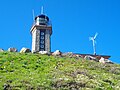
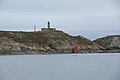
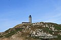
lighthouse in Côtes-d'Armor, France  | |||||
| Upload media | |||||
| Instance of | |||||
|---|---|---|---|---|---|
| Location | Perros-Guirec, Côtes-d'Armor, Brittany, Q88521114, Metropolitan France, France | ||||
| Heritage designation | |||||
| Service entry |
| ||||
| Inception |
| ||||
| Significant event |
| ||||
| Height |
| ||||
 | |||||
Media in category "Sept-Îles lighthouse"
The following 10 files are in this category, out of 10 total.
-
 Ile aux moines4158.JPG 2,736 × 3,648; 4 MB
-
 Ile aux moines4176.JPG 3,648 × 2,736; 4.09 MB
-
 Ile aux moines4182.JPG 3,648 × 2,736; 4.27 MB
-
 Ilesaux moines4179.JPG 2,736 × 3,648; 4.11 MB
-
 Le phare 7 Îles.jpg 3,408 × 2,272; 2.2 MB
-
 Moines05.JPG 3,648 × 2,736; 3.31 MB
-
 Phare des Sept-Îles.jpg 4,288 × 2,848; 4.96 MB
-
 Sept-Iles0059.jpg 4,608 × 3,456; 4.15 MB
-
 Sept-Iles0060.jpg 3,241 × 2,779; 2.18 MB
-
 Sept-Îles - Phare des Sept-Îles.jpg 4,272 × 2,848; 4.62 MB


