Category:Seringveld
| Object location | | View all coordinates using: OpenStreetMap |
|---|
Afrikaans: Seringveld is 'n gebied noordoos van Pretoria wat die Seringveld Bewarea insluit.
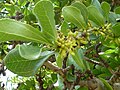
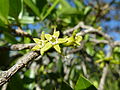
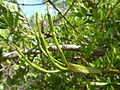
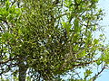
English: Seringveld is a rural region northeast of Pretoria, South Africa, that includes the Seringveld Conservancy. It is situated to the southeast of Dinokeng Game Reserve, and flanks the upper reaches of the Boekenhout Spruit.
A region near Pretoria, South Africa | |||||
| Upload media | |||||
 | |||||
Subcategories
This category has the following 3 subcategories, out of 3 total.
A
B
- Boekenhout Spruit (7 F)
Media in category "Seringveld"
The following 46 files are in this category, out of 46 total.
-
 Agelanthus natalitius subsp zeyheri, a, Seringveld.jpg 4,000 × 3,000; 3.8 MB
-
 Agelanthus natalitius subsp zeyheri, b, Seringveld.jpg 4,000 × 3,000; 3.72 MB
-
 Agelanthus natalitius subsp zeyheri, c, Seringveld.jpg 4,000 × 3,000; 4.5 MB
-
 Agelanthus natalitius subsp zeyheri, d, Seringveld.jpg 4,000 × 3,000; 4.34 MB
-
 Agelanthus natalitius subsp zeyheri, e, Seringveld.jpg 4,000 × 3,000; 4.41 MB
-
 Agelanthus natalitius subsp zeyheri, f, Seringveld.jpg 4,000 × 3,000; 3.86 MB
-
 Agelanthus natalitius subsp zeyheri, g, Seringveld.jpg 4,000 × 3,000; 3.81 MB
-
 Agelanthus natalitius subsp zeyheri, habitus, Seringveld.jpg 2,553 × 2,414; 2.44 MB
-
 Burkea africana, Seringveld.jpg 4,000 × 3,000; 4.61 MB
-
 Clutia pulchella, blomme, Seringveld.jpg 4,000 × 3,000; 3.25 MB
-
 Clutia pulchella, habitus, Seringveld.jpg 4,000 × 3,000; 4.94 MB
-
 Clutia pulchella, loof en blomknoppe, a, Seringveld.jpg 4,000 × 3,000; 3.58 MB
-
 Clutia pulchella, loof en blomknoppe, b, Seringveld.jpg 4,000 × 3,000; 3.57 MB
-
 Clutia pulchella, loof en blomme, Seringveld.jpg 3,300 × 3,000; 3 MB
-
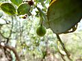
 Dovyalis zeyheri, jong vrugte, a, Seringveld.jpg 4,000 × 3,000; 3.66 MB
-
 Dovyalis zeyheri, jong vrugte, b, Seringveld.jpg 4,000 × 3,000; 3.58 MB
-
 Dovyalis zeyheri, jong vrugte, c, Seringveld.jpg 4,000 × 3,000; 3.87 MB
-
 Dovyalis zeyheri, jong vrugte, d, Seringveld.jpg 4,000 × 3,000; 3.55 MB
-
 Kiggelaria africana, manlike blom, Seringveld.jpg 3,187 × 2,822; 3.12 MB
-
 Kiggelaria africana, manlike blomme, a, Seringveld.jpg 3,077 × 2,631; 1.46 MB
-
 Kiggelaria africana, manlike blomme, b, Seringveld.jpg 3,513 × 3,000; 2.88 MB
-
 Osyris lanceolata, blomme, a, Seringveld.jpg 4,000 × 3,000; 2.95 MB
-
 Osyris lanceolata, blomme, b, Seringveld.jpg 3,132 × 2,413; 2 MB
-
 Osyris lanceolata, loof en blomme, a, Seringveld.jpg 4,000 × 3,000; 4.39 MB
-
 Osyris lanceolata, loof en blomme, b, Seringveld.jpg 4,000 × 3,000; 3.97 MB
-
 Osyris lanceolata, loof en blomme, c, Seringveld.jpg 4,000 × 3,000; 3.88 MB
-
 Osyris lanceolata, loof en blomme, d, Seringveld.jpg 4,000 × 3,000; 4.44 MB
-
 Osyris lanceolata, loof en vrug, a, Seringveld.jpg 2,846 × 2,762; 2.52 MB
-
 Osyris lanceolata, loof en vrug, b, Seringveld.jpg 4,000 × 3,000; 4.88 MB
-
 Pappea capensis, saailing, Seringveld.jpg 3,799 × 2,948; 3.67 MB
-
 Psydrax livida, bloeiwyses, a, Seringveld.jpg 2,392 × 2,822; 2.16 MB
-
 Psydrax livida, bloeiwyses, b, Seringveld.jpg 4,000 × 3,000; 4.77 MB
-
 Psydrax livida, habitus, Seringveld.jpg 3,000 × 4,000; 4.96 MB
-
 Psydrax livida, jong vrugte, a, Seringveld.jpg 4,000 × 3,000; 4.54 MB
-
 Psydrax livida, jong vrugte, b, Seringveld.jpg 4,000 × 3,000; 4.56 MB
-
 Psydrax livida, jong vrugte, c, Seringveld.jpg 4,000 × 3,000; 4.52 MB
-
 Psydrax livida, jong vrugte, d, Seringveld.jpg 4,000 × 3,000; 4.25 MB
-
 Psydrax livida, loof en jong vrugte, Seringveld.jpg 4,000 × 3,000; 4.64 MB
-
 Strychnos madagascariensis, blomme en jong vrugte, a, Seringveld.jpg 4,000 × 3,000; 4.17 MB
-
 Strychnos madagascariensis, blomme en jong vrugte, b, Seringveld.jpg 4,000 × 3,000; 4.59 MB
-
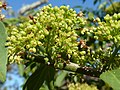
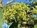
 Strychnos pungens, blomme, a, Seringveld.jpg 4,000 × 3,000; 4.7 MB
-
 Strychnos pungens, blomme, b, Seringveld.jpg 4,000 × 3,000; 4.6 MB
-
 Terminalia sericea, a, Seringveld.jpg 3,606 × 3,000; 3.6 MB
-
 Terminalia sericea, b, Seringveld.jpg 3,322 × 3,000; 3.28 MB
-
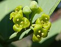
 Viscum combreticola, a, Seringveld.jpg 4,000 × 3,000; 4.46 MB
-
 Viscum combreticola, b, Seringveld.jpg 4,000 × 3,000; 4.99 MB


