Category:Sgùrr nan Ceathreamhnan
1151m high mountain in Highland, Scotland, UK  | |||||
| Upload media | |||||
| Instance of | |||||
|---|---|---|---|---|---|
| Part of |
| ||||
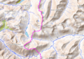
| Location | Highland, Scottish Highlands, Scotland | ||||
| Topographic prominence |
| ||||
| Elevation above sea level |
| ||||
 | |||||
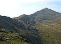
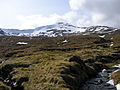
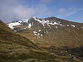
Sgùrr nan Ceathreamhnan is a mountain in the Highlands of Scotland. It is located on the northern side of the upper reaches of Glen Affric. It is 1151 m high, and listed as a Munro and a Marilyn.
Media in category "Sgùrr nan Ceathreamhnan"
The following 37 files are in this category, out of 37 total.
-

-

-
 Coire Lochan - geograph.org.uk - 5132999.jpg 1,024 × 751; 169 KB
-

-
 Creag nan Clachan Geala - geograph.org.uk - 5132993.jpg 1,024 × 706; 146 KB
-
 East ridge of Sgurr nan Ceathreamhnan - geograph.org.uk - 121256.jpg 640 × 465; 68 KB
-
 North side of Ciste Dhubh - geograph.org.uk - 1358386.jpg 640 × 480; 68 KB
-

-

-

-
 Ridge westwards from An Socach - geograph.org.uk - 1319360.jpg 640 × 424; 102 KB
-
 Sgurr nan Ceathreamhnan - geograph.org.uk - 121218.jpg 640 × 467; 73 KB
-
 Sgurr nan Ceathreamhnan from Mam Sodhail.jpg 1,727 × 1,232; 97 KB
-
 Sgurr nan Ceathreamhnan from the north - Flickr - Graham Grinner Lewis.jpg 2,048 × 1,536; 628 KB
-
 Sgurr nan Ceathreamhnan from the south - Flickr - Graham Grinner Lewis.jpg 2,048 × 1,536; 659 KB
-
 Sgurr nan Ceathreamhnan from the West top - panoramio.jpg 2,560 × 1,920; 2.43 MB
-
 Sgurr nan Ceathreamhnan west top - geograph.org.uk - 1547644.jpg 440 × 640; 108 KB
-
 Sgùrr Gaorsaic, seen from Beinn Fhada - geograph.org.uk - 1778812.jpg 800 × 600; 174 KB
-
 Sgùrr nan Ceathreamhnan - geograph.org.uk - 1005454.jpg 800 × 600; 175 KB
-

-
 Sgùrr nan Ceathreamhnan.png 1,874 × 1,324; 4.43 MB
-

-
 Summit cairn, Mullach na Dheiragain - geograph.org.uk - 1727501.jpg 800 × 533; 116 KB
-

-
 The Big Glens - geograph.org.uk - 121381.jpg 640 × 452; 52 KB
-
 The ridge to Mullach na Dheiragain - geograph.org.uk - 1552084.jpg 640 × 440; 74 KB
-

-
 The winter face of Sgurr nan Ceathramhnan - geograph.org.uk - 5132989.jpg 1,024 × 730; 133 KB
-
 Two Munros, FiveTops - geograph.org.uk - 883199.jpg 640 × 480; 69 KB
-
 View east from A' Ghlas-bheinn - geograph.org.uk - 641122.jpg 640 × 459; 56 KB
-
 View north from Druim Shionnach - geograph.org.uk - 1598653.jpg 800 × 600; 186 KB
-
 View towards Sgùrr nan Ceathreamhnan - geograph.org.uk - 1041813.jpg 800 × 600; 209 KB
-
 View towards Sgùrr nan Ceathreamhnan - geograph.org.uk - 1713456.jpg 800 × 600; 139 KB
-

-
 West top from Sgurr nan Ceathreamhnan - panoramio.jpg 2,560 × 1,920; 2.42 MB
-
 Carn an Con Dhu - geograph.org.uk - 1459298.jpg 640 × 480; 87 KB
-


