Category:Shackelford County, Texas
Counties of Texas: Anderson · Andrews · Angelina · Aransas · Archer · Armstrong · Atascosa · Austin · Bailey · Bandera · Bastrop · Baylor · Bee · Bell · Bexar · Blanco · Borden · Bosque · Bowie · Brazoria · Brazos · Brewster · Briscoe · Brooks · Brown · Buchel · Burleson · Burnet · Caldwell · Calhoun · Callahan · Cameron · Camp · Carson · Cass · Castro · Chambers · Cherokee · Childress · Clay · Cochran · Coke · Coleman · Collin · Collingsworth · Colorado · Comal · Comanche · Concho · Cooke · Coryell · Cottle · Crane · Crockett · Crosby · Culberson · Dallam · Dallas · Dawson · Deaf Smith · Delta · Denton · DeWitt · Dickens · Dimmit · Donley · Duval · Eastland · Ector · Edwards · El Paso · Ellis · Erath · Falls · Fannin · Fayette · Fisher · Floyd · Foard · Foley · Fort Bend
· Franklin · Freestone · Frio · Gaines · Galveston · Garza · Gillespie · Glasscock · Goliad · Gonzales · Gray · Grayson · Gregg · Grimes · Guadalupe · Hale · Hall · Hamilton · Hansford · Hardeman · Hardin · Harris · Harrison · Hartley · Haskell · Hays · Hemphill · Henderson · Hidalgo · Hill · Hockley · Hood · Hopkins · Houston · Howard · Hudspeth · Hunt · Hutchinson · Irion · Jack · Jackson · Jasper · Jeff Davis · Jefferson · Jim Hogg · Jim Wells · Johnson · Jones · Karnes · Kaufman · Kendall · Kenedy · Kent · Kerr · Kimble · King · Kinney · Kleberg · Knox · La Salle · Lamar · Lamb · Lampasas · Lavaca · Lee · Leon · Liberty · Limestone · Lipscomb · Live Oak · Llano · Loving · Lubbock · Lynn · Madison · Marion · Martin · Mason · Matagorda · Maverick · McCulloch · McLennan · McMullen · Medina · Menard · Midland · Milam · Mills · Mitchell · Montague · Montgomery · Moore · Morris · Motley · Nacogdoches · Navarro · Newton · Nolan · Nueces · Ochiltree · Oldham · Orange · Palo Pinto · Panola · Parker · Parmer · Pecos · Polk · Potter · Presidio · Rains · Randall · Reagan · Real · Red River · Reeves · Refugio · Roberts · Robertson · Rockwall · Runnels · Rusk · Sabine · San Augustine · San Jacinto · San Patricio · San Saba · Schleicher · Scurry · Shackelford · Shelby · Sherman · Smith · Somervell · Starr · Stephens · Sterling · Stonewall · Sutton · Swisher · Tarrant · Taylor · Terrell · Terry · Throckmorton · Titus · Tom Green · Travis · Trinity · Tyler · Upshur · Upton · Uvalde · Val Verde · Van Zandt · Victoria · Walker · Waller · Ward · Washington · Webb · Wharton · Wheeler · Wichita · Wilbarger · Willacy · Williamson · Wilson · Winkler · Wise · Wood · Worth · Yoakum · Young · Zapata · Zavala
English: Shackelford County, Texas is a county in the U.S. state of Texas.
county in Texas, United States   | |||||
| Upload media | |||||
| Instance of | |||||
|---|---|---|---|---|---|
| Named after |
| ||||
| Location | Texas | ||||
| Capital | |||||
| Inception |
| ||||
| Population |
| ||||
| Area |
| ||||
| official website | |||||
 | |||||
Subcategories
This category has the following 5 subcategories, out of 5 total.
A
M
Media in category "Shackelford County, Texas"
The following 10 files are in this category, out of 10 total.
-
-
 Dead man's Creek, Shackleford County - Winter. (11404986736).jpg 771 × 1,000; 684 KB
-
 Dr. 'Jack' Shackelford.jpg 191 × 275; 12 KB
-

-
 Lueders02 street.jpg 1,010 × 666; 137 KB
-
 Map of Texas highlighting Shackelford County.svg 12,473 × 11,855; 304 KB
-
 Nodding Donkey Pump Yard in Texas.jpg 2,419 × 1,361; 3.49 MB
-

-
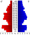 USA Shackelford County, Texas age pyramid.svg 520 × 600; 7 KB
-
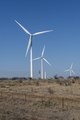 Wind turbines in Shackelford County, Texas, northeast of Abilene LCCN2014631722.tif 4,912 × 7,360; 206.9 MB
.jpg)


