Category:Shepaug Dam
| Object location | | View all coordinates using: OpenStreetMap |
|---|
| Upload media | |||||
| Instance of | |||||
|---|---|---|---|---|---|
| Location | Connecticut | ||||
| Drainage basin |
| ||||
| Reservoir created | |||||
 | |||||
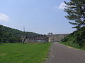
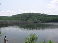
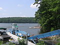
English: Media pertaining to the Shepaug Dam that impounds the Housatonic and Shepaug Rivers in Fairfield and Litchfield Counties in Connecticut, United States forming Lake Lillinonah

Media in category "Shepaug Dam"
The following 11 files are in this category, out of 11 total.
-
 LillinonahTrail SouthernLakeWithDam.JPG 2,048 × 1,536; 1.8 MB
-
 LillinonahTrail SouthernLakeWithDam2.jpg 1,536 × 2,048; 1.7 MB
-
 LillinonahTrail SouthernLakeWithDamAndBuoys.JPG 2,048 × 1,536; 1.45 MB
-
 Shepaug Dam 012.JPG 2,048 × 1,536; 831 KB
-
 Shepaug Dam 013.JPG 2,048 × 1,536; 1 MB
-
 Shepaug Dam 014.JPG 2,048 × 1,536; 992 KB
-
 Shepaug Dam 016.JPG 2,048 × 1,536; 772 KB
-
 Shepaug Dam 017.JPG 1,536 × 2,048; 874 KB
-
 Shepaug Dam powerhouse 018.JPG 2,048 × 1,536; 955 KB
-
 Shepaug powerhouse 019.JPG 2,048 × 1,536; 1.21 MB
-
 Shepaug River mouth at dam 015.JPG 2,048 × 1,536; 1.06 MB


