Category:Shropshire Union Canal
English:
Main Wikipedia article: Shropshire Union Canal.

canal in North West England  | |||||
| Upload media | |||||
| Instance of | |||||
|---|---|---|---|---|---|
| Location |
| ||||
 | |||||
Subcategories
This category has the following 19 subcategories, out of 19 total.
A
- Autherley Junction (20 F)
B
- Barbridge Junction (31 F)
- Betton Mill (17 F)
C
- Cowley Tunnel (39 F)
L
M
- Mollington Viaduct (4 F)
N
- Nantwich Aqueduct (23 F)
- Norbury Junction (44 F)
P
S
- Shroppie Fly, Audlem (18 F)
- Stretton Aqueduct (13 F)
Media in category "Shropshire Union Canal"
The following 200 files are in this category, out of 617 total.
(previous page) (next page)-
 'Maiden' at Market Drayton - geograph.org.uk - 516815.jpg 640 × 428; 91 KB
-
 'The Shroppie' south of Watling Street - geograph.org.uk - 965280.jpg 640 × 480; 110 KB
-
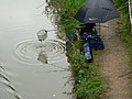
 A barbie by the cut - geograph.org.uk - 1605259.jpg 640 × 479; 142 KB
-

-
 A sunny day on the Shropshire Union - geograph.org.uk - 832720.jpg 640 × 480; 77 KB
-
 A wintery scene from The White House - geograph.org.uk - 81404.jpg 640 × 480; 118 KB
-
 Above Bunbury Locks - geograph.org.uk - 129544.jpg 640 × 429; 87 KB
-
 Acton Bridge north-west of Nantwich in Cheshire - geograph.org.uk - 5518347.jpg 1,280 × 908; 906 KB
-
 Acton Bridge north-west of Nantwich in Cheshire - geograph.org.uk - 5518352.jpg 1,280 × 944; 958 KB
-
 Acton Bridge north-west of Nantwich in Cheshire - geograph.org.uk - 5519054.jpg 1,280 × 960; 928 KB
-
 Along the towpath on NCR's 5 & 56 - geograph.org.uk - 1442829.jpg 640 × 426; 452 KB
-
 Another bridge by Thomas Telford - geograph.org.uk - 857173.jpg 640 × 480; 65 KB
-

-
 Approaching Pendeford Bridge - geograph.org.uk - 940258.jpg 640 × 480; 76 KB
-

-
 Approaching Tyrley Wharf, Shropshire - geograph.org.uk - 1590649.jpg 640 × 480; 144 KB
-
 Aqueduct on the Shropshire Union - geograph.org.uk - 787407.jpg 640 × 480; 306 KB
-
 At the water's edge - geograph.org.uk - 1605485.jpg 473 × 640; 148 KB
-
 Audlem Mill, Cheshire - geograph.org.uk - 1330906.jpg 472 × 640; 161 KB
-

-
 Audlem03LB.jpg 4,608 × 3,456; 6.75 MB
-
 Autumn tints in Brownhills Wood - geograph.org.uk - 257647.jpg 604 × 579; 219 KB
-
 Baddington, valley of Edleston Brook - geograph.org.uk - 264140.jpg 640 × 480; 121 KB
-
 The Shropshire Union Canal - geograph.org.uk - 1452193.jpg 640 × 480; 57 KB
-

-
 Beside the basin - geograph.org.uk - 792510.jpg 640 × 480; 86 KB
-

-

-
 Boat Inn, Gnosall Heath - geograph.org.uk - 516914.jpg 640 × 428; 95 KB
-
 Boat Maintenance Workshop, Norbury Junction.jpg 3,264 × 2,448; 1.66 MB
-

-
 Boaters on the Canal - geograph.org.uk - 1458566.jpg 521 × 640; 64 KB
-
 Boats moored at Nantwich Marina - geograph.org.uk - 701896.jpg 640 × 428; 160 KB
-

-
-

-
 (Im)mobile homes - geograph.org.uk - 737512.jpg 640 × 480; 70 KB
-
 Brewood and Coven - Shropshire Union Canal Number 13 (School Bridge) - 20230826091831.jpeg 4,032 × 3,024; 3.12 MB
-
 Brewood and Coven - Shropshire Union Canal Number 13 (School Bridge) - 20230826091901.jpeg 4,032 × 3,024; 5.56 MB
-
 Brewood canal north.JPG 2,736 × 3,648; 4.32 MB
-
 Brewood canal south.JPG 3,648 × 2,736; 4.46 MB
-

-

-

-
 Buildings at Tyrley Wharf.jpg 640 × 427; 84 KB
-

-
 Cadbury Wharf, Knighton, Staffordshire - geograph.org.uk - 1321957.jpg 575 × 640; 139 KB
-
 Cadbury Wharf, Knighton, Staffordshire - geograph.org.uk - 547853.jpg 640 × 474; 133 KB
-
 Calveley - geograph.org.uk - 3120.jpg 640 × 480; 45 KB
-
 Calveley - Shropshire Union Canal.jpg 640 × 429; 85 KB
-
 Canal and evening Sun. - geograph.org.uk - 422031.jpg 640 × 480; 89 KB
-
 Canal and farmland near Burford, Cheshire - geograph.org.uk - 5518343.jpg 1,280 × 879; 1.21 MB
-

-
 Canal at Gnosall Heath - geograph.org.uk - 182409.jpg 640 × 480; 123 KB
-
 Canal at Gnosall Heath - geograph.org.uk - 187788.jpg 640 × 427; 92 KB
-
-
 Canal bridge on NCR 5 and 56 - geograph.org.uk - 1442824.jpg 640 × 426; 386 KB
-

-

-
 Canal facilities, Beeston-brook - geograph.org.uk - 1350576.jpg 640 × 479; 88 KB
-
 Canal heading north to Nantwich - geograph.org.uk - 438260.jpg 640 × 480; 62 KB
-
 Canal Horse Stables - geograph.org.uk - 596347.jpg 640 × 439; 52 KB
-
 Canal House - geograph.org.uk - 596306.jpg 640 × 439; 81 KB
-
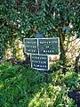 Canal milepost near Park Heath.jpg 734 × 979; 506 KB
-
 Canal Mooring - geograph.org.uk - 425375.jpg 424 × 640; 76 KB
-
 Canal Near Beeston.jpg 1,984 × 1,488; 631 KB
-

-
 Canal side housing - geograph.org.uk - 398739.jpg 600 × 450; 240 KB
-
 Canal south-east of Barbridge in Cheshire - geograph.org.uk - 5518232.jpg 1,280 × 729; 784 KB
-
 Canal south-east of Barbridge in Cheshire - geograph.org.uk - 5518235.jpg 1,280 × 960; 977 KB
-

-
 Canal towpath by High Bridge - geograph.org.uk - 240302.jpg 640 × 480; 140 KB
-
 Canal Tunnel, Shelmore Wood.jpg 640 × 426; 167 KB
-
 Canal View - geograph.org.uk - 648312.jpg 640 × 480; 63 KB
-
 Canal, pub and mill at Audlem, Cheshire - geograph.org.uk - 1330902.jpg 640 × 470; 145 KB
-

-
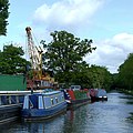
 Canalside Crane at Norbury - geograph.org.uk - 965198.jpg 480 × 640; 113 KB
-

-
 Canalside Property - geograph.org.uk - 444830.jpg 600 × 450; 255 KB
-
 Canalside Warehouse - geograph.org.uk - 444832.jpg 600 × 401; 185 KB
-
 Canalware sales boat at Audlem, Cheshire - geograph.org.uk - 1601587.jpg 640 × 472; 121 KB
-
-
 Cattle pasture near Bettonwood Farm - geograph.org.uk - 257931.jpg 640 × 480; 140 KB
-
 Cheshire West and Chester, UK - panoramio - IIya Kuzhekin (1).jpg 4,000 × 2,250; 2.73 MB
-
 Christleton - Shropshire Union Canal - geograph.org.uk - 976307.jpg 480 × 640; 333 KB
-

-

-

-

-

-

-

-

-

-

-

-

-

-

-

-
 Course of former canal - geograph.org.uk - 1275077.jpg 640 × 457; 190 KB
-
 Cows by the Shropshire Union Canal - geograph.org.uk - 257627.jpg 640 × 471; 129 KB
-
 Crisp, Cold, Christleton Canal - geograph.org.uk - 694382.jpg 640 × 480; 80 KB
-

-

-
 DraytonViaduct.JPG 1,600 × 1,200; 930 KB
-
 Ducks beside Shropshire Union Canal - geograph.org.uk - 186795.jpg 640 × 493; 108 KB
-
-
 Edleston - Shropshire Union Canal.jpg 640 × 451; 172 KB
-

-
 Embankment on the Shropshire Union Canal - geograph.org.uk - 381651.jpg 640 × 374; 117 KB
-
 End of the season - geograph.org.uk - 269891.jpg 640 × 412; 50 KB
-

-
 Entrance to new marina - Overwater - near Audlem - geograph.org.uk - 1749153.jpg 3,296 × 2,472; 1.84 MB
-

-

-
 Fishing on the Union - geograph.org.uk - 1216005.jpg 640 × 480; 90 KB
-

-
 Footpath to Brewood - geograph.org.uk - 737603.jpg 640 × 480; 57 KB
-
 Foxglove on the Shropshire Union Canal.jpg 4,032 × 3,024; 4.89 MB
-
 From the bridge at Croughton - geograph.org.uk - 1580904.jpg 640 × 428; 89 KB
-

-

-

-

-

-

-

-

-

-

-
 Gnosall Heath - geograph.org.uk - 182424.jpg 640 × 480; 122 KB
-
 Golden Nook - geograph.org.uk - 190445.jpg 640 × 480; 133 KB
-
 Golden Nook - geograph.org.uk - 220166.jpg 640 × 480; 91 KB
-
 Goldstone Wharf, Market Drayton - geograph.org.uk - 280073.jpg 640 × 424; 85 KB
-

-
 Golf Course - geograph.org.uk - 34706.jpg 640 × 480; 146 KB
-
 Good Friday on the Shropshire Union Canal - geograph.org.uk - 398761.jpg 600 × 450; 293 KB
-
 Grand Union Canal at Upper Cowley - geograph.org.uk - 170548.jpg 480 × 640; 248 KB
-

-
-

-
 Here's a good catch ^ - geograph.org.uk - 240539.jpg 640 × 480; 71 KB
-
 High Onn Wharf - geograph.org.uk - 444826.jpg 600 × 450; 205 KB
-
 High Onn Wharf - geograph.org.uk - 452984.jpg 640 × 480; 102 KB
-

-

-
 Hurleston Flight - geograph.org.uk - 129588.jpg 640 × 429; 88 KB
-
 Keepers Cottage, Tarvin Lock - geograph.org.uk - 304957.jpg 640 × 480; 77 KB
-
 KnollsBridge.jpg 6,720 × 4,480; 20.06 MB
-

-
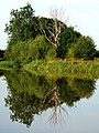 Lightning Reflection - geograph.org.uk - 1451517.jpg 480 × 640; 127 KB
-
 Lock Gates at Bridge 92, Shropshire Union Canal, Nantwich.jpg 4,000 × 2,664; 3.11 MB
-
 Lock Gates by Bridge 92, Shropshire Union Canal, Nantwich.jpg 4,000 × 2,664; 3.33 MB
-

-
-
 Looking up to the top lock, Tyrley - geograph.org.uk - 828014.jpg 480 × 640; 103 KB
-

-
 Market Drayton, Shropshire Union Canal July 1981 Slides297 (10430547955).jpg 1,684 × 1,124; 295 KB
-
 Middlewich Branch Canal near Church Minshull (geograph 5600583).jpg 1,280 × 851; 586 KB
-
 Milepost 0.5 miles north of Norbury Junction.jpg 800 × 658; 279 KB
-
 Milepost 0.5 miles south of Norbury Junction.jpg 800 × 780; 256 KB
-
 Milepost 1.5 miles north of Norbury Junction.jpg 800 × 667; 259 KB
-
 Milepost 1.5 miles south of Norbury Junction.jpg 800 × 743; 278 KB
-
 Milepost 3.5 miles north of Norbury Junction.jpg 800 × 685; 187 KB
-
 Milepost 3.5 miles south of Norbury Junction.jpg 800 × 749; 326 KB
-
 Milepost at NGR SJ 866 118.jpg 800 × 785; 317 KB
-
 Milepost at NGR SJ 874 104.jpg 800 × 772; 295 KB
-
 Milepost at NGR SJ 891 060.jpg 800 × 665; 262 KB
-
 Milepost at southeast of bridge No. 59.jpg 1,157 × 1,750; 337 KB
-
 Milepost near Fox Bridge.jpg 979 × 734; 510 KB
-
 Milepost north of Brewood Bridge.jpg 800 × 745; 224 KB
-
 Milepost south of bridge No. 61, Shropshire Union Canal.jpg 857 × 1,142; 614 KB
-
 Milepost south of Norbury Junction.jpg 796 × 800; 295 KB
-
 Milepost, Shropshire Union Canal.jpg 640 × 480; 146 KB
-

-
 Moored working boat near Acton in Cheshire - geograph.org.uk - 5518526.jpg 1,280 × 960; 1.14 MB
-
 Nantwich embankment.jpg 640 × 509; 102 KB
-
 Nantwich Marina - geograph.org.uk - 701897.jpg 640 × 403; 125 KB
-
 Nantwich Road Aqueduct, Middlewich.jpg 800 × 603; 383 KB
-
 Narrow boat, Shropshire Union canal - geograph.org.uk - 1099565.jpg 640 × 428; 68 KB
-

-
 Narrowboat 'Gailey Ranger' Shropshire Union Canal 24.7.1981 (10430682793).jpg 2,345 × 1,562; 534 KB
-

-

-
 Narrowboat on the Canal - geograph.org.uk - 182957.jpg 640 × 480; 71 KB
-
 Narrowboat on the Shropshire Union Canal, Cheshire - DSC06322.JPG 3,648 × 2,736; 3.63 MB
-
 Narrowboat on the Shropshire Union Canal, Cheshire - DSC06323.JPG 3,648 × 2,736; 3.48 MB
-

-
 Narrowboat refuelling near Acton, Cheshire - geograph.org.uk - 5519107.jpg 1,280 × 906; 956 KB
-
 Narrowboat, Shropshire Union Canal, Cheshire - DSC06341.JPG 3,648 × 2,736; 3.57 MB
-

-

-
 Narrowboats moored for the night, Shebdon - geograph.org.uk - 1803987.jpg 3,296 × 2,472; 1.84 MB
-
 Narrowboats north-west of Nantwich in Cheshire - geograph.org.uk - 5519116.jpg 1,280 × 836; 995 KB
-

-
 Narrowboats. - geograph.org.uk - 422039.jpg 640 × 480; 84 KB
-
 NCR 5 - 56 near Stoak - geograph.org.uk - 1442850.jpg 640 × 426; 288 KB
-
 NCR 5 alongside the sewage works - geograph.org.uk - 1442854.jpg 640 × 426; 405 KB
-


mobile_homes_-_geograph.org.uk_-_737512.jpg)
_-_20230826091831.jpeg)
_-_20230826091901.jpeg)


.jpg)

_At_Sj_835_168_-_20230825123323.jpeg)
_At_Sj_835_168_-_20230825123430.jpeg)
_At_Sj_835_168_-_20230825124103.jpeg)
_At_Sj_835_168_-_20230825124211.jpeg)
_At_Sj_842_161_-_20230825124405.jpeg)
_At_Sj_842_161_-_20230825124533.jpeg)
_At_Sj_831_177_-_20230825120326.jpeg)
_At_Sj_831_177_-_20230825120356.jpeg)
_At_Sj_831_177_-_20230825120515.jpeg)
_At_Sj_831_173_-_20230825120622.jpeg)
_At_Sj_831_173_-_20230825120759.jpeg)
_At_Sj_832_171_-_20230825121407.jpeg)
_At_Sj_832_171_-_20230825121456.jpeg)
_At_Sj_831_181_-_20230825115859.jpeg)
_At_Sj_831_181_-_20230825115953.jpeg)


_At_Sj_827_192_-_20230825113857.jpeg)
_At_Sj_827_192_-_20230825114018.jpeg)
_At_Sj_829_189_-_20230825114307.jpeg)
_At_Sj_829_189_-_20230825114401.jpeg)
_At_Sj_819_203_-_20230825105607.jpeg)
_At_Sj_819_203_-_20230825105714.jpeg)
_At_Sj_821_201_-_20230825112302.jpeg)
_At_Sj_821_201_-_20230825112437.jpeg)
_At_Sj_815_206_-_20230825104822.jpeg)
_At_Sj_815_206_-_20230825104947.jpeg)


.jpg)
.jpg)


.jpg)
.jpg)


