Category:Sillery (Quebec)
Français : Quartier Sillery, situé dans l’arrondissement Sainte-Foy–Sillery–Cap-Rouge à Québec

neighborhood in the borough of Sainte-Foy–Sillery–Cap-Rouge, in Quebec City  Commercial Maguire Street (avenue Maguire) .jpg)  Coat of arms  Sillery in relation to Québec City's boroughs and other districts | |||||
| Upload media | |||||
| Instance of |
| ||||
|---|---|---|---|---|---|
| Part of | |||||
| Named after | |||||
| Location | Sainte-Foy–Sillery–Cap-Rouge, Quebec City, Quebec, Capitale-Nationale, Quebec, Canada | ||||
| Located in or next to body of water | |||||
| Population |
| ||||
| Area |
| ||||
| Elevation above sea level |
| ||||
| Different from | |||||
| official website | |||||
 | |||||
Subcategories
This category has the following 30 subcategories, out of 30 total.
+
1
- 1678, chemin Saint-Louis (2 F)
2
- 2208-2212, chemin du Foulon (22 F)
A
- Anse de Sillery (9 F)
- Anse Saint-Michel (6 F)
B
- Villa Bagatelle (15 F)
- Villa Beauvoir (61 F)
C
- Domaine Cataraqui (37 F)
G
J
M
- Maison William Lee (3 F)
Q
S
- Église Saint-Michel de Sillery (25 F)
- St-Patrick Cemetery (13 F)
- John Sharples Jr. (2 F)
V
- Villa Benmore (22 F)
- Villa Clermont (10 F)
- Villa Sous-les-Bois (8 F)
Y
- Yacht Club de Québec (16 F)
Media in category "Sillery (Quebec)"
The following 22 files are in this category, out of 22 total.
-
 Blason Sillery.svg 600 × 660; 7 KB
-
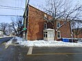
 1401, avenue du Chanoine-Morel.jpg 4,000 × 3,000; 10.57 MB
-
 1700, chemin Saint-Louis.jpg 3,264 × 2,448; 7.82 MB
-
 1737, chemin Saint-Louis.jpg 3,264 × 2,448; 8.19 MB
-
 Bibliotheque Charles-H.-Blais.jpg 5,152 × 3,864; 3.45 MB
-
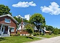
 Couleurs d'automne - panoramio (2).jpg 2,816 × 1,584; 3.74 MB
-
 In old Sillery, Quebec (I0016646).jpg 4,097 × 3,330; 4.34 MB
-
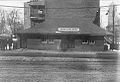 La Jonction de Sillery.jpg 960 × 657; 122 KB
-
 La Maison Michel Sarrazin.jpg 3,183 × 2,112; 4.33 MB
-

-
-
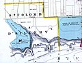
 Localisation de Sillery dans Québec.svg 512 × 455; 11 KB
-
 Maison Sillery.jpg 3,136 × 2,352; 4.79 MB
-
 Maison, 2206, chemin du Foulon, Québec façade 11-d.na.civile-83-2136.jpg 1,500 × 967; 1.16 MB
-
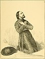
 Pontville; la naissance d'une ville (1914) (14770758171).jpg 2,632 × 3,376; 2.15 MB
-
 Quebec, pres du Cap Diamant.jpg 1,024 × 827; 195 KB
-
 Québec City – Boulevard Champlain - Le Fleuve Saint-Lorent - panoramio (1).jpg 4,000 × 3,000; 2.34 MB
-
 Rue du Colonel-Mathieu.jpg 3,744 × 2,696; 3.29 MB
-
-
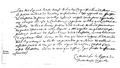 SOJ-fax-Du Quen.png 1,438 × 819; 203 KB
-
 WPQc-170 Parc du Bois-de-Coulonge - Église St-Michel de Sillery.JPG 5,010 × 3,340; 4.62 MB
-
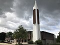 Église Saint-Yves de Sillery.jpg 4,032 × 3,024; 3.05 MB


.jpg)
.jpg)


_(14740292826).jpg)


_(14770758171).jpg)


.jpg)


