Category:Simssee
| Object location | | View all coordinates using: OpenStreetMap |
|---|
This is the category of the protected area listed at WDPA under the ID 395539
|
This is the category of the protected area listed at WDPA under the ID 555522148
|
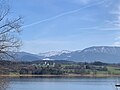
Deutsch: Landschaftsschutzgebiet Schutz des Simssees und seiner Umgebung (LSG-00111.01) in Oberbayern, Landkreis Rosenheim. Die Wasserfläche sowie das Südufer des Sees sind als FFH-Gebiet Simsseegebiet (8139-371) ausgewiesen.
lake in Rosenheim district, Bavaria, Germany .jpg) | |||||
| Upload media | |||||
| Instance of | |||||
|---|---|---|---|---|---|
| Located in protected area | |||||
| Location | Rosenheim, Upper Bavaria, Bavaria, Germany | ||||
| Width |
| ||||
| Length |
| ||||
| Area |
| ||||
| Elevation above sea level |
| ||||
| Inflows |
| ||||
| Outflows | |||||
| Drainage basin | |||||
| Basin country | |||||
 | |||||
Media in category "Simssee"
The following 47 files are in this category, out of 47 total.
-
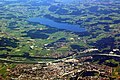
 Aerial image of Lake Simssee (view from the southwest).jpg 5,300 × 3,600; 8.77 MB
-
 Boat on Simssee.jpg 800 × 1,066; 201 KB
-
 CRW 8052.jpg 1,024 × 681; 458 KB
-
 CRW 8056.jpg 1,024 × 681; 281 KB
-
 CRW 8095 lzn.jpg 1,024 × 681; 184 KB
-
 CRW 8102.jpg 1,024 × 681; 337 KB
-
 CRW 8116.jpg 1,024 × 681; 203 KB
-
 CRW 8136.jpg 1,024 × 681; 200 KB
-
 Hannover Rom -Luftaufnahmen- 2014 by-RaBoe 056.jpg 2,500 × 1,661; 1,006 KB
-
 Joseph Wenglein Blick auf den Simssee im Frühling.jpg 4,070 × 1,863; 1.26 MB
-
 Lago Simsee - panoramio.jpg 1,772 × 1,181; 2.1 MB
-
 Location Simssee.PNG 717 × 442; 51 KB
-
 Michael Licklederer Blick über den Simssee c1935.jpg 2,560 × 2,411; 1.13 MB
-
 Michael Licklederer Kampenwand mit Simssee 1932.jpg 2,276 × 2,560; 990 KB
-
 Michael Licklederer Simsee mit Heuberg 1923.jpg 2,002 × 2,560; 1.11 MB
-
 Michael Licklederer Simssee-Abend 1943.jpg 2,560 × 1,920; 1.13 MB
-
 Michael Licklederer Stürmische Segelpartie am Simssee 1919.jpg 2,560 × 1,687; 1.04 MB
-
 Neukirchen am Simssee mit Kampenwand.jpg 800 × 600; 125 KB
-
 Paul Roloff Blick über den Simssee 1910.jpg 5,000 × 4,017; 27.88 MB
-
 Riedering, Germany - panoramio.jpg 2,560 × 1,920; 1.49 MB
-
 Rosenheim, X, aufgehellt.jpeg 3,000 × 2,000; 1.7 MB
-
 Rosenheim.JPG 3,000 × 2,000; 1,023 KB
-
 Sims Simssee Suedufer Ecking Riedering-1.jpg 5,472 × 3,648; 3.18 MB
-
 Simssee 1830 Karte im Stromatlas.jpg 1,362 × 1,193; 362 KB
-
 Simssee 4.jpg 4,000 × 3,000; 3.71 MB
-
 Simssee 6.jpg 4,000 × 3,000; 4.78 MB
-
 Simssee bei Baierbach – Blick auf Neukirchen.jpg 4,032 × 3,024; 1.66 MB
-
 Simssee Chiemsee.JPG 1,944 × 1,296; 362 KB
-
 Simssee Nordufer-1.jpg 5,470 × 3,205; 1.75 MB
-
 Simssee Sonnenuntergang.jpg 2,736 × 1,824; 1.55 MB
-
 Simssee Suedufer Beuerberg Riedering-1.jpg 5,335 × 3,225; 2.28 MB
-
 Simssee Suedufer Beuerberg Riedering-2.jpg 5,472 × 3,648; 3.56 MB
-
 Simssee Suedufer Beuerberg Riedering-3.jpg 5,355 × 3,485; 2.87 MB
-
 Simssee Suedufer Ecking Riedering-1.jpg 5,380 × 2,765; 1.87 MB
-
 Simssee Suedufer Ecking Riedering-2.jpg 5,472 × 3,648; 2.63 MB
-
 Simssee Suedufer Ecking Riedering-3.jpg 5,465 × 2,915; 1.68 MB
-
 Simssee Suedufer Ecking Riedering-4.jpg 5,472 × 3,648; 2.07 MB
-
 Simssee Suedufer Pietzenkirchen Riedering-1.jpg 5,472 × 3,648; 2.96 MB
-
 Simssee Suedufer Pietzing Riedering-1.jpg 5,472 × 3,648; 3.29 MB
-
 Simssee Suedufer Pietzing Riedering-2.jpg 5,472 × 3,648; 3.69 MB
-
 Simssee Suedufer Pietzing Riedering-3.jpg 5,465 × 2,970; 1.97 MB
-
 Simssee Suedufer Wendelstein Beuerberg Riedering-1.jpg 5,465 × 3,190; 1.93 MB
-
 Simssee von Pietzenkirchen.jpg 4,032 × 2,268; 4.2 MB
-
 Simssee-3.jpg 2,592 × 1,944; 935 KB
-
 Simssee.JPG 2,272 × 1,704; 967 KB
-
 Simssee.jpg 1,600 × 891; 236 KB
-
 Sunset at Simssee.jpg 4,032 × 3,024; 4.54 MB


