Category:Sint-Lambertuskerk (Veghel)
| Object location | | View all coordinates using: OpenStreetMap |
|---|
church building in Veghel, Netherlands  .jpg)  | |||||
| Upload media | |||||
| Instance of | |||||
|---|---|---|---|---|---|
| Named after | |||||
| Dedicated to | |||||
| Location | Veghel, Meierijstad, North Brabant, Netherlands | ||||
| Street address |
| ||||
| Located on street | |||||
| Architectural style | |||||
| Architect | |||||
| Heritage designation |
| ||||
| Inception |
| ||||
| Religion or worldview | |||||
| Maximum capacity |
| ||||
 | |||||
Nederlands: Kerk, Deken van Miertstraat 2, 5460 AA te Veghel, met naastgelegen doopkapel. Na onttrekking aan de eredienst werd de kapel een moskee, maar ook deze functie verviel. De leegstaande kapel brandde tot de grond toe af tijdens de Nieuwjaarsnacht van 2023.
|
This is a category about rijksmonument number 37037
|
Kapel, Mr. van Coothstraat 1, 5461 AC te Veghel
|
This is a category about rijksmonument number 521265
|
Kerkhof, 5460 AA te Veghel
|
This is a category about rijksmonumentcomplex number 521254
|
| Address |
|
Subcategories
This category has the following 5 subcategories, out of 5 total.
C
- Calvary (Veghel) (4 F)
- Congregatiekapel (Veghel) (7 F)
K
Media in category "Sint-Lambertuskerk (Veghel)"
The following 97 files are in this category, out of 97 total.
-

-
 Exterieur - Veghel - 20239980 - RCE.jpg 1,200 × 953; 209 KB
-
 Exterieur - Veghel - 20239982 - RCE.jpg 953 × 1,200; 182 KB
-

-

-

-

-

-

-

-

-
 Exterieur koor - Veghel - 20239983 - RCE.jpg 1,200 × 957; 216 KB
-
 Exterieur overzicht - Veghel - 20239976 - RCE.jpg 957 × 1,200; 210 KB
-
 Exterieur overzicht - Veghel - 20239981 - RCE.jpg 950 × 1,200; 199 KB
-
 Exterieur OVERZICHT - Veghel - 20286165 - RCE.jpg 1,195 × 1,200; 287 KB
-

-

-

-
 Exterieur SCHIP, GOOTLIJN, DETAIL (TIJDENS RESTAURATIE) - Veghel - 20285795 - RCE.jpg 1,193 × 1,200; 315 KB
-
 Exterieur SCHIP, ZWENKING DAKLIJN, (TIJDENS RESTAURATIE) - Veghel - 20285794 - RCE.jpg 1,197 × 1,200; 304 KB
-
 Exterieur TOREN, BALDAKIJN, (TIJDENS RESTAURATIE) - Veghel - 20285796 - RCE.jpg 1,200 × 1,193; 410 KB
-
 Exterieur TOREN, BALUSTRADE, DETAIL, (TIJDENS RESTAURATIE) - Veghel - 20285793 - RCE.jpg 1,195 × 1,200; 352 KB
-

-

-

-
-

-

-

-

-
-
-
-

-

-

-

-

-

-
-

-
-

-

-

-
-
-

-

-
 Exterieur TOREN, GALMBORD, DETAIL (TIJDENS RESTAURATIE) - Veghel - 20285802 - RCE.jpg 1,193 × 1,200; 392 KB
-

-
 Exterieur TOREN, SPITSVOET, DETAIL (TIJDENS RESTAURATIE) - Veghel - 20285803 - RCE.jpg 1,186 × 1,200; 334 KB
-

-
 Exterieur TOREN, STEUNBEER, DETAIL (TIJDENS RESTAURATIE) - Veghel - 20285800 - RCE.jpg 1,188 × 1,200; 336 KB
-
 Exterieur TOREN, STEUNBEER, DETAIL (TIJDENS RESTAURATIE) - Veghel - 20285801 - RCE.jpg 1,190 × 1,200; 361 KB
-
 Exterieur TOREN, STEUNBEER, DETAIL, (TIJDENS RESTAURATIE) - Veghel - 20285799 - RCE.jpg 1,197 × 1,200; 382 KB
-

-

-
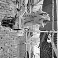 Exterieur TOREN, UITNEMEN SPUWER, (TIJDENS RESTAURATIE) - Veghel - 20285792 - RCE.jpg 1,197 × 1,200; 378 KB
-

-
 Interieur - Veghel - 20239987 - RCE.jpg 954 × 1,200; 248 KB
-
 Interieur - Veghel - 20239988 - RCE.jpg 948 × 1,200; 269 KB
-
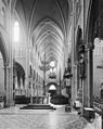
 Interieur naar het koor - Veghel - 20239977 - RCE.jpg 953 × 1,200; 284 KB
-
 Interieur naar het koor - Veghel - 20239985 - RCE.jpg 946 × 1,200; 287 KB
-
 Interieur naar het koor - Veghel - 20239986 - RCE.jpg 944 × 1,200; 283 KB
-
 Interieur naar het orgel - Veghel - 20239984 - RCE.jpg 954 × 1,200; 269 KB
-

-

-
 Markt en Sint-Lambertuskerk, Veghel.jpg 3,000 × 4,000; 2.5 MB
-
 Meierijstad-Veghel, de Sint-Lambertuskerk RM37037 IMG 4578 2023-04-17 15.02.jpg 3,048 × 4,944; 7.73 MB
-
-
 Overzicht oostgevels met kerkhof - Veghel - 20347805 - RCE.jpg 1,185 × 1,200; 264 KB
-
 Overzicht voorgevel en gedeelte rechter zijgevel - Veghel - 20347814 - RCE.jpg 1,192 × 1,200; 334 KB
-
 RK Kerkhof Veghel 521258.JPG 3,072 × 4,608; 3.37 MB
-
 RK Kerkhof Veghel 525750.JPG 3,072 × 4,608; 3.36 MB
-
 RK Kerkhof Veghel 525754.JPG 3,072 × 4,608; 3.26 MB
-
 Rooms-Katholieke Sint Lambertuskerk, oost-zijde - Veghel - 20239978 - RCE.jpg 1,200 × 952; 167 KB
-
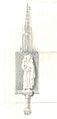
 Sint Lambertus.jpg 960 × 720; 489 KB
-
 T.T Grafmonument JCM Rath Veghel 521257 (2).JPG 3,072 × 4,608; 3.41 MB
-
 T.T Grafmonument LCHM v Sasse v Ysselt Veghel 521256 (1).JPG 3,072 × 4,608; 3.37 MB
-
 T.T RK Kerk st Lambertus Veghel.JPG 3,072 × 2,048; 1.31 MB
-
 T.T RK Kerk Veghel.JPG 3,072 × 4,608; 3.11 MB
-
 T.T vm Kapel te Veghel.JPG 3,072 × 4,608; 3.31 MB
-
 Toren - Veghel - 20239975 - RCE.jpg 947 × 1,200; 199 KB
-

-
 Veghel (N-Br, NL), church, front view.JPG 2,304 × 3,072; 2.78 MB
-
 Veghel (N-Br, Nl), statues frontside church.JPG 2,304 × 3,072; 3.15 MB
-
 Veghel Aa Lambertuskerk.jpg 4,256 × 2,848; 3.22 MB
-
 Veghel Markt Anamorphic.jpg 4,032 × 1,687; 4.7 MB
-
 Veghel Markt oude situatie ca. 1910.jpg 472 × 343; 118 KB
-
 Veghel Markt oude situatie.jpg 3,302 × 2,374; 1.19 MB
-
 Veghel Rijksmonument 37037 St.Lambertuskerk.JPG 3,072 × 2,304; 2.87 MB
-
 Veghel St. Lambertuskerk.jpg 2,448 × 3,264; 2.46 MB
-
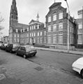
 Veghel-Klooster-DekenvanMiertstraat.jpg 1,536 × 1,872; 459 KB
-
 Veghel-Markt (2).jpg 4,256 × 2,848; 2.67 MB
-
 Veghellambertuskerk.jpg 500 × 375; 106 KB
-
 West-zijde toren - Veghel - 20239979 - RCE.jpg 2,418 × 3,091; 1.92 MB


_-_Veghel_-_20285795_-_RCE.jpg)
_-_Veghel_-_20285794_-_RCE.jpg)
_-_Veghel_-_20285796_-_RCE.jpg)
_-_Veghel_-_20285793_-_RCE.jpg)


_-_Veghel_-_20285802_-_RCE.jpg)
_-_Veghel_-_20285790_-_RCE.jpg)
_-_Veghel_-_20285803_-_RCE.jpg)
_-_Veghel_-_20285797_-_RCE.jpg)
_-_Veghel_-_20285800_-_RCE.jpg)
_-_Veghel_-_20285801_-_RCE.jpg)
_-_Veghel_-_20285799_-_RCE.jpg)
_-_Veghel_-_20285798_-_RCE.jpg)
_-_Veghel_-_20285804_-_RCE.jpg)
_-_Veghel_-_20285792_-_RCE.jpg)
_-_Veghel_-_20285791_-_RCE.jpg)


.JPG)
.JPG)


,_church,_front_view.JPG)
,_statues_frontside_church.JPG)


