Category:Sint Jan de Doper, Arnhem
| Object location | | View all coordinates using: OpenStreetMap |
|---|
church building in Arnhem, Netherlands  | |||||
| Upload media | |||||
| Instance of | |||||
|---|---|---|---|---|---|
| Part of | |||||
| Location | Arnhem, Gelderland, Netherlands | ||||
| Street address |
| ||||
| Located on street |
| ||||
| Architect | |||||
| Heritage designation |
| ||||
| Inception |
| ||||
| Religion or worldview | |||||
 | |||||
|
This is a category about rijksmonument number 516735
|
| Address |
|
Subcategories
This category has the following 2 subcategories, out of 2 total.
K
Media in category "Sint Jan de Doper, Arnhem"
The following 35 files are in this category, out of 35 total.
-
 Aquarel van kerk, 1742 - Arnhem - 20407469 - RCE.jpg 1,200 × 885; 270 KB
-
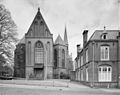 Exterieur - Arnhem - 20308216 - RCE.jpg 1,200 × 951; 261 KB
-

-

-
 INT. CIBORIE - Arnhem - 20308236 - RCE.jpg 1,195 × 1,200; 179 KB
-
 INT. CIBORIE - Arnhem - 20308237 - RCE.jpg 1,195 × 1,200; 179 KB
-
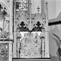
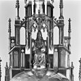
 INT. HOOGALTAAR - Arnhem - 20308225 - RCE.jpg 1,197 × 1,200; 363 KB
-
 INT. HOOGALTAAR, ACHTER GLASSCHILDERING OP TOMBE - Arnhem - 20308234 - RCE.jpg 1,195 × 1,200; 311 KB
-
 INT. HOOGALTAAR, ACHTER GLASSCHILDERING OP TOMBE - Arnhem - 20308235 - RCE.jpg 1,192 × 1,200; 323 KB
-
 INT. HOOGALTAAR, DETAIL - Arnhem - 20308222 - RCE.jpg 1,200 × 1,200; 312 KB
-
 INT. HOOGALTAAR, DETAIL - Arnhem - 20308223 - RCE.jpg 1,197 × 1,200; 312 KB
-
 INT. HOOGALTAAR, DETAIL - Arnhem - 20308224 - RCE.jpg 1,197 × 1,200; 295 KB
-
 INT. HOOGALTAAR, DETAIL TOMBE - Arnhem - 20308226 - RCE.jpg 1,200 × 1,197; 262 KB
-
 INT. KOOR, MARIA ALTAAR EN HOOGALTAAR - Arnhem - 20308242 - RCE.jpg 954 × 1,200; 253 KB
-
 INT. LINKER ZIJBEUK - Arnhem - 20308220 - RCE.jpg 954 × 1,200; 224 KB
-
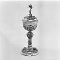
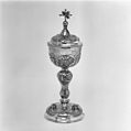
 INT. MONSTRANS - Arnhem - 20308239 - RCE.jpg 1,200 × 1,200; 183 KB
-
 INT. MONSTRANS - Arnhem - 20308240 - RCE.jpg 1,200 × 1,200; 278 KB
-
 INT. MONSTRANS - Arnhem - 20308241 - RCE.jpg 1,195 × 1,200; 277 KB
-
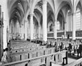 INT. NAAR HET KOOR - Arnhem - 20308217 - RCE.jpg 1,200 × 956; 251 KB
-
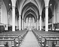 INT. NAAR PRIESTERKOOR - Arnhem - 20308218 - RCE.jpg 1,200 × 958; 223 KB
-
 INT. NAAR PRIESTERKOOR - Arnhem - 20308219 - RCE.jpg 1,200 × 952; 226 KB
-
 INT. PANEELBESCHILDERING OP KOPER UIT HOOGALTAAR - Arnhem - 20308228 - RCE.jpg 1,197 × 1,200; 355 KB
-
 INT. PANEELBESCHILDERING OP KOPER UIT HOOGALTAAR - Arnhem - 20308229 - RCE.jpg 1,200 × 1,200; 362 KB
-
 INT. PANEELBESCHILDERING OP KOPER UIT JOZEF ALTAAR - Arnhem - 20308231 - RCE.jpg 1,200 × 1,195; 378 KB
-
 INT. PANEELBESCHILDERING OP KOPER UIT JOZEF ALTAAR - Arnhem - 20308233 - RCE.jpg 1,190 × 1,200; 371 KB
-
 INT. PANEELBESCHILDERING OP KOPER UIT MARIA ALTAAR - Arnhem - 20308230 - RCE.jpg 1,193 × 1,200; 348 KB
-
 INT. PANEELBESCHILDERING OP KOPER UIT MARIA ALTAAR - Arnhem - 20308232 - RCE.jpg 1,198 × 1,200; 355 KB
-
 INT. SACRAMENTSVAAN, ATELIER MENGELBERG - Arnhem - 20308238 - RCE.jpg 1,195 × 1,200; 302 KB
-
 INT. SINT JOZEFALTAAR - Arnhem - 20308221 - RCE.jpg 946 × 1,200; 230 KB
-
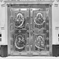 INT. TABERNAKELDEUREN HOOGALTAAR - Arnhem - 20308227 - RCE.jpg 1,195 × 1,200; 322 KB
-
 Jans toren arnhem.jpg 230 × 307; 14 KB
-
 Janskerk1742.jpg 500 × 363; 31 KB
-
 Noord-zijde kerk - Arnhem - 20024916 - RCE.jpg 1,200 × 970; 267 KB
-

-
 Voorzijde Toren - Arnhem - 20024915 - RCE.jpg 1,200 × 1,185; 325 KB


