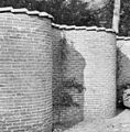
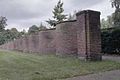
Category:Slingermuur, Sparrendaal (Driebergen-Rijsenburg)
| Object location | | View all coordinates using: OpenStreetMap |
|---|
 | |||||
| Upload media | |||||
| Instance of | |||||
|---|---|---|---|---|---|
| Part of | |||||
| Location | Driebergen-Rijsenburg, Utrecht, Netherlands | ||||
| Street address |
| ||||
| Heritage designation |
| ||||
 | |||||
|
This is a category about rijksmonument number 519734
|
| Address |
|
Media in category "Slingermuur, Sparrendaal (Driebergen-Rijsenburg)"
The following 18 files are in this category, out of 18 total.
-
 Driebergen-Rijsenburg - Sparrendaal Slingermuur RM519734.JPG 4,608 × 3,456; 3.79 MB
-
 Exterieur DETAIL SLANGENMUUR - Driebergen-Rijsenburg - 20289853 - RCE.jpg 1,181 × 1,200; 401 KB
-
 Exterieur OVERZICHT SLANGENMUUR - Driebergen-Rijsenburg - 20289849 - RCE.jpg 1,183 × 1,200; 475 KB
-
 Exterieur OVERZICHT SLANGENMUUR - Driebergen-Rijsenburg - 20289850 - RCE.jpg 1,197 × 1,200; 484 KB
-
 Exterieur OVERZICHT SLANGENMUUR - Driebergen-Rijsenburg - 20289852 - RCE.jpg 1,193 × 1,200; 453 KB
-
 Exterieur SLANGENMUUR - Driebergen-Rijsenburg - 20289851 - RCE.jpg 1,197 × 1,200; 440 KB
-
 Exterieur TOEGANGSHEK - Driebergen-Rijsenburg - 20289848 - RCE.jpg 1,200 × 1,199; 384 KB
-
 Overzicht fruitmuur - Driebergen-Rijsenburg - 20311967 - RCE.jpg 1,192 × 1,200; 475 KB
-

-

-
 SLANGEMUUR - Driebergen-Rijsenburg - 20354668 - RCE.jpg 1,200 × 795; 226 KB
-
 SLANGEMUUR - Driebergen-Rijsenburg - 20354670 - RCE.jpg 810 × 1,200; 224 KB
-
 SLANGEMUUR - Driebergen-Rijsenburg - 20354674 - RCE.jpg 1,200 × 797; 222 KB
-
 SLANGEMUUR - Driebergen-Rijsenburg - 20354685 - RCE.jpg 1,200 × 796; 198 KB
-
 SLANGEMUUR - Driebergen-Rijsenburg - 20354686 - RCE.jpg 1,200 × 795; 247 KB
-
 SLANGEMUUR BOVENZIJDE - Driebergen-Rijsenburg - 20354687 - RCE.jpg 795 × 1,200; 251 KB
-
 Sparrendaal (Driebergen-Rijsenburg). Slingermuur (1).jpg 4,320 × 2,432; 4.8 MB
-
 Sparrendaal (Driebergen-Rijsenburg). Slingermuur (2).jpg 4,320 × 2,432; 4.65 MB


._Slingermuur_(1).jpg)
._Slingermuur_(2).jpg)