Category:Smoky Cape Lighthouse
| Object location | | View all coordinates using: OpenStreetMap |
|---|
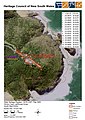
English: Smoky Cape Lighthouse is a heritage-listed lighthouse at Smoky Cape, Arakoon, South-West Rocks, Kempsey Shire, New South Wales, Australia.
lighthouse in New South Wales, Australia  | |||||
| Upload media | |||||
| Instance of | |||||
|---|---|---|---|---|---|
| Location |
| ||||
| Street address |
| ||||
| Architect | |||||
| Heritage designation |
| ||||
| Source of energy | |||||
| Area |
| ||||
 | |||||
Media in category "Smoky Cape Lighthouse"
The following 14 files are in this category, out of 14 total.
-
 1007 - Smoky Cape Lighthouse Group - SHR Plan No 2953 (5045071b100).jpg 707 × 1,000; 287 KB
-
 Kangaroo at Smoky Cape Lighthouse - panoramio.jpg 1,944 × 2,592; 794 KB
-
 Smokey Cape Light 1917.jpg 314 × 425; 37 KB
-
 Smoky Cape historic.jpg 600 × 369; 37 KB
-
 Smoky Cape Light and Quarters, 1902.jpg 1,400 × 1,278; 430 KB
-
 Smoky Cape Light, lighthouse plans, 1888.jpg 2,362 × 1,496; 262 KB
-
 Smoky Cape Light, plan of keepers' quarters, 1888.jpg 2,347 × 1,572; 316 KB
-
 Smoky Cape Light, plan of quarters drainage, 1888.jpg 1,566 × 2,362; 244 KB
-
 Smoky Cape Light, plan of site, 1888.jpg 2,362 × 1,344; 208 KB
-
 Smoky Cape Lighthouse (30273584064).jpg 682 × 1,024; 527 KB
-
 Smoky Cape Lighthouse (30606869590).jpg 1,280 × 853; 872 KB
-
 Smoky Cape Lighthouse.jpg 4,032 × 3,024; 4.24 MB
-
 Smoky Cape.jpg 3,556 × 2,550; 2.36 MB
-
 SmokyCapeLighthouse.JPG 1,430 × 2,144; 935 KB
.jpg)


.jpg)
.jpg)

