Category:Snyder Covered Bridge
| Object location | | View all coordinates using: OpenStreetMap |
|---|
covered bridge in Columbia County, Pennsylvania  | |||||
| Upload media | |||||
| Instance of | |||||
|---|---|---|---|---|---|
| Location | Columbia County, Pennsylvania | ||||
| Crosses | |||||
| Heritage designation |
| ||||
 | |||||
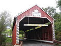
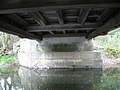
English: Snyder Covered Bridge No. 17 originally built in 1860 over the North Branch of Roaring Creek in Locust Township in Columbia County, Pennsylvania, in the United States.
|
This is a category about a place or building that is listed on the National Register of Historic Places in the United States of America. Its reference number is 79003188. |
Media in category "Snyder Covered Bridge"
The following 10 files are in this category, out of 10 total.
-
 Snyder Covered Bridge 1.JPG 3,648 × 2,736; 3.8 MB
-
 Snyder Covered Bridge 10.JPG 3,648 × 2,736; 2.3 MB
-
 Snyder Covered Bridge 2.JPG 3,648 × 2,736; 3.62 MB
-
 Snyder Covered Bridge 3.JPG 3,648 × 2,736; 1.74 MB
-
 Snyder Covered Bridge 4.jpg 6,756 × 3,574; 2.19 MB
-
 Snyder Covered Bridge 5.JPG 2,736 × 3,648; 2.07 MB
-
 Snyder Covered Bridge 6.JPG 3,648 × 2,736; 2.76 MB
-
 Snyder Covered Bridge 7.JPG 3,648 × 2,736; 2.34 MB
-
 Snyder Covered Bridge 8.JPG 2,736 × 3,648; 2.83 MB
-
 Snyder Covered Bridge 9.JPG 3,648 × 2,736; 3.06 MB


