Category:Soil shrink swell maps of Lot
Departments of Metropolitan France: Ariège [09] · Aude [11] · Charente [16] · Charente-Maritime [17] · Cher [18] · Corrèze [19] · Creuse [23] · Dordogne [24] · Eure-et-Loir [28] · Gard [30] · Haute-Garonne [31] · Gers [32] · Gironde [33] · Hérault [34] · Indre [36] · Indre-et-Loire [37] · Landes [40] · Loiret [45] · Lot [46] · Lot-et-Garonne [47] · Lozère [48] · Pyrénées-Atlantiques [64] · Hautes-Pyrénées [65] · Pyrénées-Orientales [66] · Deux-Sèvres [79] · Tarn [81] · Tarn-et-Garonne [82] · Vienne [86] · Haute-Vienne [87]
Media in category "Soil shrink swell maps of Lot"
The following 12 files are in this category, out of 12 total.
-
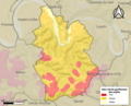 46001-Albas-argile.png 3,057 × 2,480; 4.49 MB
-
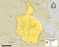 46002-Albiac-argile.png 3,057 × 2,480; 2.37 MB
-
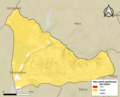 46003-Alvignac-argile.png 3,057 × 2,480; 3.05 MB
-
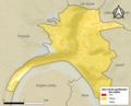
 46042-Cahors-argile.png 3,057 × 2,480; 6.03 MB
-
 46062-Castelfranc-argile.png 3,057 × 2,480; 2.69 MB
-
 46073-Concots-argile.png 3,057 × 2,480; 3.9 MB
-
 46127-Gourdon-argile.png 3,057 × 2,480; 5.27 MB
-
 46132-Issendolus-argile.png 3,057 × 2,480; 3.04 MB
-
 46137-Labastide-Marnhac-argile.png 3,057 × 2,480; 4.89 MB
-
 46152-Lamothe-Fénelon-argile.png 3,057 × 2,480; 3.72 MB
-
 46334-Le Vigan-argile.png 3,057 × 2,480; 5.09 MB
-
 47054-Castelmoron-sur-Lot-argile.jpg 3,057 × 2,480; 647 KB


