Category:South Rona

island in the Scottish Inner Hebrides   | |||||
| Upload media | |||||
| Instance of | |||||
|---|---|---|---|---|---|
| Part of | |||||
| Location | Highland, Scottish Highlands, Scotland | ||||
| Located in or next to body of water | |||||
| Population |
| ||||
| Area |
| ||||
| Different from | |||||
 | |||||
Media in category "South Rona"
The following 111 files are in this category, out of 111 total.
-
 A Resident of Rona - geograph.org.uk - 1046916.jpg 640 × 480; 147 KB
-
 Acairseid Mhor, Rona - geograph.org.uk - 718037.jpg 640 × 360; 68 KB
-
 Acairseid Mhor, South Rhona - geograph.org.uk - 99109.jpg 640 × 418; 36 KB
-
 Across the Inner Sound to Caol Rona - geograph.org.uk - 812699.jpg 640 × 480; 42 KB
-
 Admiralty Chart No 2570 Scotland, west coast Sound of Raasay and Inner Sound, Published 1857.jpg 12,246 × 8,331; 9.64 MB
-
 Aim for it - geograph.org.uk - 1364987.jpg 640 × 480; 94 KB
-
 An Caol looking to Eilean Tigh - geograph.org.uk - 937744.jpg 640 × 360; 58 KB
-
 An Teampull - geograph.org.uk - 1292808.jpg 640 × 480; 69 KB
-
 Arriving in Acairseid Mhor - geograph.org.uk - 1213796.jpg 640 × 436; 84 KB
-
 Bealach a' Chruigh - geograph.org.uk - 1121284.jpg 640 × 427; 90 KB
-

-
 Birch tree, Caol Rona - geograph.org.uk - 937756.jpg 640 × 360; 26 KB
-
 Breakfast below Manish Beg - geograph.org.uk - 1188966.jpg 640 × 480; 83 KB
-
 Cairn south of Beinn na h-Iolaire - geograph.org.uk - 923026.jpg 640 × 479; 232 KB
-
 Caol Rona - geograph.org.uk - 937832.jpg 640 × 360; 47 KB
-
 Caol Rona Bothy - geograph.org.uk - 230223.jpg 640 × 480; 87 KB
-
 Church Cave on Rona - geograph.org.uk - 1292616.jpg 480 × 640; 77 KB
-
 Church Cave, Rona - geograph.org.uk - 85300.jpg 640 × 480; 157 KB
-
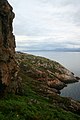
 Cleft on east coast of Rona - geograph.org.uk - 1378783.jpg 480 × 640; 98 KB
-
 Coastline of the Inner Sound - geograph.org.uk - 605296.jpg 640 × 425; 90 KB
-
 Contemplating the past on Rona - geograph.org.uk - 1241191.jpg 429 × 640; 94 KB
-
 Derelict Mission House Isle of Rona - geograph.org.uk - 985058.jpg 640 × 426; 111 KB
-
 Derelict Schoolhouse Rona - geograph.org.uk - 117984.jpg 640 × 411; 100 KB
-
 Dry harbour - geograph.org.uk - 1292759.jpg 640 × 480; 85 KB
-
 Dry Harbour, South Rona - geograph.org.uk - 599480.jpg 640 × 363; 101 KB
-
 Dyke on Fiurnean - geograph.org.uk - 326936.jpg 640 × 480; 59 KB
-
 East coast of Rona - geograph.org.uk - 231010.jpg 428 × 640; 62 KB
-
 End of the path north end of Raasay - geograph.org.uk - 821902.jpg 640 × 480; 74 KB
-
 Entrance to Acairseid Mhor - geograph.org.uk - 787647.jpg 640 × 426; 113 KB
-
 Footpath on Caol Rona - geograph.org.uk - 937764.jpg 640 × 480; 83 KB
-
 Footpath to Caol Rona - geograph.org.uk - 934941.jpg 640 × 360; 86 KB
-
 Glen below the Fladda to Caol Rona path - geograph.org.uk - 923022.jpg 640 × 480; 218 KB
-
 Gneissoutcroprona.jpg 640 × 427; 95 KB
-
 Heather clad hills on Rona - geograph.org.uk - 1046940.jpg 640 × 480; 129 KB
-
 Highland cow on Rona - geograph.org.uk - 1213808.jpg 640 × 435; 178 KB
-
 Hill in south Rona - geograph.org.uk - 828348.jpg 640 × 480; 73 KB
-
 Inner Sound - geograph.org.uk - 7794.jpg 640 × 297; 93 KB
-
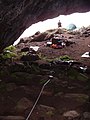
 Inside Church Cave, Rona - geograph.org.uk - 230858.jpg 640 × 427; 46 KB
-

-
 Isle viewed from cottage - geograph.org.uk - 962992.jpg 640 × 480; 57 KB
-
 Junction of the Umachan path - geograph.org.uk - 923041.jpg 640 × 480; 249 KB
-

-
 Leac Tressirnish - geograph.org.uk - 1246009.jpg 474 × 640; 79 KB
-
 Lighthouse on Rona - geograph.org.uk - 538456.jpg 640 × 426; 83 KB
-
 Loch Leathan from Ben Dearg - geograph.org.uk - 1034888.jpg 640 × 480; 136 KB
-
 Looking west to Raasay and Rona - geograph.org.uk - 953526.jpg 640 × 480; 164 KB
-
 Moorland north of Cuaig - geograph.org.uk - 1803043.jpg 640 × 480; 64 KB
-
 Moorland on Rona - geograph.org.uk - 1213853.jpg 640 × 434; 52 KB
-
 Moorland on Rona - geograph.org.uk - 828342.jpg 640 × 480; 82 KB
-
 Natural Font inside Church Cave, Rona - geograph.org.uk - 986276.jpg 640 × 480; 165 KB
-
 One of Rona's western headlands - geograph.org.uk - 1378738.jpg 640 × 347; 52 KB
-
 Ordnance Survey One-Inch Sheet 25 Portree, Published 1956.jpg 8,271 × 9,868; 8.63 MB
-
 Ordnance Survey One-Inch Sheet 25 Raasay & Applecross, Published 1947.jpg 10,459 × 12,911; 11.33 MB
-
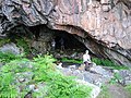
 Outside Church Cave on Rona - geograph.org.uk - 718058.jpg 640 × 480; 83 KB
-
 Outside Church Cave, Rona - geograph.org.uk - 993168.jpg 640 × 480; 125 KB
-

-
 Raasay shoreline - geograph.org.uk - 937724.jpg 640 × 360; 66 KB
-
 Road, Rona - geograph.org.uk - 724024.jpg 640 × 424; 73 KB
-
 Rock Outcrop - geograph.org.uk - 1213851.jpg 640 × 438; 82 KB
-
 Rocky Coastline and Jetty North of Sand - geograph.org.uk - 825873.jpg 640 × 412; 153 KB
-
 Rona and Fladda Markerpost - geograph.org.uk - 939443.jpg 640 × 360; 89 KB
-
 Rona and Raasay - geograph.org.uk - 1466563.jpg 640 × 425; 106 KB
-

-
 Rona letter box - geograph.org.uk - 230763.jpg 427 × 640; 60 KB
-
 Rona Lodge - geograph.org.uk - 1213832.jpg 640 × 438; 88 KB
-
 Rona Lodge - geograph.org.uk - 718047.jpg 640 × 360; 80 KB
-
 Rona Lodge - geograph.org.uk - 787717.jpg 640 × 480; 145 KB
-
 Rona Lodge, Isle of South Rona - geograph.org.uk - 94021.jpg 439 × 296; 76 KB
-
 Rona on the back ground - geograph.org.uk - 821928.jpg 640 × 480; 84 KB
-
 Rona, Lighthouse - geograph.org.uk - 1020649.jpg 640 × 427; 62 KB
-
 Rubha Dubh Chamais, Rona - geograph.org.uk - 231251.jpg 640 × 423; 54 KB
-
 Ruined croft, South Rona - geograph.org.uk - 718068.jpg 640 × 360; 62 KB
-
 Sand - geograph.org.uk - 1054152.jpg 640 × 415; 48 KB
-
 SD Raasay - geograph.org.uk - 3632942.jpg 640 × 480; 94 KB
-
 Sea Pinks on the Rocks near Sand - geograph.org.uk - 814697.jpg 640 × 400; 165 KB
-
 Seals off Northern end of Raasay - geograph.org.uk - 937813.jpg 640 × 480; 63 KB
-
 Service road, South Rona - geograph.org.uk - 718075.jpg 640 × 360; 69 KB
-
 Sgeir na Eun, Rona - geograph.org.uk - 231074.jpg 640 × 427; 57 KB
-
 Shed at Acairseid Mhor - geograph.org.uk - 787669.jpg 640 × 480; 171 KB
-
 Shieling on Rona - geograph.org.uk - 1213801.jpg 640 × 437; 98 KB
-
 Shieling, An Caol - geograph.org.uk - 937795.jpg 640 × 360; 78 KB
-
 Shore of the Inner Sound - geograph.org.uk - 182755.jpg 640 × 480; 75 KB
-
 Sithean Bhealaich Chumhaing - geograph.org.uk - 914873.jpg 640 × 480; 138 KB
-
 Skye from Meall an Tuim Bhuidhe - geograph.org.uk - 859861.jpg 640 × 480; 82 KB
-
 Soggy camping below Manish Beg - geograph.org.uk - 1627497.jpg 640 × 460; 112 KB
-
 Sunset off Rona - geograph.org.uk - 1046929.jpg 640 × 480; 56 KB
-
 Taigh Thormoid Dhuibh, Raasay - geograph.org.uk - 935011.jpg 640 × 360; 62 KB
-
 The coast road heading for Sand - geograph.org.uk - 1379760.jpg 1,000 × 669; 198 KB
-
 The Inner Sound from Applecross - geograph.org.uk - 134762.jpg 640 × 425; 102 KB
-
 Township on South Rona - geograph.org.uk - 718063.jpg 640 × 360; 75 KB
-
 Uamh Mor - geograph.org.uk - 230228.jpg 640 × 480; 91 KB
-
 Unloading kayaks in Scalpay Sound - geograph.org.uk - 1197203.jpg 640 × 480; 91 KB
-
 View across the Inner Sound - geograph.org.uk - 1379757.jpg 1,000 × 667; 265 KB
-
 View over the Inner Sound - geograph.org.uk - 1380206.jpg 1,000 × 657; 271 KB
-
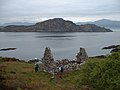
 View to Isle of Rona and mainland - geograph.org.uk - 33175.jpg 640 × 480; 82 KB
-
 View towards Lonbain - geograph.org.uk - 1380243.jpg 1,000 × 669; 260 KB
-
 View West from Dry Harbour Cottages Rona - geograph.org.uk - 984784.jpg 640 × 480; 111 KB
-
 West coast of Rona - geograph.org.uk - 787643.jpg 640 × 427; 109 KB
-
 Woods, east coast of Rona - geograph.org.uk - 715215.jpg 640 × 424; 53 KB
-
 Acairseid Mhor on Rona - geograph.org.uk - 718026.jpg 640 × 360; 59 KB
-
 Acairseid Mhor, Rona - geograph.org.uk - 230779.jpg 640 × 427; 65 KB
-
 Arriving at Acairseid Mhor - geograph.org.uk - 787650.jpg 640 × 426; 122 KB
-
 By Church Cave, Rona - geograph.org.uk - 230848.jpg 640 × 427; 53 KB
-
 Dry Harbour, Rona - geograph.org.uk - 230811.jpg 640 × 427; 88 KB
-
 Entrance to Acairseid Mhor on Rona - geograph.org.uk - 41869.jpg 640 × 480; 92 KB
-
 Entrance to Acairseid Mhor, Rona - geograph.org.uk - 230789.jpg 640 × 427; 66 KB
-
 Leaving Acairseid Mhor, South Rona - geograph.org.uk - 718085.jpg 640 × 360; 61 KB
-
 Meall Acairseid, Rona - geograph.org.uk - 230757.jpg 425 × 640; 69 KB
-
 Sgurr Ruadh - geograph.org.uk - 211275.jpg 640 × 480; 269 KB
-
 South East Corner of Rona - geograph.org.uk - 41867.jpg 640 × 480; 81 KB
-
 Wall above Holm - geograph.org.uk - 170700.jpg 640 × 480; 97 KB


