Category:Stèle à la Jeune Garde
| Object location | | View all coordinates using: OpenStreetMap |
|---|
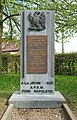
English: Located at the junction of Chemin du Lantimier and Chemin de Camuselle in Plancenoit, Belgium
 | |||||
| Upload media | |||||
| Instance of | |||||
|---|---|---|---|---|---|
| Location | Lasne, Arrondissement of Nivelles, Walloon Brabant, Walloon Region, Belgium | ||||
 | |||||
Media in category "Stèle à la Jeune Garde"
The following 5 files are in this category, out of 5 total.
-
 Belgique - Plancenoit - Stèle à la Jeune Garde - 01.jpg 2,448 × 3,673; 8.22 MB
-
 Belgique - Plancenoit - Stèle à la Jeune Garde - 02.jpg 2,592 × 3,872; 4.57 MB
-
 Belgique - Plancenoit - Stèle à la Jeune Garde - 03.jpg 2,431 × 3,795; 7.68 MB
-
 Belgique - Plancenoit - Stèle à la Jeune Garde - 04.jpg 1,968 × 3,372; 4.82 MB
-
 Belgique - Plancenoit - Stèle à la Jeune Garde - 05.jpg 2,624 × 2,496; 6.35 MB


