Category:St. Johannis (Ansbach)
| Object location | | View all coordinates using: OpenStreetMap |
|---|
building in Ansbach, Middle Franconia, Germany  .jpg) | |||||
| Upload media | |||||
| Instance of | |||||
|---|---|---|---|---|---|
| Location | Ansbach, Middle Franconia, Bavaria, Germany | ||||
| Street address |
| ||||
| Architectural style | |||||
| Heritage designation | |||||
 | |||||
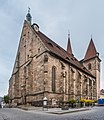
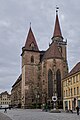
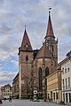
This is the category of the Bavarian Baudenkmal (cultural heritage monument) with the ID D-5-61-000-190 (Wikidata)
|
Deutsch: Ansbach - Martin-Luther-Platz 16 - Evang.-Luth. Pfarrkirche St. Johannis. Hallenkirche, Kirchenneubau 1410/1435, von zwei Türmen flankierter Chor, 1441/1508 von Endress Embhart d. Ä. und d. J. sowie Nikolaus Eseler, Türme bezeichnet 1504 und 1508, 1660 Einbau der Fürstengruft unter dem Chor, im 18. Jahrhundert purifizierende Veränderungen am Äußeren des Chors, mit Ausstattung.
Subcategories
This category has the following 2 subcategories, out of 2 total.
I
S
Media in category "St. Johannis (Ansbach)"
The following 61 files are in this category, out of 61 total.
-
 060407 03 Ansbach.jpg 480 × 640; 67 KB
-
 Adolf von Stählin - Wie Gottes Wort in der gegenwärtigen Kriegszeit uns zur Treue mahnt.pdf 800 × 1,212, 16 pages; 756 KB
-
 Ansbach - KMB - 16001000258504.jpg 573 × 780; 176 KB
-
 Ansbach Johanneskirche 4294.jpg 2,014 × 3,356; 1.22 MB
-
 Ansbach Markgraf-Karl-Wilhelm-Friedrich-Brunnen 873.jpg 2,964 × 4,446; 8.67 MB
-
 Ansbach St. Johannis 002.jpg 4,719 × 3,125; 8.59 MB
-
 Ansbach St. Johannis 833.jpg 3,264 × 4,896; 11.03 MB
-
 Ansbach St. Johannis 874.jpg 3,153 × 4,730; 10.18 MB
-
 Ansbach, Johanniskirche-001.jpg 3,264 × 4,928; 8.09 MB
-
 Ansbach, Johanniskirche-002.jpg 4,928 × 3,264; 8.66 MB
-
 Ansbach, Johanniskirche-006.jpg 3,264 × 4,928; 5.84 MB
-
 Ansbach, Kirche St.Johannis 012.jpg 4,496 × 3,000; 6.5 MB
-
 Ansbach, Kirche St.Johannis 013.jpg 4,496 × 3,000; 5.82 MB
-
 Ansbach, Kirche St.Johannis 014.jpg 3,000 × 4,496; 6.82 MB
-
 Bridge - Flickr - Stiller Beobachter (1).jpg 4,608 × 3,456; 5.38 MB
-
 Empty city - Flickr - Stiller Beobachter.jpg 2,871 × 2,165; 1.03 MB
-
 Evang.-Luth. Pfarrkirche St. Johannis Ansbach 20220106 0600.jpg 5,457 × 3,631; 14.01 MB
-
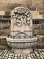 Güllbrunnen.jpg 480 × 640; 154 KB
-
 Hermann von Bezzel - Unsere Feinde.pdf 714 × 1,139, 16 pages; 1.03 MB
-
 Johanniskirche Ansbach.JPG 1,200 × 1,600; 448 KB
-
 Schaitbergerstraße, St. Johannis, von Norden Ansbach 20220102 0083.jpg 3,673 × 5,521; 17.7 MB
-
 St John the Baptist church in Ansbach (1).jpg 3,017 × 6,052; 7.19 MB
-
 St John the Baptist church in Ansbach (10).jpg 3,906 × 4,514; 8.94 MB
-
 St John the Baptist church in Ansbach (11).jpg 2,810 × 5,152; 8.09 MB
-
 St John the Baptist church in Ansbach (12).jpg 2,096 × 4,112; 4.92 MB
-
 St John the Baptist church in Ansbach (13).jpg 2,477 × 4,002; 6.41 MB
-
 St John the Baptist church in Ansbach (14).jpg 2,506 × 5,178; 9.29 MB
-
 St John the Baptist church in Ansbach (15).jpg 2,263 × 4,788; 6.33 MB
-
 St John the Baptist church in Ansbach (16).jpg 3,159 × 4,085; 6.91 MB
-
 St John the Baptist church in Ansbach (17).jpg 2,945 × 5,296; 7.69 MB
-
 St John the Baptist church in Ansbach (18).jpg 3,334 × 4,700; 7.89 MB
-
 St John the Baptist church in Ansbach (2).jpg 2,222 × 4,859; 6.96 MB
-
 St John the Baptist church in Ansbach (3).jpg 3,309 × 5,232; 11.98 MB
-
 St. Johannis - Lange Nacht 2016.jpg 3,024 × 4,032; 5.24 MB
-
 St. Johannis Church in Ansbach, Bavaria, Germany (5248425181) (2).jpg 752 × 1,024; 292 KB
-
 St. Johannis in Ansbach 01.jpg 2,904 × 4,968; 2.28 MB
-
 St. Johannis in Ansbach 02.jpg 3,080 × 5,472; 4.39 MB
-
 St. Johannis in Ansbach 03.jpg 5,472 × 3,080; 3.7 MB
-
 St. Johannis in Ansbach 05.jpg 3,080 × 5,472; 5.45 MB
-
 St. Johannis in Ansbach 06.jpg 2,881 × 5,119; 3.52 MB
-
 St. Johannis in Ansbach 07.jpg 2,974 × 5,284; 4.18 MB
-
 St. Johannis in Ansbach 08.jpg 5,472 × 3,080; 3.23 MB
-
 St. Johannis in Ansbach 14.jpg 2,960 × 4,480; 1.72 MB
-
 St. Johannis in Ansbach 15.jpg 3,080 × 5,472; 3.61 MB
-
 St. Johannis in Ansbach 16.jpg 3,080 × 5,472; 3.72 MB
-
 St. Johannis in Ansbach 17.jpg 3,368 × 6,000; 6.72 MB
-
 St. Johannis in Ansbach 18.jpg 3,316 × 5,908; 5.9 MB
-
 St. Johannis in Ansbach 20.jpg 3,368 × 6,000; 6.26 MB
-
 St. Johannis in Ansbach 21.jpg 6,000 × 3,368; 6.26 MB
-
 St. Johannis in Ansbach 22.jpg 3,264 × 5,256; 1.91 MB
-
 St. Johannis in Ansbach 23.jpg 5,472 × 3,080; 4.6 MB
-
 St. Johannis in Ansbach 24.jpg 2,952 × 4,544; 2.08 MB
-
 St. Johannis in Ansbach 29.jpg 3,080 × 5,472; 4.46 MB
-
 St. Johannis in Ansbach 31.jpg 3,080 × 5,472; 5.28 MB
-
 St. Johannis in Ansbach 32.jpg 2,936 × 5,217; 6.11 MB
-
 St. Johannis in Ansbach 33.jpg 3,368 × 6,000; 4.72 MB
-
 St. Johannis, St. Gumbertus, von Westen Ansbach 20220102 0164.jpg 3,604 × 5,416; 18.1 MB
-
 St. Johannis, von Osten Ansbach 20220102 0113.jpg 3,659 × 5,499; 17.22 MB
-
 St. Johannis, von Osten Ansbach 20220102 0422.jpg 5,187 × 3,451; 17.47 MB
-
 St. Johannis, von Osten Ansbach 20220102 0423.jpg 3,530 × 5,305; 16.08 MB
-
 W-1 - Ansbach (0BY) 5.JPG 2,560 × 1,920; 1.57 MB


.jpg)


.jpg)
.jpg)
.jpg)
.jpg)
.jpg)
.jpg)
.jpg)
.jpg)
.jpg)
.jpg)
.jpg)
.jpg)

_(2).jpg)


_5.JPG)