Category:St Andrew's, Trent, Dorset
| Object location | | View all coordinates using: OpenStreetMap |
|---|
church in Trent, Dorset, United Kingdom  | |||||
| Upload media | |||||
| Instance of | |||||
|---|---|---|---|---|---|
| Dedicated to | |||||
| Location | Trent, Dorset, South West England, England | ||||
| Diocese | |||||
| Heritage designation |
| ||||
| Inception |
| ||||
| Religion or worldview | |||||
 | |||||
Subcategories
This category has the following 3 subcategories, out of 3 total.
S
Media in category "St Andrew's, Trent, Dorset"
The following 37 files are in this category, out of 37 total.
-
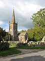
 Church of St Andrew - Trent - geograph.org.uk - 1277532.jpg 640 × 480; 85 KB
-
 Detail, St Andrew's Church - geograph.org.uk - 2277628.jpg 480 × 640; 106 KB
-
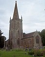
 St Andrew's Church, Trent - geograph.org.uk - 2137328.jpg 1,944 × 2,592; 1.62 MB
-
 St Andrew's Church, Trent - geograph.org.uk - 476700.jpg 499 × 640; 53 KB
-
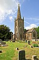
 St Andrew's Church, Trent - geograph.org.uk - 477440.jpg 640 × 480; 78 KB
-
 St Andrew's parish church - Trent - geograph.org.uk - 2422979.jpg 413 × 640; 313 KB
-

-
 St Andrew, Trent (30154074575).jpg 2,439 × 3,251; 1.35 MB
-
 St Andrew, Trent, churchyard (E) - geograph.org.uk - 3689220.jpg 480 × 640; 81 KB
-
 St Andrew, Trent, churchyard (iii) - geograph.org.uk - 3689828.jpg 640 × 480; 57 KB
-
 St Andrew, Trent, churchyard (v) - geograph.org.uk - 3689835.jpg 640 × 480; 110 KB
-
 St Andrew, Trent, churchyard (viii) - geograph.org.uk - 3689843.jpg 640 × 480; 123 KB
-
 St Andrew, Trent, churchyard (x) - geograph.org.uk - 3689847.jpg 640 × 480; 73 KB
-
 St Andrew, Trent, churchyard (xi) - geograph.org.uk - 3689850.jpg 640 × 480; 87 KB
-
 St Andrew, Trent, churchyard (xiii) - geograph.org.uk - 3689853.jpg 640 × 480; 68 KB
-
 St Andrew, Trent, September 2013 - geograph.org.uk - 3649170.jpg 640 × 468; 84 KB
-
 St Andrew, Trent, warning notice - geograph.org.uk - 3689304.jpg 640 × 480; 64 KB
-
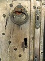
 St Andrew, Trent, west door - geograph.org.uk - 3689838.jpg 480 × 640; 94 KB
-
 The church of St Andrew, Trent, Dorset - geograph.org.uk - 3592430.jpg 1,600 × 1,200; 504 KB
-
 Trent Church (St. Andrews) (19608793344).jpg 4,592 × 3,056; 6.16 MB
-
 Trent Church (St. Andrews) (19608796974).jpg 4,592 × 3,056; 9.29 MB
-
 Trent Church (St. Andrews) (20044853709).jpg 4,592 × 3,056; 9.23 MB
-
 Trent Church (St. Andrews) (20205145956).jpg 4,592 × 3,056; 11.05 MB
-
 Trent Church (St. Andrews) (20205178946).jpg 3,056 × 4,592; 10.27 MB
-
 Trent Church (St. Andrews) (20231442525).jpg 3,056 × 4,592; 11.14 MB
-
 Trent Church (St. Andrews) (20237237471).jpg 3,056 × 4,592; 8.64 MB
-
 Trent church 1893.jpg 1,632 × 2,686; 723 KB
-
 Trent Parish Church - geograph.org.uk - 1355472.jpg 480 × 640; 53 KB
-
 Trent, Church of St Andrew - geograph.org.uk - 3934156.jpg 1,199 × 1,403; 1.5 MB
-
 Trent, Church of St Andrew - geograph.org.uk - 3934157.jpg 1,024 × 983; 289 KB
-
 Trent, churchyard path - geograph.org.uk - 2801514.jpg 480 × 640; 89 KB
-

-
 Trent, parish church of St. Andrew - geograph.org.uk - 531081.jpg 431 × 640; 94 KB
-

-
 Trent, remove your pattens and clogs - geograph.org.uk - 2801505.jpg 640 × 480; 68 KB
-
 Trent, St Andrew's Church - geograph.org.uk - 88714.jpg 451 × 614; 136 KB
-
 Trent, the church - geograph.org.uk - 2955566.jpg 427 × 640; 362 KB


.jpg)
_-_geograph.org.uk_-_3689220.jpg)
_-_geograph.org.uk_-_3689828.jpg)
_-_geograph.org.uk_-_3689835.jpg)
_-_geograph.org.uk_-_3689843.jpg)
_-_geograph.org.uk_-_3689847.jpg)
_-_geograph.org.uk_-_3689850.jpg)
_-_geograph.org.uk_-_3689853.jpg)


_(19608793344).jpg)
_(19608796974).jpg)
_(20044853709).jpg)
_(20205145956).jpg)
_(20205178946).jpg)
_(20231442525).jpg)
_(20237237471).jpg)


