Category:St Mary's church, Syde
| Object location | | View all coordinates using: OpenStreetMap |
|---|
church in Cotswold, United Kingdom  | |||||
| Upload media | |||||
| Instance of | |||||
|---|---|---|---|---|---|
| Dedicated to | |||||
| Location | Syde, Cotswold, Gloucestershire, South West England, England | ||||
| Diocese | |||||
| Heritage designation |
| ||||
| Inception |
| ||||
| Religion or worldview | |||||
 | |||||
Subcategories
This category has only the following subcategory.
S
Media in category "St Mary's church, Syde"
The following 11 files are in this category, out of 11 total.
-
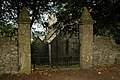 Entrance gate to Syde church - geograph.org.uk - 584529.jpg 640 × 426; 146 KB
-
 Syde Church (St. Mary the Virgin) (29299187874).jpg 4,000 × 6,000; 6.57 MB
-
 Syde Church (St. Mary the Virgin) (29299919753).jpg 6,000 × 4,000; 6.8 MB
-
 Syde Church (St. Mary the Virgin) (29632495860).jpg 6,000 × 4,000; 6.64 MB
-
 Syde Church (St. Mary the Virgin) (29632497040).jpg 6,000 × 4,000; 6.21 MB
-
 Syde Church (St. Mary the Virgin) (29843257811).jpg 6,000 × 4,000; 6.5 MB
-
 Syde Church (St. Mary the Virgin) (29891910046).jpg 6,000 × 4,000; 6.1 MB
-
 Syde Church (St. Mary the Virgin) (29891914246).jpg 4,000 × 6,000; 6.98 MB
-
 Syde Church (St. Mary the Virgin) (29926543885).jpg 6,000 × 4,000; 25.33 MB
-
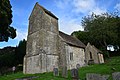
 Syde Church - geograph.org.uk - 584521.jpg 640 × 426; 119 KB
-
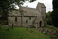
 The Church of St Mary the Virgin at Syde 1998 - geograph.org.uk - 2779786.jpg 1,024 × 684; 219 KB

_(29299187874).jpg)
_(29299919753).jpg)
_(29632495860).jpg)
_(29632497040).jpg)
_(29843257811).jpg)
_(29891910046).jpg)
_(29891914246).jpg)
_(29926543885).jpg)
