Category:St Paul's Road bridge, Rock Ferry
| Object location | | View all coordinates using: OpenStreetMap |
|---|
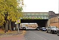
This bridge carries the Wirral Line over St Paul's Road, Rock Ferry. It is designated CCS1/54 on the Rock Ferry to Birkenhead Woodside branch (CCS1) of the Chester & Rock Ferry Line and is 13.73 miles from the datum at Chester.
Media in category "St Paul's Road bridge, Rock Ferry"
The following 5 files are in this category, out of 5 total.
-
 Benchmark at St Paul's Road bridge, Rock Ferry.jpg 3,102 × 4,954; 7.92 MB
-
 Rail bridge, St Paul's Road, Rock Ferry.JPG 3,648 × 2,736; 3.68 MB
-
 St Paul's Road bridge, Rock Ferry 1.jpg 5,004 × 3,297; 9.51 MB
-
 St Paul's Road bridge, Rock Ferry 2.jpg 5,322 × 3,548; 12.3 MB
-
 St Paul's Road bridge, Rock Ferry 3.jpg 4,926 × 3,366; 9.98 MB


