Category:Staden train station
| Object location | | View all coordinates using: OpenStreetMap |
|---|
railway station in Belgium  | |||||
| Upload media | |||||
| Instance of | |||||
|---|---|---|---|---|---|
| Location | Staden, Arrondissement of Roeselare, West Flanders, Flemish Region, Belgium | ||||
| Date of official opening |
| ||||
| Date of official closure |
| ||||
| Elevation above sea level |
| ||||
| Connecting line | |||||
 | |||||
Français : La gare de Staden est une gare ferroviaire belge (hors service) de la ligne 63, de Torhout à Ypres (hors service), située au centre du bourg de Staden, section de la commune du même nom, dans la province de Flandre-Occidentale en région flamande.
Nederlands: Station Staden is een voormalig spoorwegstation in de gemeente Staden. Het lag aan spoorlijn 63.
Media in category "Staden train station"
The following 7 files are in this category, out of 7 total.
-
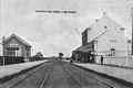 Gare-Staden-intérieur-CPancienne.jpg 978 × 653; 493 KB
-
 Spoorlijn 63 R01.jpg 2,584 × 3,890; 7.65 MB
-
 Spoorlijn 63 R05.jpg 4,227 × 2,532; 4.8 MB
-
 Spoorlijn 63 te Staden 1.JPG 3,456 × 4,608; 5.1 MB
-
 Spoorlijn 63 te Staden 2.JPG 3,456 × 4,608; 4.78 MB
-
 Stationsgebouw Staden.JPG 3,456 × 4,608; 1,019 KB
-
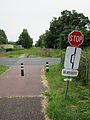 Vrijbosroute te Staden.JPG 3,456 × 4,608; 4.71 MB


