Category:Starke County Bridge 700E
The Starke County Bridge on 700E is 615 feet (187 m) north of Indiana Rte 8, 3 miles (4.8 km) east of Knox, Starke County, Indiana.
| Camera location | | View all coordinates using: OpenStreetMap |
|---|
 | |||||
| Upload media | |||||
| Instance of | |||||
|---|---|---|---|---|---|
| Location | Starke County, Indiana | ||||
| Crosses | |||||
 | |||||
Media in category "Starke County Bridge 700E"
The following 8 files are in this category, out of 8 total.
-
 700 East PA090116.jpg 1,984 × 1,488; 668 KB
-
 700 East PA090117.jpg 1,984 × 1,488; 684 KB
-
 Guardrail PA090122.jpg 1,984 × 1,488; 637 KB
-
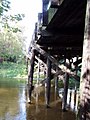 Piers PA090118.jpg 1,488 × 1,984; 634 KB
-
 Piers PA090119.jpg 1,984 × 1,488; 697 KB
-
 Piers PA090120.jpg 1,984 × 1,488; 626 KB
-
 Road deck PA090121.jpg 1,984 × 1,488; 620 KB
-
 Yellow River PA090123.jpg 1,984 × 1,488; 1.96 MB


