Category:Staunton, Nottinghamshire
English: Staunton is a civil parish in the Newark and Sherwood district, in the county of Nottinghamshire, England.
civil parish in Newark and Sherwood, Nottinghamshire, England | |||||
| Upload media | |||||
| Instance of | |||||
|---|---|---|---|---|---|
| Named after | |||||
| Location | Newark and Sherwood, Nottinghamshire, East Midlands, England | ||||
 | |||||
Subcategories
This category has the following 2 subcategories, out of 2 total.
S
- Staunton Hall (10 F)
Media in category "Staunton, Nottinghamshire"
The following 91 files are in this category, out of 91 total.
-
 Approach to a former occupation crossing - geograph.org.uk - 6111402.jpg 1,024 × 768; 217 KB
-
 Back Dyke - geograph.org.uk - 2927843.jpg 640 × 480; 91 KB
-
 Back Dyke - geograph.org.uk - 3180449.jpg 640 × 427; 105 KB
-
 Belvoir Angel - Hannah Musson - geograph.org.uk - 3573215.jpg 640 × 427; 129 KB
-
 Belvoir Angel - Mary Musson - geograph.org.uk - 3573217.jpg 640 × 427; 125 KB
-
 Belvoir Angel - Thomas Musson - geograph.org.uk - 3573221.jpg 640 × 427; 132 KB
-
 Belvoir Angel gravestone, Staunton - geograph.org.uk - 3936045.jpg 1,280 × 960; 458 KB
-
 Belvoir Angel gravestone, Staunton - geograph.org.uk - 3936048.jpg 960 × 1,280; 499 KB
-
 Belvoir Angel gravestone, Staunton - geograph.org.uk - 3936050.jpg 960 × 1,280; 522 KB
-
 Belvoir Angel gravestone, Staunton - geograph.org.uk - 3936055.jpg 1,280 × 960; 529 KB
-
 Cereal field and Fourteen Acre Covert - geograph.org.uk - 6111408.jpg 1,024 × 768; 154 KB
-
 Chapelside Farm, Staunton in the Vale - geograph.org.uk - 3253090.jpg 640 × 480; 114 KB
-
 Church path - geograph.org.uk - 3178940.jpg 640 × 427; 138 KB
-
 Clearing in Staunton Quarry Nature Reserve - geograph.org.uk - 2893857.jpg 1,024 × 768; 143 KB
-
 Corner Farm, Staunton - geograph.org.uk - 3936062.jpg 1,280 × 960; 266 KB
-
 Corner Farm, Staunton in the Vale - geograph.org.uk - 5842471.jpg 1,280 × 850; 516 KB
-
 Crossroads at Staunton in the Vale - geograph.org.uk - 3253081.jpg 640 × 480; 81 KB
-
 Datestone, Staunton Hall Lodge - geograph.org.uk - 3935599.jpg 1,280 × 960; 279 KB
-
 East window, St Mary's church, Staunton in The Vale - geograph.org.uk - 4765357.jpg 1,912 × 3,492; 3.54 MB
-

-
 Farm building, Staunton Hall - geograph.org.uk - 3935604.jpg 1,280 × 960; 434 KB
-
 Farm track at Staunton in the Vale - geograph.org.uk - 2893904.jpg 1,024 × 768; 276 KB
-
 Farmland off Normanton Road - geograph.org.uk - 2927898.jpg 640 × 480; 77 KB
-
 Field entrance, Staunton in the Vale - geograph.org.uk - 2927864.jpg 640 × 480; 82 KB
-
 Folly Hill - geograph.org.uk - 2974641.jpg 640 × 427; 84 KB
-
 Folly Hill footpath - geograph.org.uk - 930046.jpg 640 × 427; 92 KB
-
 Footpath - last used^ - geograph.org.uk - 352154.jpg 640 × 480; 120 KB
-
 Footpath alongside the River Devon - geograph.org.uk - 6111419.jpg 1,024 × 768; 324 KB
-

-
 Footpath off Grange Lane - geograph.org.uk - 2927841.jpg 640 × 480; 106 KB
-
 Footpath over fields - geograph.org.uk - 2927888.jpg 640 × 480; 82 KB
-
 Garage, wall and urn, Staunton Hall - geograph.org.uk - 3935654.jpg 1,280 × 960; 519 KB
-
 Grain silos and farm track - geograph.org.uk - 2893933.jpg 1,024 × 768; 219 KB
-
 Grange Lane heading south - geograph.org.uk - 2927848.jpg 640 × 480; 58 KB
-
 Grange Lane nears Back Dyke - geograph.org.uk - 5132876.jpg 640 × 480; 39 KB
-
 Grazing near Staunton in the Vale - geograph.org.uk - 2927854.jpg 640 × 480; 55 KB
-
 Gypsum blocks on the old railway bridge - geograph.org.uk - 6111387.jpg 1,024 × 768; 249 KB
-
 High Street, Staunton in the Vale - geograph.org.uk - 3253103.jpg 640 × 480; 93 KB
-
 Interior, St Mary's church, Staunton in The Vale - geograph.org.uk - 4765360.jpg 4,136 × 2,752; 4.1 MB
-
 Interpretation Board for the Lancaster W4270 Memorial - geograph.org.uk - 2756022.jpg 2,048 × 1,536; 720 KB
-

-

-

-
 Nettle Bed Path - geograph.org.uk - 239834.jpg 640 × 480; 100 KB
-
 New plantation - geograph.org.uk - 2893948.jpg 1,024 × 768; 177 KB
-
 New Road near Staunton in the Vale - geograph.org.uk - 1031292.jpg 640 × 466; 88 KB
-
 Newly installed cattle grid - geograph.org.uk - 6111399.jpg 1,024 × 768; 169 KB
-
 Normanton Lane near Normanton Thorns - geograph.org.uk - 5570224.jpg 640 × 427; 86 KB
-
 Normanton Thorns - geograph.org.uk - 2927896.jpg 640 × 480; 133 KB
-
 Normanton Thorns - geograph.org.uk - 2974636.jpg 640 × 427; 105 KB
-
 North Edge of Big Sykes Covert - geograph.org.uk - 2612472.jpg 1,280 × 960; 692 KB
-
 Path along a former railway line - geograph.org.uk - 6111412.jpg 1,024 × 768; 241 KB
-
 Plantation and Scrub - geograph.org.uk - 2894123.jpg 1,024 × 768; 303 KB
-

-

-

-
 Rat skull - geograph.org.uk - 3180445.jpg 640 × 427; 118 KB
-
 Renovated Lancaster W4270 Memorial - geograph.org.uk - 2756038.jpg 3,264 × 2,448; 3.22 MB
-
 River Devon, Staunton in the Vale - geograph.org.uk - 2927869.jpg 640 × 480; 119 KB
-
 Road to Staunton Works - geograph.org.uk - 2927861.jpg 640 × 480; 47 KB
-
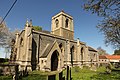
 St Mary's Church, Staunton in the Vale - geograph.org.uk - 3935644.jpg 1,280 × 960; 678 KB
-
 St Mary's Church, Staunton in the Vale - geograph.org.uk - 3935650.jpg 896 × 1,280; 453 KB
-
 St Mary's Church, Staunton in the Vale - geograph.org.uk - 3936054.jpg 1,280 × 1,280; 628 KB
-
 St Mary's Church, Staunton in the Vale - geograph.org.uk - 3936057.jpg 1,280 × 855; 404 KB
-
 St Mary's Church, Staunton-in-the-Vale - geograph.org.uk - 6154196.jpg 1,936 × 2,592; 1.77 MB
-
 St.Mary's church - geograph.org.uk - 4450406.jpg 1,024 × 683; 249 KB
-
 St.Mary's church - geograph.org.uk - 4450410.jpg 1,024 × 683; 288 KB
-
 Staunton Arms inn sign - geograph.org.uk - 5842473.jpg 1,280 × 1,280; 429 KB
-
 Staunton Hall - geograph.org.uk - 3936042.jpg 1,280 × 960; 406 KB
-
 Staunton Hall - geograph.org.uk - 5842469.jpg 1,280 × 856; 577 KB
-
 Staunton Hall cottage - geograph.org.uk - 3180382.jpg 640 × 427; 97 KB
-
 Staunton Hall Lodge and gates - geograph.org.uk - 3935573.jpg 1,280 × 960; 380 KB
-
 Staunton Park - geograph.org.uk - 2893270.jpg 1,024 × 768; 201 KB
-
 Staunton Quarry Nature Reserve - geograph.org.uk - 3180441.jpg 640 × 427; 95 KB
-
 Teepee in the woods - geograph.org.uk - 2893232.jpg 1,024 × 768; 324 KB
-
 The beginning of the footpath to Long Bennington - geograph.org.uk - 2893848.jpg 1,024 × 768; 143 KB
-
 The beginning of the path - geograph.org.uk - 2893940.jpg 1,024 × 768; 276 KB
-
 The bend at Normanton Thorns - geograph.org.uk - 2894161.jpg 1,024 × 768; 181 KB
-

-
 The Old Rectory, Staunton in the Vale - geograph.org.uk - 3935566.jpg 934 × 1,280; 400 KB
-
 The Staunton Arms - geograph.org.uk - 3180434.jpg 640 × 427; 97 KB
-
 The Staunton Arms - geograph.org.uk - 3936064.jpg 1,280 × 943; 241 KB
-
 The Staunton Arms - geograph.org.uk - 5132877.jpg 640 × 480; 71 KB
-

-
 The track to Follyhill Cottage - geograph.org.uk - 2894128.jpg 1,024 × 768; 185 KB
-

-
 Twisty road towards Normanton - geograph.org.uk - 2927895.jpg 640 × 480; 60 KB
-
 View towards Staunton in the Vale - geograph.org.uk - 2893255.jpg 1,024 × 768; 148 KB
-
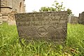
 William Staunton memorial - geograph.org.uk - 3180388.jpg 427 × 640; 105 KB
-

-
 Works from approach road near Staunton - geograph.org.uk - 376910.jpg 640 × 480; 139 KB


