Category:Stawley
English: Stawley is a village and civil parish in Somerset, England, situated west of Taunton in the Taunton Deane district. The parish has a population of 305 and includes the village of Kittisford and the hamlets of Appley and Greenham.
village and civil parish in Somerset, United Kingdom  | |||||
| Upload media | |||||
| Instance of | |||||
|---|---|---|---|---|---|
| Location | Somerset West and Taunton, Somerset, South West England, England | ||||
| Population |
| ||||
 | |||||
Subcategories
This category has the following 8 subcategories, out of 8 total.
C
- Cothay Manor (10 F)
G
- Greenham Barton (1 F)
H
- Hill Farm, Stawley (1 F)
K
- Kittisford Barton (1 F)
M
Media in category "Stawley"
The following 200 files are in this category, out of 273 total.
(previous page) (next page)-
 A tunnel through the overhanging hedges, east of Kittisford - geograph.org.uk - 6704495.jpg 3,200 × 2,395; 3.53 MB
-
 Appley , Appley Village Hall - geograph.org.uk - 1332737.jpg 640 × 480; 82 KB
-
 Appley , Country Lane ^ Pub - geograph.org.uk - 4031447.jpg 4,288 × 2,848; 5.91 MB
-
 Appley , Country Road - geograph.org.uk - 1332739.jpg 640 × 480; 85 KB
-
 Appley , Country Road - geograph.org.uk - 1332745.jpg 640 × 480; 51 KB
-

-
 Appley , Farm Track - geograph.org.uk - 4022443.jpg 4,288 × 2,848; 5.86 MB
-

-
 Appley , Muddy Path - geograph.org.uk - 4022436.jpg 2,848 × 4,288; 7 MB
-
 Appley , Road ^ Deer - geograph.org.uk - 4031441.jpg 4,288 × 2,848; 5.49 MB
-

-
 Appley , Telephone Box - geograph.org.uk - 4031449.jpg 2,848 × 4,288; 5.89 MB
-
 Appley , The Village Shop - geograph.org.uk - 4022417.jpg 4,288 × 2,848; 6.4 MB
-
 Appley , Village Road - geograph.org.uk - 4022419.jpg 4,288 × 2,848; 5.91 MB
-
 Appley , Village Road - geograph.org.uk - 4022423.jpg 4,288 × 2,848; 6.35 MB
-
 Appley , Village Road - geograph.org.uk - 4022428.jpg 4,288 × 2,848; 6.91 MB
-
 Appley Court Farm - geograph.org.uk - 3819363.jpg 1,024 × 769; 112 KB
-
 Appley Cross - geograph.org.uk - 5103505.jpg 1,600 × 1,201; 732 KB
-
 Appley Cross at the crossroads - geograph.org.uk - 6703914.jpg 3,200 × 2,133; 2.91 MB
-
 Appley Pavilion - geograph.org.uk - 6703912.jpg 3,200 × 2,400; 2.7 MB
-
 Approaching a blind bend in the road - geograph.org.uk - 4618099.jpg 640 × 480; 189 KB
-
 Barley near Greenham - geograph.org.uk - 1939857.jpg 640 × 448; 84 KB
-
 Barn at Kittisford Barton - geograph.org.uk - 6704517.jpg 3,200 × 2,407; 2.55 MB
-
 Barn at Morses farm, Appley - geograph.org.uk - 6703917.jpg 3,200 × 2,400; 3.05 MB
-
 Barn conversion at Kittisford Barton - geograph.org.uk - 6704516.jpg 3,200 × 2,400; 2.45 MB
-
 Beardley Farm - geograph.org.uk - 3819699.jpg 1,024 × 768; 193 KB
-
 Bridge at foot of Bishop's Hill, Greenham - geograph.org.uk - 6668770.jpg 1,600 × 1,200; 1.04 MB
-

-
 Bridge over River Tone at Greenham - geograph.org.uk - 5103080.jpg 1,600 × 1,200; 795 KB
-
 Bridge over Stockingford Water - geograph.org.uk - 6703934.jpg 3,200 × 2,289; 3.2 MB
-
 Building at Wiseburrow Farm - geograph.org.uk - 4839341.jpg 1,024 × 816; 304 KB
-
 Bullock Field Hill - geograph.org.uk - 6704522.jpg 3,200 × 2,400; 3.01 MB
-
 Coates Farm, Kittisford - geograph.org.uk - 3819174.jpg 1,024 × 768; 200 KB
-
 Cockland Hill - geograph.org.uk - 3410354.jpg 640 × 480; 208 KB
-
 Conybeer Copse - geograph.org.uk - 6704533.jpg 3,200 × 2,396; 2.12 MB
-
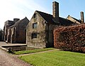 Cothay Manor - geograph.org.uk - 4839310.jpg 1,024 × 791; 238 KB
-
 Cothay Manor - geograph.org.uk - 5063492.jpg 1,000 × 662; 866 KB
-
 Cothay Manor - geograph.org.uk - 5063499.jpg 1,000 × 662; 805 KB
-
 Cothay Manor - geograph.org.uk - 5063957.jpg 662 × 1,000; 861 KB
-
 Cothay Manor - geograph.org.uk - 5063964.jpg 662 × 1,000; 953 KB
-
 Cothay Manor - geograph.org.uk - 5064131.jpg 1,000 × 662; 867 KB
-
 Cothay Manor - geograph.org.uk - 5064132.jpg 662 × 1,000; 974 KB
-
 Cothay Manor - geograph.org.uk - 5065758.jpg 1,000 × 662; 733 KB
-
 Cothay Manor - geograph.org.uk - 5065768.jpg 662 × 1,000; 952 KB
-
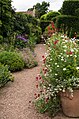
 Cothay Manor gardens - geograph.org.uk - 5063977.jpg 662 × 1,000; 1,023 KB
-
 Cothay Manor gardens - geograph.org.uk - 5064124.jpg 662 × 1,000; 853 KB
-
 Cothay Manor gardens - geograph.org.uk - 5064137.jpg 1,000 × 662; 834 KB
-
 Cothay Manor gardens - geograph.org.uk - 5064140.jpg 662 × 1,000; 926 KB
-
 Cothay Manor gardens - geograph.org.uk - 5064198.jpg 662 × 1,000; 979 KB
-
 Cothay Manor gardens - geograph.org.uk - 5064202.jpg 662 × 1,000; 935 KB
-
 Cothay Manor gardens - geograph.org.uk - 5064580.jpg 662 × 1,000; 997 KB
-
 Cothay Manor gardens - geograph.org.uk - 5064608.jpg 662 × 1,000; 928 KB
-
 Cothay Manor gardens - geograph.org.uk - 5065745.jpg 1,000 × 662; 1 MB
-
 Cothay Manor gardens - geograph.org.uk - 5065748.jpg 1,000 × 662; 864 KB
-
 Cothay Manor gardens - geograph.org.uk - 5065752.jpg 1,000 × 662; 978 KB
-
 Cothay Manor gardens - geograph.org.uk - 5065754.jpg 662 × 1,000; 925 KB
-
 Cothay Manor gardens - geograph.org.uk - 5065756.jpg 1,000 × 662; 824 KB
-
 Cothay Manor, Kittisford (3) - geograph.org.uk - 3155693.jpg 640 × 427; 324 KB
-
 Cottage, Tracebridge - geograph.org.uk - 1942301.jpg 507 × 640; 113 KB
-
 Country road junction - geograph.org.uk - 2789197.jpg 640 × 480; 84 KB
-
 Countryside east of the Tone from the air - geograph.org.uk - 5687647.jpg 2,628 × 1,908; 1.2 MB
-
 Countryside north of Higher Greenham - geograph.org.uk - 1939785.jpg 640 × 451; 80 KB
-
 Distant View of Kittisford - geograph.org.uk - 4375865.jpg 2,814 × 1,964; 1.23 MB
-
 Drive, Cothay Manor - geograph.org.uk - 1939802.jpg 640 × 480; 106 KB
-
 Drive, to Greenham Hall - geograph.org.uk - 1267290.jpg 640 × 480; 116 KB
-
 Duckham's Bridge over River Tone - geograph.org.uk - 6705366.jpg 3,200 × 2,403; 3.32 MB
-
 Early daffodils, near Kittisford Mead - geograph.org.uk - 4839335.jpg 1,024 × 826; 391 KB
-
 Entrance drive, Cothay Manor - geograph.org.uk - 4839325.jpg 1,024 × 768; 325 KB
-
 Entrance gate for Greenham Hall - geograph.org.uk - 6703910.jpg 3,200 × 2,400; 3.04 MB
-
 Entrance to Appley - geograph.org.uk - 2789185.jpg 640 × 480; 110 KB
-
 Entrance to Cothay Manor - geograph.org.uk - 4031597.jpg 640 × 480; 199 KB
-
 Entrance to Greenham - geograph.org.uk - 2789189.jpg 640 × 466; 106 KB
-
 Entrance to Stawley - geograph.org.uk - 2789180.jpg 640 × 480; 85 KB
-
 Field above Moor Copse - geograph.org.uk - 1940386.jpg 640 × 480; 102 KB
-
 Field and barn near Kittisford - geograph.org.uk - 1939860.jpg 640 × 427; 71 KB
-
 Field at Greenham - geograph.org.uk - 6668786.jpg 1,600 × 1,200; 817 KB
-
 Field in the floodplain of the River Tone at Greenham - geograph.org.uk - 5103110.jpg 1,600 × 1,200; 868 KB
-
 Field near Kittisford Farm - geograph.org.uk - 1941290.jpg 640 × 443; 77 KB
-
 Footpath at Greenham - geograph.org.uk - 6668783.jpg 1,200 × 1,600; 1.09 MB
-
 Footpath sign on Bullock Field Hill - geograph.org.uk - 6704525.jpg 3,200 × 2,562; 2.89 MB
-
 Ford and footbridge on Watery Lane - geograph.org.uk - 3410350.jpg 640 × 480; 208 KB
-
 Ford and footbridge on Watery Lane - geograph.org.uk - 3818893.jpg 1,024 × 768; 260 KB
-
 From Fisher's Hill - geograph.org.uk - 1939168.jpg 640 × 449; 104 KB
-
 Gateway at sharp bend in road, Great Brimley - geograph.org.uk - 6703932.jpg 3,200 × 1,775; 1.75 MB
-
 Gateway to Rectory Farm, Kittisford - geograph.org.uk - 6704499.jpg 3,200 × 2,400; 3.36 MB
-
 Greater Stitchwort - geograph.org.uk - 1267420.jpg 640 × 480; 130 KB
-

-
 Greenham Hall - geograph.org.uk - 1267298.jpg 640 × 480; 98 KB
-
 Gypsy Cross, Bathealton - geograph.org.uk - 3812885.jpg 3,968 × 2,976; 2.22 MB
-
 Hedges at different stages of regrowth, north of Appley - geograph.org.uk - 6703924.jpg 3,200 × 2,400; 2.89 MB
-
 Higher Greenham from Fisher's Hill - geograph.org.uk - 1939789.jpg 640 × 480; 92 KB
-
 Hillside near Gipsy Cross - geograph.org.uk - 1941254.jpg 640 × 440; 77 KB
-
 House on south-east edge of Kittisford Barton - geograph.org.uk - 6704510.jpg 3,200 × 2,400; 2.88 MB
-
 Interior of St Peter's Church, Greenham - geograph.org.uk - 5103101.jpg 1,600 × 1,200; 671 KB
-
 Junction on Piley Lane - geograph.org.uk - 4839316.jpg 1,024 × 768; 284 KB
-
 Kittisford , Coates Farm - geograph.org.uk - 4031401.jpg 4,288 × 2,848; 6.46 MB
-
 Kittisford , Country Lane - geograph.org.uk - 4031395.jpg 4,288 × 2,848; 6.87 MB
-
 Kittisford , Kittisford Booster Distribution Site - geograph.org.uk - 4031398.jpg 2,848 × 4,288; 6.51 MB
-
 Kittisford , Newhouse Farm - geograph.org.uk - 4031389.jpg 4,288 × 2,848; 6.55 MB
-
 Kittisford , Village Sign - geograph.org.uk - 4031405.jpg 4,288 × 2,848; 6.22 MB
-
 Kittisford churchyard - geograph.org.uk - 6704494.jpg 3,200 × 2,400; 2.92 MB
-
 Lane at Beardley Farm - geograph.org.uk - 1940409.jpg 640 × 386; 69 KB
-
 Lane at Greenham Barton - geograph.org.uk - 1871021.jpg 640 × 480; 212 KB
-
 Lime kilns at Wiseburrow - geograph.org.uk - 5103056.jpg 1,600 × 1,200; 879 KB
-
 Looking west to Appley Cross - geograph.org.uk - 5103497.jpg 1,600 × 1,281; 841 KB
-
 Main road through Appley - geograph.org.uk - 3819402.jpg 1,024 × 768; 178 KB
-
 Mary Australie Kelly circa 1910.jpg 800 × 924; 110 KB
-
 Memorial on west wall of St Peter's Church, Greenham - geograph.org.uk - 5103104.jpg 1,600 × 1,200; 587 KB
-
 Mid Devon , House ^ Countryside - geograph.org.uk - 2803472.jpg 4,288 × 2,848; 5.36 MB
-
 Mid Devon , Sheep Grazing ^ Scenery - geograph.org.uk - 2803461.jpg 4,288 × 2,848; 4.93 MB
-
 Mid Devon , Sheep Grazing ^ Scenery - geograph.org.uk - 2803468.jpg 4,288 × 2,848; 5.71 MB
-
 Minor crossroads at Stawley - geograph.org.uk - 4985059.jpg 1,024 × 768; 309 KB
-
 Minor road to Thorne St Margaret - geograph.org.uk - 4839625.jpg 1,024 × 768; 236 KB
-
 Minor road, to Higher Greenham - geograph.org.uk - 1267405.jpg 640 × 480; 120 KB
-
 Morses Farm Appley - geograph.org.uk - 6703916.jpg 3,200 × 1,833; 2.18 MB
-
 Newhouse Farm - geograph.org.uk - 3819154.jpg 1,024 × 813; 136 KB
-
 Ornamental trees east of Stawley - geograph.org.uk - 6704527.jpg 3,200 × 2,397; 3.27 MB
-
 Park, Greenham Hall - geograph.org.uk - 1939854.jpg 640 × 480; 93 KB
-
 Pasture at Stawley - geograph.org.uk - 4985039.jpg 1,024 × 802; 215 KB
-
 Phone box in Appley - geograph.org.uk - 6703923.jpg 3,200 × 2,400; 3.17 MB
-
 Poleshill Ford - geograph.org.uk - 5135600.jpg 1,440 × 960; 2.45 MB
-
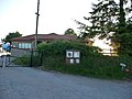
 Post office and shop and car park, Appley Cross - geograph.org.uk - 5103507.jpg 1,600 × 1,200; 808 KB
-

-
 River Tone at Greenham - geograph.org.uk - 5103091.jpg 1,600 × 1,200; 873 KB
-
 Road and hedges on Bullock Field Hill - geograph.org.uk - 6704504.jpg 3,200 × 2,400; 3.34 MB
-
 Road from Little Brimley to Great Brimley - geograph.org.uk - 6703927.jpg 3,200 × 2,403; 3.36 MB
-
 Road junction - geograph.org.uk - 2789177.jpg 640 × 448; 90 KB
-
 Road junction east of Greenham - geograph.org.uk - 6668789.jpg 1,600 × 1,200; 1.06 MB
-
 Road junction in Appley - geograph.org.uk - 6703920.jpg 3,200 × 2,405; 2.53 MB
-
 Road junction near Meadow Mere - geograph.org.uk - 6668805.jpg 1,600 × 1,200; 1 MB
-
 Roadside cottage, Tracebridge - geograph.org.uk - 3819442.jpg 1,024 × 768; 193 KB
-
 Rough pasture west of Great Brimley - geograph.org.uk - 6703929.jpg 3,200 × 2,400; 3.08 MB
-
 Ruined buildings at Wiseburrow Farm - geograph.org.uk - 4839620.jpg 1,024 × 815; 297 KB
-
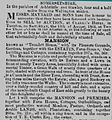 Sale notice for Tremlett 1864.jpg 800 × 856; 234 KB
-
 Saturated field, west of Kittisford - geograph.org.uk - 3819187.jpg 1,024 × 768; 190 KB
-
 Sign for Cothay Manor - geograph.org.uk - 4031594.jpg 640 × 480; 224 KB
-
 Signpost and field entrance, Cockland Hill - geograph.org.uk - 6704502.jpg 3,200 × 2,289; 2.94 MB
-
 Small barn on Bullock Field Hill, Kittisford Barton - geograph.org.uk - 6704519.jpg 3,200 × 2,127; 2.59 MB
-
 St Michael ^ All Angels church, Stawley - geograph.org.uk - 3237609.jpg 1,067 × 1,600; 378 KB
-
 St Michael's Church, Stawley - geograph.org.uk - 3819597.jpg 1,024 × 768; 144 KB
-
 St Peter's Church, Greenham - geograph.org.uk - 5103097.jpg 1,600 × 1,200; 784 KB
-
 St Peter's Church, Greenham - geograph.org.uk - 6668776.jpg 1,200 × 1,600; 1.01 MB
-
 Stawley , Country Lane - geograph.org.uk - 3921219.jpg 4,288 × 2,848; 5.9 MB
-
 Stawley , Country Lane - geograph.org.uk - 3921244.jpg 4,288 × 2,848; 6.43 MB
-
 Stawley , Country Lane - geograph.org.uk - 3921250.jpg 4,288 × 2,848; 6.27 MB
-
 Stawley , Country Lane - geograph.org.uk - 3921277.jpg 4,288 × 2,848; 6.12 MB
-
 Stawley , Country Lane - geograph.org.uk - 3921280.jpg 4,288 × 2,848; 6.24 MB
-
 Stawley , Grassy Field - geograph.org.uk - 3921247.jpg 4,288 × 2,848; 6.09 MB
-
 Stawley , Grassy Field ^ Houses - geograph.org.uk - 3921230.jpg 4,288 × 2,848; 5.14 MB
-
 Stawley , Ham Hill - geograph.org.uk - 3921240.jpg 4,288 × 2,848; 6.16 MB
-
 Stawley , St Michael's Church ^ House - geograph.org.uk - 3921235.jpg 4,288 × 2,848; 6.16 MB
-
 Stawley church and Church Cottage - geograph.org.uk - 3616334.jpg 3,888 × 2,592; 920 KB
-
 Stawley from Ham Hill.jpg 1,775 × 1,133; 291 KB
-
 Stawley from the north - geograph.org.uk - 3616337.jpg 3,888 × 2,592; 890 KB
-
 Stawley Mill - geograph.org.uk - 3819555.jpg 1,024 × 768; 240 KB
-
 Stawley Mill - geograph.org.uk - 6704536.jpg 3,200 × 2,400; 3.02 MB
-
 Stawley, by Lutley Bridge - geograph.org.uk - 145764.jpg 640 × 427; 238 KB
-
 Stawley, Gamlins Farm - geograph.org.uk - 148474.jpg 640 × 429; 146 KB
-
 Stawley, Tracebridge - geograph.org.uk - 167573.jpg 640 × 427; 202 KB
-
 Sunlight on bare trees east of Stawley - geograph.org.uk - 6704528.jpg 3,200 × 2,400; 2.53 MB
-
 Taunton Deane , Country Road - geograph.org.uk - 1332733.jpg 640 × 480; 73 KB
-

-

-

-

-

-

-

-

-
 Taunton Deane , Signpost and Road - geograph.org.uk - 1332698.jpg 640 × 480; 107 KB
-
 Taunton Deane District , Barn - geograph.org.uk - 4031461.jpg 4,288 × 2,848; 5.46 MB
-
 Taunton Deane District , Beardley Farm - geograph.org.uk - 4030444.jpg 4,288 × 2,848; 6.33 MB
-
 Taunton Deane District , Bullock Field Hill - geograph.org.uk - 4030447.jpg 4,288 × 2,848; 6.63 MB
-
 Taunton Deane District , Bullock Field Hill - geograph.org.uk - 4031379.jpg 4,288 × 2,848; 6.31 MB
-
 Taunton Deane District , Cattle Grazing - geograph.org.uk - 4031421.jpg 4,288 × 2,848; 6.15 MB
-
 Taunton Deane District , Cockland Hill - geograph.org.uk - 4022930.jpg 4,288 × 2,848; 6.31 MB
-
 Taunton Deane District , Cockland Hill - geograph.org.uk - 4023446.jpg 4,288 × 2,848; 6.3 MB
-
 Taunton Deane District , Cockland Hill - geograph.org.uk - 4023466.jpg 4,288 × 2,848; 6.3 MB
-
 Taunton Deane District , Cockland Hill - geograph.org.uk - 4023470.jpg 4,288 × 2,848; 6.45 MB
-
 Taunton Deane District , Construction Site - geograph.org.uk - 4022924.jpg 4,288 × 2,848; 6.09 MB
-
 Taunton Deane District , Country Lane - geograph.org.uk - 3921283.jpg 2,848 × 4,288; 6.3 MB
-
 Taunton Deane District , Country Lane - geograph.org.uk - 3921303.jpg 4,288 × 2,848; 6.45 MB
-
 Taunton Deane District , Country Lane - geograph.org.uk - 3921308.jpg 4,288 × 2,848; 6.34 MB
-
 Taunton Deane District , Country Lane - geograph.org.uk - 3921317.jpg 2,848 × 4,288; 6.19 MB
-
 Taunton Deane District , Country Lane - geograph.org.uk - 3921346.jpg 4,288 × 2,848; 6.77 MB
-
 Taunton Deane District , Country Lane - geograph.org.uk - 3921366.jpg 4,288 × 2,848; 5.34 MB
-
 Taunton Deane District , Country Lane - geograph.org.uk - 3921382.jpg 4,288 × 2,848; 6.64 MB
-
 Taunton Deane District , Country Lane - geograph.org.uk - 3921425.jpg 2,848 × 4,288; 6.44 MB
-
 Taunton Deane District , Country Lane - geograph.org.uk - 3921449.jpg 4,288 × 2,848; 6.79 MB
-
 Taunton Deane District , Country Lane - geograph.org.uk - 4022518.jpg 4,288 × 2,848; 6.13 MB
-
 Taunton Deane District , Country Lane - geograph.org.uk - 4022526.jpg 2,848 × 4,288; 6.24 MB
-
 Taunton Deane District , Country Lane - geograph.org.uk - 4030445.jpg 4,288 × 2,848; 6.16 MB
-
 Taunton Deane District , Country Lane - geograph.org.uk - 4030452.jpg 4,288 × 2,848; 6.81 MB
-
 Taunton Deane District , Country Lane - geograph.org.uk - 4030455.jpg 4,288 × 2,848; 6.91 MB
-
 Taunton Deane District , Country Lane - geograph.org.uk - 4030458.jpg 4,288 × 2,848; 6.19 MB
-
 Taunton Deane District , Country Lane - geograph.org.uk - 4031383.jpg 4,288 × 2,848; 6.79 MB
-
 Taunton Deane District , Country Lane - geograph.org.uk - 4031386.jpg 2,848 × 4,288; 6.56 MB
-
 Taunton Deane District , Country Lane - geograph.org.uk - 4031388.jpg 4,288 × 2,848; 6.59 MB
-
 Taunton Deane District , Country Lane - geograph.org.uk - 4031410.jpg 4,288 × 2,848; 6.13 MB
-
 Taunton Deane District , Country Lane - geograph.org.uk - 4031426.jpg 4,288 × 2,848; 5.75 MB


_-_geograph.org.uk_-_3155693.jpg)


