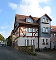
Category:Steinstraße 21 (Kronberg)
This is the category of the Hessian Kulturdenkmal (cultural monument) with the ID 99978 (Wikidata)
|
| Object location | | View all coordinates using: OpenStreetMap |
|---|
 | |||||
| Upload media | |||||
| Instance of | |||||
|---|---|---|---|---|---|
| Location | Kronberg im Taunus, Hochtaunuskreis, Darmstadt Government Region, Hesse, Germany | ||||
| Heritage designation | |||||
| Different from | |||||
 | |||||
Media in category "Steinstraße 21 (Kronberg)"
The following 3 files are in this category, out of 3 total.
-
 Kronberg, Steinstraße 21 (1).jpg 5,464 × 5,608; 16.67 MB
-
 Kronberg, Steinstraße 21.jpg 4,384 × 4,752; 12.03 MB
-
 Steinstrasse-21-Kronberg-JR-E-5229-2021-05-13.jpg 2,879 × 4,218; 5.2 MB
.jpg)
