Category:Stonington Harbor Light
| Object location | | View all coordinates using: OpenStreetMap |
|---|
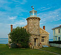
English: Stonington Harbor Light
lighthouse in Stonington, Connecticut, United States  | |||||
| Upload media | |||||
| Instance of | |||||
|---|---|---|---|---|---|
| Made from material |
| ||||
| Location |
| ||||
| Operator |
| ||||
| Heritage designation | |||||
| Service entry |
| ||||
| Service retirement |
| ||||
| Inception |
| ||||
| Height |
| ||||
 | |||||
Media in category "Stonington Harbor Light"
The following 8 files are in this category, out of 8 total.
-
 INTERIOR OF STONINGTON HARBOR LIGHTHOUSE, STONINGTON, CT.jpg 5,262 × 3,474; 1.67 MB
-
 Stonington Harbor Light.jpg 4,896 × 3,672; 13.3 MB
-
 Stonington Harbor Lighthouse 2007 side view.jpg 2,000 × 1,663; 1.56 MB
-
 Stonington Harbor Lighthouse 2007.jpg 2,000 × 1,797; 1.08 MB
-
 Stonington light.png 1,000 × 911; 741 KB
-
 StoningtonHarborLight1.JPG 4,288 × 2,848; 5.01 MB
-
 StoningtonHarborLight2.JPG 4,288 × 2,848; 4.7 MB
-
 The Old Lighthouse, Stonington, Conn (78849).jpg 3,305 × 2,133; 2.75 MB


.jpg)