Category:Streets in Rye
Subcategories
This category has the following 9 subcategories, out of 9 total.
C
E
- East Street, Rye (14 F)
H
L
- Lion Street, Rye (19 F)
M
- The Mint, Rye (29 F)
T
- Turkey Cock Lane, Rye (1 F)
W
- Watchbell Street, Rye (11 F)
Media in category "Streets in Rye"
The following 21 files are in this category, out of 21 total.
-
 Alma Place, Rye - geograph.org.uk - 1423382.jpg 640 × 480; 78 KB
-
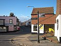
 Cinque Ports Street - geograph.org.uk - 1740391.jpg 640 × 430; 128 KB
-
 Cinque Ports Street - geograph.org.uk - 3668148.jpg 640 × 424; 269 KB
-
 Cinque Ports Street - geograph.org.uk - 3668156.jpg 424 × 640; 280 KB
-
 Cinque Ports Street, Rye - geograph.org.uk - 1423353.jpg 640 × 480; 89 KB
-
 Cobbled Road - panoramio.jpg 4,167 × 2,768; 11.43 MB
-
 Conduit Hill - geograph.org.uk - 300190.jpg 479 × 640; 139 KB
-
 Conduit Hill, Rye - geograph.org.uk - 1423244.jpg 640 × 480; 130 KB
-
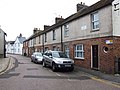
 East Cliff, Rye - geograph.org.uk - 1423305.jpg 640 × 480; 95 KB
-
 Ferry Rd, Rye - geograph.org.uk - 2208099.jpg 640 × 430; 129 KB
-
 Ferry Road - geograph.org.uk - 2234061.jpg 640 × 480; 75 KB
-
 Ferry Road, Rye - geograph.org.uk - 1423362.jpg 640 × 480; 86 KB
-
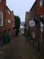
 Ockmans Lane - geograph.org.uk - 401714.jpg 479 × 640; 129 KB
-
 Rope Walk - geograph.org.uk - 446225.jpg 479 × 640; 112 KB
-
 Rope Walk, Rye - geograph.org.uk - 1423338.jpg 640 × 480; 69 KB
-
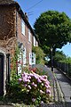 Roses-in-Rye.jpg 3,072 × 4,608; 3.06 MB
-
 Rye, Martello Close - geograph.org.uk - 3170543.jpg 3,648 × 2,736; 4.3 MB
-
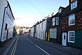
 Tower Street, Rye - geograph.org.uk - 1423325.jpg 640 × 480; 84 KB
-
 Traders Passage, Rye - geograph.org.uk - 1423155.jpg 640 × 480; 94 KB
-
 Traders Passage, Rye - geograph.org.uk - 2611256.jpg 640 × 430; 74 KB
-
 Udimore Road (B2089), Rye in 1972 - geograph.org.uk - 1746618.jpg 788 × 536; 107 KB


,_Rye_in_1972_-_geograph.org.uk_-_1746618.jpg)