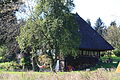
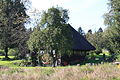
Category:Strohdachhaus Hendschiken
| Object location | | View all coordinates using: OpenStreetMap |
|---|
building in Hendschiken in the canton of Aargau, Switzerland  | |||||
| Upload media | |||||
| Instance of |
| ||||
|---|---|---|---|---|---|
| Part of | |||||
| Location | Hendschiken, Lenzburg District, Aargau, Switzerland | ||||
| Street address |
| ||||
| Heritage designation | |||||
| Inception |
| ||||
 | |||||
Media in category "Strohdachhaus Hendschiken"
The following 3 files are in this category, out of 3 total.
-
 Hendschiken Strohdachhaus KSG 9857 2012-09-28 01.jpg 3,888 × 2,592; 6.08 MB
-
 Hendschiken Strohdachhaus KSG 9857 2012-09-28 02.jpg 3,888 × 2,592; 5.88 MB
-
 Hendschiken Strohdachhaus KSG 9857 2012-09-28 03.jpg 3,888 × 2,592; 6.37 MB

