Category:Strubby with Woodthorpe
English: Strubby with Woodthorpe is a civil parish in the East Lindsey district, in the county of Lincolnshire, England.
civil parish in East Lindsey, Lincolnshire, England | |||||
| Upload media | |||||
| Instance of | |||||
|---|---|---|---|---|---|
| Location | East Lindsey, Lincolnshire, East Midlands, England | ||||
 | |||||
Subcategories
This category has the following 3 subcategories, out of 3 total.
S
- St Oswald's church, Strubby (empty)
W
- Woodthorpe, Lincolnshire (1 F)
Media in category "Strubby with Woodthorpe"
The following 105 files are in this category, out of 105 total.
-
 14th century effigy - geograph.org.uk - 6264585.jpg 1,024 × 683; 166 KB
-
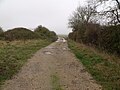
 A bridleway leading to Strubby - geograph.org.uk - 2899438.jpg 800 × 600; 134 KB
-
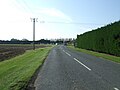
 A157 heading east - geograph.org.uk - 3524236.jpg 640 × 480; 73 KB
-
 A157 near Strubby - geograph.org.uk - 3223839.jpg 3,088 × 2,056; 1.55 MB
-

-

-
 B1373 near Woodthorpe House Farm - geograph.org.uk - 4682869.jpg 640 × 480; 62 KB
-
 B1373 towards Withern - geograph.org.uk - 4682866.jpg 640 × 480; 88 KB
-

-
 Deserted village of Stain, aerial 2015 - geograph.org.uk - 4304710.jpg 1,024 × 570; 81 KB
-
 Details about 404 Squadron, RAF Strubby - geograph.org.uk - 6252390.jpg 3,036 × 2,168; 749 KB
-
 Details about 619 Squadron, RAF Strubby - geograph.org.uk - 6252392.jpg 4,608 × 3,072; 4.87 MB
-

-

-
 Electricity pole by the B1373 - geograph.org.uk - 3282877.jpg 768 × 1,024; 102 KB
-
 Farm buildings at Woodthorpe Hall - geograph.org.uk - 2899406.jpg 800 × 544; 100 KB
-
 Farm buildings, Woodthorpe Hall - geograph.org.uk - 4657882.jpg 640 × 480; 83 KB
-
 Field near Woodthorpe House Farm - geograph.org.uk - 4657876.jpg 640 × 480; 75 KB
-

-
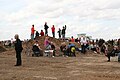
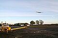
 Fly-in at Strubby, July 2013 - geograph.org.uk - 3574235.jpg 640 × 427; 49 KB
-
 Fly-in at Strubby, July 2013 - geograph.org.uk - 3574236.jpg 640 × 427; 41 KB
-
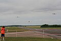 Fly-past at Strubby - geograph.org.uk - 3574267.jpg 640 × 427; 34 KB
-
 Flying display, Strubby - geograph.org.uk - 4614975.jpg 640 × 427; 12 KB
-
 Flying display, Strubby - geograph.org.uk - 4614980.jpg 640 × 427; 12 KB
-

-
 Former R.A.F. Strubby - geograph.org.uk - 3188974.jpg 640 × 430; 53 KB
-
 Former R.A.F. Strubby, aerial 2010 - geograph.org.uk - 4314247.jpg 640 × 427; 52 KB
-
 Former R.A.F. Strubby, new uses - geograph.org.uk - 3574262.jpg 640 × 427; 46 KB
-

-

-
-

-

-
 Gap in the trees - geograph.org.uk - 1219648.jpg 640 × 480; 81 KB
-
 Garden Centre on a bend in the B1373 - geograph.org.uk - 3954286.jpg 640 × 427; 48 KB
-

-

-
 Golf course at Woodthorpe Hall, aerial 2014 - geograph.org.uk - 3870928.jpg 1,024 × 683; 140 KB
-

-
 Grazing near Woodthorpe Hall - geograph.org.uk - 4682871.jpg 640 × 480; 84 KB
-
 Grazing, Manor Farm - geograph.org.uk - 3524230.jpg 640 × 480; 86 KB
-
 Grazing, Strubby - geograph.org.uk - 3524223.jpg 640 × 480; 52 KB
-
 Green Lane - geograph.org.uk - 3873239.jpg 683 × 1,024; 135 KB
-
 Hay Bales near Green Lane - geograph.org.uk - 2516569.jpg 640 × 480; 61 KB
-
 House off Field Lane - geograph.org.uk - 2517178.jpg 1,280 × 960; 818 KB
-
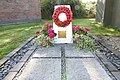 In memory of Flt-Lt Peter Le Brocq, 21-07-1944, age 19 - geograph.org.uk - 6252405.jpg 4,608 × 3,072; 5.4 MB
-
 Information board at Strubby airfield - geograph.org.uk - 6252389.jpg 3,257 × 1,900; 752 KB
-

-
 Little brick shed with a chimney - geograph.org.uk - 3873244.jpg 640 × 427; 60 KB
-
 Maltby le Marsh, aerial 2017 - geograph.org.uk - 5324051.jpg 640 × 427; 56 KB
-

-
 Memorial to William Bailett ^ family, Strubby church - geograph.org.uk - 4136639.jpg 2,147 × 3,845; 4.76 MB
-

-

-

-
 Old Ruston engine - geograph.org.uk - 3166578.jpg 640 × 423; 104 KB
-
 Old Ruston engine - geograph.org.uk - 3166580.jpg 640 × 423; 97 KB
-
 Old Ruston engine - geograph.org.uk - 3166583.jpg 640 × 423; 106 KB
-

-

-

-
 Original building on RAF Strubby airfield - geograph.org.uk - 6252388.jpg 4,608 × 3,072; 5.6 MB
-

-
 Path to Strubby Airfield - geograph.org.uk - 2693301.jpg 1,280 × 960; 367 KB
-
-

-

-
 Poppy head, St Oswald's Church, Strubby - geograph.org.uk - 4136534.jpg 1,067 × 1,600; 256 KB
-

-
 RAF Strubby memorial - geograph.org.uk - 6252382.jpg 4,608 × 3,072; 2.98 MB
-
 RAF Strubby memorial - geograph.org.uk - 6252384.jpg 2,196 × 2,676; 1.15 MB
-
 Red Arrows fly-past at Strubby - geograph.org.uk - 4137475.jpg 640 × 427; 49 KB
-
 Remarkable oak, Woodthorpe - geograph.org.uk - 3278420.jpg 1,024 × 768; 225 KB
-

-
 Road into Strubby - geograph.org.uk - 3524227.jpg 640 × 480; 59 KB
-

-

-

-

-

-

-
 Split level road - geograph.org.uk - 3279647.jpg 640 × 427; 96 KB
-

-

-
 Straw stack on Strubby airfield - geograph.org.uk - 3282847.jpg 1,024 × 768; 154 KB
-

-
 Strubby airfield, formerly RAF Strubby, aerial - geograph.org.uk - 3087629.jpg 1,024 × 683; 139 KB
-

-

-

-
 The churchyard and Old Rectory, Strubby - geograph.org.uk - 3898970.jpg 1,024 × 768; 246 KB
-
 The left face of RAF Strubby memorial - geograph.org.uk - 6252385.jpg 1,460 × 1,568; 515 KB
-
 The rear face of RAF Strubby memorial - geograph.org.uk - 6252387.jpg 2,868 × 2,284; 1.36 MB
-
 The right face of RAF Strubby memorial - geograph.org.uk - 6252386.jpg 1,672 × 1,564; 437 KB
-
 Track near Field Lane - geograph.org.uk - 2517196.jpg 640 × 480; 94 KB
-
 Trees and field near Strubby Grange - geograph.org.uk - 1219697.jpg 640 × 480; 87 KB
-
 Two Avro Lancasters at Strubby Airfield - geograph.org.uk - 4139181.jpg 1,940 × 2,498; 1.98 MB
-
 Two Avro Lancasters fly over Strubby Airfield - geograph.org.uk - 4139190.jpg 1,760 × 2,408; 1.54 MB
-

-
 Warehouse, Strubby Airfield - geograph.org.uk - 3278426.jpg 1,024 × 768; 84 KB
-
 William Ballett memorial - geograph.org.uk - 6264597.jpg 1,024 × 875; 222 KB
-
 Woodthorpe from Toot Hill - geograph.org.uk - 3854314.jpg 640 × 427; 44 KB
-
 Woodthorpe Hall - geograph.org.uk - 3954292.jpg 640 × 427; 79 KB
-

-
 WW2 Control Tower EX RAF Strubby - geograph.org.uk - 4806867.jpg 4,608 × 3,456; 3.47 MB


