Category:Survey monument JF00-072 (Kansas-Nebraska)
| Object location | | View all coordinates using: OpenStreetMap |
|---|
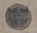
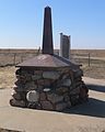
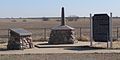
survey monument marking the boundary of Kansas and Nebraska, USA  | |||||
| Upload media | |||||
| Instance of | |||||
|---|---|---|---|---|---|
| Location |
| ||||
| Heritage designation |
| ||||
 | |||||
Coordinates were taken from Google Maps, based on aerial photo; according to that, the intersection is north of the 40th parallel.
Media in category "Survey monument JF00-072 (Kansas-Nebraska)"
The following 14 files are in this category, out of 14 total.
-
 Survey monument JF00-072 disc marker 1.JPG 1,852 × 1,657; 1.29 MB
-
 Survey monument JF00-072 disc marker 2.JPG 1,700 × 1,621; 1.14 MB
-
 Survey monument JF00-072 from NE 1.JPG 1,728 × 2,160; 1.31 MB
-
 Survey monument JF00-072 from S 1.JPG 2,560 × 1,737; 1.68 MB
-
 Survey monument JF00-072 from SW 1.JPG 2,560 × 1,224; 1.36 MB
-
 Survey monument JF00-072 from W 1.JPG 1,469 × 1,809; 929 KB
-
 Survey monument JF00-072 from W 2.JPG 2,336 × 1,163; 1.09 MB
-
 Survey monument JF00-072 from W 3.JPG 2,452 × 1,317; 1.41 MB
-
 Survey monument JF00-072 historical marker.JPG 1,469 × 1,809; 1.19 MB
-
 Survey monument JF00-072 setting from S 1.JPG 2,412 × 1,116; 1.04 MB
-
 Survey monument JF00-072 setting from W 1.JPG 2,424 × 1,613; 1.62 MB
-
 Survey monument JF00-072 surveyor plaque.JPG 1,736 × 1,420; 1.09 MB
-
 Survey monument JF00-072 W witness post 1.JPG 1,363 × 2,018; 1.22 MB
-
 Survey monument JF00-072 W witness post 2.JPG 1,493 × 1,642; 1.07 MB


